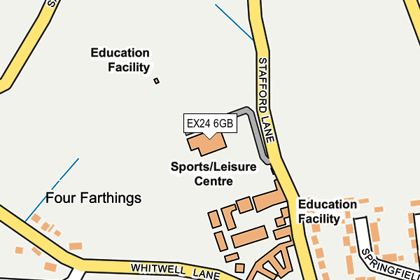
EX24 6GB is located in the Coly Valley electoral ward, within the local authority district of East Devon and the English Parliamentary constituency of Tiverton and Honiton. The Sub Integrated Care Board (ICB) Location is NHS Devon ICB - 15N and the police force is Devon & Cornwall. This postcode has been in use since January 2004.


GetTheData
Source: OS OpenMap – Local (Ordnance Survey)
Source: OS VectorMap District (Ordnance Survey)
Licence: Open Government Licence (requires attribution)
| Easting | 324335 |
| Northing | 92732 |
| Latitude | 50.729259 |
| Longitude | -3.073435 |
GetTheData
Source: Open Postcode Geo
Licence: Open Government Licence
| Country | England |
| Postcode District | EX24 |
| ➜ EX24 open data dashboard ➜ See where EX24 is on a map ➜ Where is Colyford? | |
GetTheData
Source: Land Registry Price Paid Data
Licence: Open Government Licence
Elevation or altitude of EX24 6GB as distance above sea level:
| Metres | Feet | |
|---|---|---|
| Elevation | 50m | 164ft |
Elevation is measured from the approximate centre of the postcode, to the nearest point on an OS contour line from OS Terrain 50, which has contour spacing of ten vertical metres.
➜ How high above sea level am I? Find the elevation of your current position using your device's GPS.
GetTheData
Source: Open Postcode Elevation
Licence: Open Government Licence
| Ward | Coly Valley |
| Constituency | Tiverton And Honiton |
GetTheData
Source: ONS Postcode Database
Licence: Open Government Licence
| June 2022 | Criminal damage and arson | On or near Fair View Lane | 356m |
| June 2022 | Criminal damage and arson | On or near Springfields | 359m |
| November 2021 | Anti-social behaviour | On or near Fair View Lane | 356m |
| ➜ Get more crime data in our Crime section | |||
GetTheData
Source: data.police.uk
Licence: Open Government Licence
| The Elms (Swan Hill Road) | Colyford | 569m |
| The Elms (Swan Hill Road) | Colyford | 587m |
| Harepath Hill (Harepath Road) | Colyford | 790m |
| Harepath Hill (Harepath Road) | Colyford | 791m |
| Coly Vale (Coly Road) | Colyton | 811m |
| Colyford Station (Seaton Tramway) (Swan Hill Road) | Colyford | 1,097m |
| Colyton Station (Seaton Tramway) (Station Road) | Colyton | 1,581m |
GetTheData
Source: NaPTAN
Licence: Open Government Licence
GetTheData
Source: ONS Postcode Database
Licence: Open Government Licence


➜ Get more ratings from the Food Standards Agency
GetTheData
Source: Food Standards Agency
Licence: FSA terms & conditions
| Last Collection | |||
|---|---|---|---|
| Location | Mon-Fri | Sat | Distance |
| Shells Lane | 16:45 | 07:30 | 816m |
| Sidmouth Road | 16:45 | 10:30 | 1,162m |
| Station Road | 16:45 | 11:00 | 1,598m |
GetTheData
Source: Dracos
Licence: Creative Commons Attribution-ShareAlike
| Facility | Distance |
|---|---|
| Colyton Leisure Centre Stafford Lane, Colyford, Colyton Sports Hall, Artificial Grass Pitch, Grass Pitches, Studio | 0m |
| Peace Memorial Playing Fields Coly Road, Colyton Grass Pitches, Outdoor Tennis Courts | 976m |
| Seaton Heights Hotel Leisure Centre (Closed) Harepath Hill, Seaton Health and Fitness Gym, Swimming Pool, Sports Hall, Squash Courts | 1.4km |
GetTheData
Source: Active Places
Licence: Open Government Licence
| School | Phase of Education | Distance |
|---|---|---|
| Colyton Grammar School Whitwell Lane, Colyford, Colyton, EX24 6HN | Secondary | 198m |
| Colyton Primary Academy The Butts, West Street, Colyton, EX24 6NU | Primary | 1.2km |
| Seaton Primary School Valley View, Seaton, EX12 2HF | Primary | 1.9km |
GetTheData
Source: Edubase
Licence: Open Government Licence
The below table lists the International Territorial Level (ITL) codes (formerly Nomenclature of Territorial Units for Statistics (NUTS) codes) and Local Administrative Units (LAU) codes for EX24 6GB:
| ITL 1 Code | Name |
|---|---|
| TLK | South West (England) |
| ITL 2 Code | Name |
| TLK4 | Devon |
| ITL 3 Code | Name |
| TLK43 | Devon CC |
| LAU 1 Code | Name |
| E07000040 | East Devon |
GetTheData
Source: ONS Postcode Directory
Licence: Open Government Licence
The below table lists the Census Output Area (OA), Lower Layer Super Output Area (LSOA), and Middle Layer Super Output Area (MSOA) for EX24 6GB:
| Code | Name | |
|---|---|---|
| OA | E00100714 | |
| LSOA | E01019900 | East Devon 007B |
| MSOA | E02004135 | East Devon 007 |
GetTheData
Source: ONS Postcode Directory
Licence: Open Government Licence
| EX24 6HQ | Stafford Lane | 163m |
| EX24 6HP | Whitwell Lane | 256m |
| EX24 6HN | Whitwell Lane | 270m |
| EX24 6RE | Springfields | 304m |
| EX24 6RF | Branscombe Close | 345m |
| EX24 6QY | Elm Villas | 374m |
| EX24 6RB | Fairview Lane | 381m |
| EX24 6RA | Fairview Lane | 389m |
| EX24 6QS | Elm Farm Lane | 402m |
| EX24 6RD | Springfields | 416m |
GetTheData
Source: Open Postcode Geo; Land Registry Price Paid Data
Licence: Open Government Licence