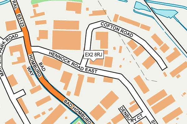
EX2 8RJ is located in the Alphington electoral ward, within the local authority district of Exeter and the English Parliamentary constituency of Exeter. The Sub Integrated Care Board (ICB) Location is NHS Devon ICB - 15N and the police force is Devon & Cornwall. This postcode has been in use since October 2002.


GetTheData
Source: OS OpenMap – Local (Ordnance Survey)
Source: OS VectorMap District (Ordnance Survey)
Licence: Open Government Licence (requires attribution)
| Easting | 292674 |
| Northing | 90057 |
| Latitude | 50.700208 |
| Longitude | -3.521119 |
GetTheData
Source: Open Postcode Geo
Licence: Open Government Licence
| Country | England |
| Postcode District | EX2 |
➜ See where EX2 is on a map ➜ Where is Exeter? | |
GetTheData
Source: Land Registry Price Paid Data
Licence: Open Government Licence
Elevation or altitude of EX2 8RJ as distance above sea level:
| Metres | Feet | |
|---|---|---|
| Elevation | 10m | 33ft |
Elevation is measured from the approximate centre of the postcode, to the nearest point on an OS contour line from OS Terrain 50, which has contour spacing of ten vertical metres.
➜ How high above sea level am I? Find the elevation of your current position using your device's GPS.
GetTheData
Source: Open Postcode Elevation
Licence: Open Government Licence
| Ward | Alphington |
| Constituency | Exeter |
GetTheData
Source: ONS Postcode Database
Licence: Open Government Licence
| Cofton Road (Hennock Road East) | Marsh Barton | 69m |
| Cofton Road (Hennock Road East) | Marsh Barton | 72m |
| Denbury Court (Silverton Road) | Marsh Barton | 238m |
| Bentley West Country (Matford Park Road) | Marsh Barton | 265m |
| Bentley West Country (Matford Park Road) | Marsh Barton | 268m |
| Exeter St Thomas Station | 2.3km |
| Exeter Central Station | 3km |
| St James Park (Devon) Station | 3.4km |
GetTheData
Source: NaPTAN
Licence: Open Government Licence
GetTheData
Source: ONS Postcode Database
Licence: Open Government Licence


➜ Get more ratings from the Food Standards Agency
GetTheData
Source: Food Standards Agency
Licence: FSA terms & conditions
| Last Collection | |||
|---|---|---|---|
| Location | Mon-Fri | Sat | Distance |
| Matford Park Road | 19:15 | 335m | |
| Matford Park Road | 19:15 | 12:45 | 335m |
| Grace Road | 19:15 | 12:45 | 736m |
GetTheData
Source: Dracos
Licence: Creative Commons Attribution-ShareAlike
| Risk of EX2 8RJ flooding from rivers and sea | Low |
| ➜ EX2 8RJ flood map | |
GetTheData
Source: Open Flood Risk by Postcode
Licence: Open Government Licence
The below table lists the International Territorial Level (ITL) codes (formerly Nomenclature of Territorial Units for Statistics (NUTS) codes) and Local Administrative Units (LAU) codes for EX2 8RJ:
| ITL 1 Code | Name |
|---|---|
| TLK | South West (England) |
| ITL 2 Code | Name |
| TLK4 | Devon |
| ITL 3 Code | Name |
| TLK43 | Devon CC |
| LAU 1 Code | Name |
| E07000041 | Exeter |
GetTheData
Source: ONS Postcode Directory
Licence: Open Government Licence
The below table lists the Census Output Area (OA), Lower Layer Super Output Area (LSOA), and Middle Layer Super Output Area (MSOA) for EX2 8RJ:
| Code | Name | |
|---|---|---|
| OA | E00101076 | |
| LSOA | E01019970 | Exeter 014C |
| MSOA | E02004162 | Exeter 014 |
GetTheData
Source: ONS Postcode Directory
Licence: Open Government Licence
| EX2 8ND | Silverton Road | 131m |
| EX2 8QW | Cofton Road | 138m |
| EX2 8HY | Silverton Road | 220m |
| EX2 8PW | Lustleigh Close | 222m |
| EX2 8FD | Matford Park Road | 331m |
| EX2 8WA | Oaktree Place | 391m |
| EX2 8PF | Manaton Close | 392m |
| EX2 8GN | Newton Centre | 418m |
| EX2 8QF | Alphinbrook Road | 429m |
| EX2 8NL | Sigford Road | 458m |
GetTheData
Source: Open Postcode Geo; Land Registry Price Paid Data
Licence: Open Government Licence