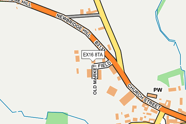
EX16 8TA is located in the Witheridge electoral ward, within the local authority district of North Devon and the English Parliamentary constituency of North Devon. The Sub Integrated Care Board (ICB) Location is NHS Devon ICB - 15N and the police force is Devon & Cornwall. This postcode has been in use since December 1996.


GetTheData
Source: OS OpenMap – Local (Ordnance Survey)
Source: OS VectorMap District (Ordnance Survey)
Licence: Open Government Licence (requires attribution)
| Easting | 280138 |
| Northing | 114690 |
| Latitude | 50.919177 |
| Longitude | -3.706606 |
GetTheData
Source: Open Postcode Geo
Licence: Open Government Licence
| Country | England |
| Postcode District | EX16 |
| ➜ EX16 open data dashboard ➜ See where EX16 is on a map ➜ Where is Witheridge? | |
GetTheData
Source: Land Registry Price Paid Data
Licence: Open Government Licence
Elevation or altitude of EX16 8TA as distance above sea level:
| Metres | Feet | |
|---|---|---|
| Elevation | 180m | 591ft |
Elevation is measured from the approximate centre of the postcode, to the nearest point on an OS contour line from OS Terrain 50, which has contour spacing of ten vertical metres.
➜ How high above sea level am I? Find the elevation of your current position using your device's GPS.
GetTheData
Source: Open Postcode Elevation
Licence: Open Government Licence
| Ward | Witheridge |
| Constituency | North Devon |
GetTheData
Source: ONS Postcode Database
Licence: Open Government Licence
| August 2022 | Anti-social behaviour | On or near Broomhouse Park | 380m |
| June 2022 | Other theft | On or near Broomhouse Park | 380m |
| June 2022 | Anti-social behaviour | On or near Cannington Road | 428m |
| ➜ Get more crime data in our Crime section | |||
GetTheData
Source: data.police.uk
Licence: Open Government Licence
| The Mitre Inn (Church Street) | Witheridge | 302m |
| The Mitre Inn (Church Street) | Witheridge | 304m |
| School (B3137) | Witheridge | 687m |
| School (B3137) | Witheridge | 708m |
| Lakelands Close (B3137) | Witheridge | 792m |
GetTheData
Source: NaPTAN
Licence: Open Government Licence
GetTheData
Source: ONS Postcode Database
Licence: Open Government Licence


➜ Get more ratings from the Food Standards Agency
GetTheData
Source: Food Standards Agency
Licence: FSA terms & conditions
| Last Collection | |||
|---|---|---|---|
| Location | Mon-Fri | Sat | Distance |
| Thelbridge Cross | 15:30 | 08:00 | 2,898m |
GetTheData
Source: Dracos
Licence: Creative Commons Attribution-ShareAlike
| Facility | Distance |
|---|---|
| Witheridge Sports Field Fore Street, Witheridge Grass Pitches | 762m |
| Witheridge Incorrigibles Cricket Club (Closed) Nomansland, Tiverton Grass Pitches | 3.4km |
GetTheData
Source: Active Places
Licence: Open Government Licence
| School | Phase of Education | Distance |
|---|---|---|
| Witheridge Church of England Primary Academy Fore Street, Witheridge, Tiverton, EX16 8AH | Primary | 716m |
| East Worlington Primary School East Worlington, Crediton, EX17 4TS | Primary | 2.8km |
| Rackenford Church of England Primary School Rackenford, Tiverton, EX16 8DU | Primary | 6km |
GetTheData
Source: Edubase
Licence: Open Government Licence
The below table lists the International Territorial Level (ITL) codes (formerly Nomenclature of Territorial Units for Statistics (NUTS) codes) and Local Administrative Units (LAU) codes for EX16 8TA:
| ITL 1 Code | Name |
|---|---|
| TLK | South West (England) |
| ITL 2 Code | Name |
| TLK4 | Devon |
| ITL 3 Code | Name |
| TLK43 | Devon CC |
| LAU 1 Code | Name |
| E07000043 | North Devon |
GetTheData
Source: ONS Postcode Directory
Licence: Open Government Licence
The below table lists the Census Output Area (OA), Lower Layer Super Output Area (LSOA), and Middle Layer Super Output Area (MSOA) for EX16 8TA:
| Code | Name | |
|---|---|---|
| OA | E00101977 | |
| LSOA | E01020138 | North Devon 014C |
| MSOA | E02004188 | North Devon 014 |
GetTheData
Source: ONS Postcode Directory
Licence: Open Government Licence
| EX16 8PU | 151m | |
| EX16 8AE | The Square | 283m |
| EX16 8AA | West Street | 309m |
| EX16 8AD | Tracey Green | 320m |
| EX16 8DG | The Square | 332m |
| EX16 8HB | Broomhouse Park | 371m |
| EX16 8AB | Pullens Row | 381m |
| EX16 8PR | Drayford Lane | 388m |
| EX16 8EB | Benson Close | 431m |
| EX16 8DF | Harvey Close | 431m |
GetTheData
Source: Open Postcode Geo; Land Registry Price Paid Data
Licence: Open Government Licence