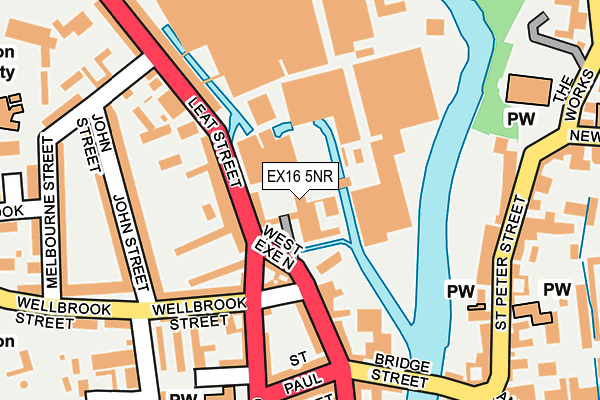
EX16 5NR is located in the Tiverton Westexe electoral ward, within the local authority district of Mid Devon and the English Parliamentary constituency of Tiverton and Honiton. The Sub Integrated Care Board (ICB) Location is NHS Devon ICB - 15N and the police force is Devon & Cornwall. This postcode has been in use since July 2013.


GetTheData
Source: OS OpenMap – Local (Ordnance Survey)
Source: OS VectorMap District (Ordnance Survey)
Licence: Open Government Licence (requires attribution)
| Easting | 295189 |
| Northing | 112730 |
| Latitude | 50.904498 |
| Longitude | -3.491985 |
GetTheData
Source: Open Postcode Geo
Licence: Open Government Licence
| Country | England |
| Postcode District | EX16 |
➜ See where EX16 is on a map ➜ Where is Tiverton? | |
GetTheData
Source: Land Registry Price Paid Data
Licence: Open Government Licence
Elevation or altitude of EX16 5NR as distance above sea level:
| Metres | Feet | |
|---|---|---|
| Elevation | 60m | 197ft |
Elevation is measured from the approximate centre of the postcode, to the nearest point on an OS contour line from OS Terrain 50, which has contour spacing of ten vertical metres.
➜ How high above sea level am I? Find the elevation of your current position using your device's GPS.
GetTheData
Source: Open Postcode Elevation
Licence: Open Government Licence
| Ward | Tiverton Westexe |
| Constituency | Tiverton And Honiton |
GetTheData
Source: ONS Postcode Database
Licence: Open Government Licence
| St Paul Street | Tiverton | 188m |
| West Exe South | Tiverton | 227m |
| Old School Close (King Street) | Cotteylands | 233m |
| West Exe South | Tiverton | 250m |
| Castle Street (Newport Street) | Tiverton | 298m |
GetTheData
Source: NaPTAN
Licence: Open Government Licence
GetTheData
Source: ONS Postcode Database
Licence: Open Government Licence


➜ Get more ratings from the Food Standards Agency
GetTheData
Source: Food Standards Agency
Licence: FSA terms & conditions
| Last Collection | |||
|---|---|---|---|
| Location | Mon-Fri | Sat | Distance |
| Wilcombe Post Office | 17:00 | 12:00 | 149m |
| St Peter Street | 17:30 | 12:00 | 220m |
| Town Hall | 17:30 | 12:00 | 329m |
GetTheData
Source: Dracos
Licence: Creative Commons Attribution-ShareAlike
| Risk of EX16 5NR flooding from rivers and sea | Medium |
| ➜ EX16 5NR flood map | |
GetTheData
Source: Open Flood Risk by Postcode
Licence: Open Government Licence
The below table lists the International Territorial Level (ITL) codes (formerly Nomenclature of Territorial Units for Statistics (NUTS) codes) and Local Administrative Units (LAU) codes for EX16 5NR:
| ITL 1 Code | Name |
|---|---|
| TLK | South West (England) |
| ITL 2 Code | Name |
| TLK4 | Devon |
| ITL 3 Code | Name |
| TLK43 | Devon CC |
| LAU 1 Code | Name |
| E07000042 | Mid Devon |
GetTheData
Source: ONS Postcode Directory
Licence: Open Government Licence
The below table lists the Census Output Area (OA), Lower Layer Super Output Area (LSOA), and Middle Layer Super Output Area (MSOA) for EX16 5NR:
| Code | Name | |
|---|---|---|
| OA | E00101670 | |
| LSOA | E01020078 | Mid Devon 005B |
| MSOA | E02004168 | Mid Devon 005 |
GetTheData
Source: ONS Postcode Directory
Licence: Open Government Licence
| EX16 5LZ | Bridge Buildings | 72m |
| EX16 5LJ | Leat Street | 74m |
| EX16 5JN | Wellbrook Street | 92m |
| EX16 5LQ | Harmony Place | 94m |
| EX16 5HY | Church Street | 94m |
| EX16 5LX | West Exe North | 121m |
| EX16 5JW | Wellbrook Street | 136m |
| EX16 5HX | Church Street | 149m |
| EX16 5LG | Leat Street | 155m |
| EX16 5JP | John Street | 165m |
GetTheData
Source: Open Postcode Geo; Land Registry Price Paid Data
Licence: Open Government Licence