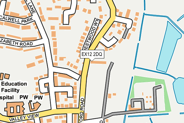
EX12 2DQ is located in the Seaton electoral ward, within the local authority district of East Devon and the English Parliamentary constituency of Tiverton and Honiton. The Sub Integrated Care Board (ICB) Location is NHS Devon ICB - 15N and the police force is Devon & Cornwall. This postcode has been in use since January 1980.


GetTheData
Source: OS OpenMap – Local (Ordnance Survey)
Source: OS VectorMap District (Ordnance Survey)
Licence: Open Government Licence (requires attribution)
| Easting | 324697 |
| Northing | 90955 |
| Latitude | 50.713329 |
| Longitude | -3.067943 |
GetTheData
Source: Open Postcode Geo
Licence: Open Government Licence
| Country | England |
| Postcode District | EX12 |
| ➜ EX12 open data dashboard ➜ See where EX12 is on a map ➜ Where is Seaton? | |
GetTheData
Source: Land Registry Price Paid Data
Licence: Open Government Licence
Elevation or altitude of EX12 2DQ as distance above sea level:
| Metres | Feet | |
|---|---|---|
| Elevation | 10m | 33ft |
Elevation is measured from the approximate centre of the postcode, to the nearest point on an OS contour line from OS Terrain 50, which has contour spacing of ten vertical metres.
➜ How high above sea level am I? Find the elevation of your current position using your device's GPS.
GetTheData
Source: Open Postcode Elevation
Licence: Open Government Licence
| Ward | Seaton |
| Constituency | Tiverton And Honiton |
GetTheData
Source: ONS Postcode Database
Licence: Open Government Licence
| May 2022 | Violence and sexual offences | On or near Valley View Close | 241m |
| May 2022 | Violence and sexual offences | On or near Valley View Close | 241m |
| May 2022 | Violence and sexual offences | On or near Scalwell Lane | 291m |
| ➜ Get more crime data in our Crime section | |||
GetTheData
Source: data.police.uk
Licence: Open Government Licence
| Elizabeth Road | Seaton | 181m |
| Axe Vale Caravan Park (Colyford Road) | Seaton | 184m |
| Axe Vale Caravan Park (Colyford Road) | Seaton | 192m |
| Riverdale | Seaton | 282m |
| Hospital (Valley View) | Seaton | 342m |
| Seaton Terminus (Seaton Tramway) (Underfleet) | Seaton | 909m |
GetTheData
Source: NaPTAN
Licence: Open Government Licence
GetTheData
Source: ONS Postcode Database
Licence: Open Government Licence


➜ Get more ratings from the Food Standards Agency
GetTheData
Source: Food Standards Agency
Licence: FSA terms & conditions
| Last Collection | |||
|---|---|---|---|
| Location | Mon-Fri | Sat | Distance |
| The Square | 17:30 | 11:30 | 998m |
| Harbour Road | 17:30 | 11:30 | 1,027m |
| Esplanade | 17:30 | 11:30 | 1,068m |
GetTheData
Source: Dracos
Licence: Creative Commons Attribution-ShareAlike
| Facility | Distance |
|---|---|
| Seaton Town Fc Colyford Road, Seaton Grass Pitches | 178m |
| Elizabeth Road Playing Field Scalwell Lane, Seaton Grass Pitches | 274m |
| Seaton Primary School Harepath Road, Seaton Swimming Pool, Grass Pitches | 324m |
GetTheData
Source: Active Places
Licence: Open Government Licence
| School | Phase of Education | Distance |
|---|---|---|
| Seaton Primary School Valley View, Seaton, EX12 2HF | Primary | 324m |
| Colyton Grammar School Whitwell Lane, Colyford, Colyton, EX24 6HN | Secondary | 1.6km |
| Beer Church of England Primary School Mare Lane, Beer, Seaton, EX12 3NB | Primary | 2.8km |
GetTheData
Source: Edubase
Licence: Open Government Licence
The below table lists the International Territorial Level (ITL) codes (formerly Nomenclature of Territorial Units for Statistics (NUTS) codes) and Local Administrative Units (LAU) codes for EX12 2DQ:
| ITL 1 Code | Name |
|---|---|
| TLK | South West (England) |
| ITL 2 Code | Name |
| TLK4 | Devon |
| ITL 3 Code | Name |
| TLK43 | Devon CC |
| LAU 1 Code | Name |
| E07000040 | East Devon |
GetTheData
Source: ONS Postcode Directory
Licence: Open Government Licence
The below table lists the Census Output Area (OA), Lower Layer Super Output Area (LSOA), and Middle Layer Super Output Area (MSOA) for EX12 2DQ:
| Code | Name | |
|---|---|---|
| OA | E00100966 | |
| LSOA | E01019948 | East Devon 010C |
| MSOA | E02004138 | East Devon 010 |
GetTheData
Source: ONS Postcode Directory
Licence: Open Government Licence
| EX12 2DG | Colyford Road | 49m |
| EX12 2UF | Whitecross Gardens | 73m |
| EX12 2DH | Westwood Way | 92m |
| EX12 2JR | Scalwell Lane | 95m |
| EX12 2DJ | Scalwell Lane | 119m |
| EX12 2JJ | Colyford Road | 128m |
| EX12 2JW | Scalwell Lane | 133m |
| EX12 2JP | Scalwell Lane | 141m |
| EX12 2SN | Colyford Road | 149m |
| EX12 2XW | The Saltings | 160m |
GetTheData
Source: Open Postcode Geo; Land Registry Price Paid Data
Licence: Open Government Licence