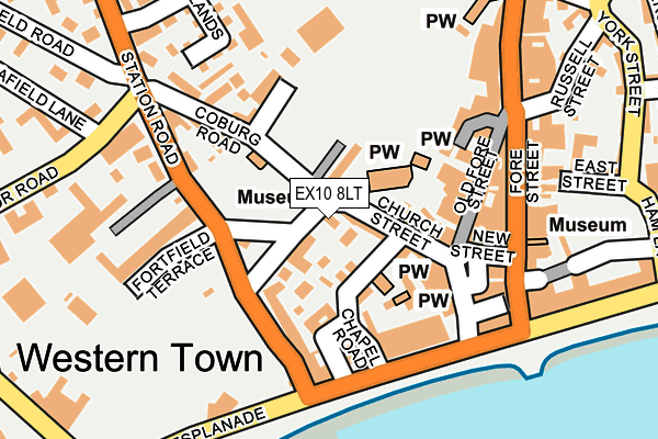
EX10 8LT is located in the Sidmouth Town electoral ward, within the local authority district of East Devon and the English Parliamentary constituency of East Devon. The Sub Integrated Care Board (ICB) Location is NHS Devon ICB - 15N and the police force is Devon & Cornwall. This postcode has been in use since October 1984.


GetTheData
Source: OS OpenMap – Local (Ordnance Survey)
Source: OS VectorMap District (Ordnance Survey)
Licence: Open Government Licence (requires attribution)
| Easting | 312503 |
| Northing | 87336 |
| Latitude | 50.679082 |
| Longitude | -3.239758 |
GetTheData
Source: Open Postcode Geo
Licence: Open Government Licence
| Country | England |
| Postcode District | EX10 |
| ➜ EX10 open data dashboard ➜ See where EX10 is on a map ➜ Where is Sidmouth? | |
GetTheData
Source: Land Registry Price Paid Data
Licence: Open Government Licence
Elevation or altitude of EX10 8LT as distance above sea level:
| Metres | Feet | |
|---|---|---|
| Elevation | 10m | 33ft |
Elevation is measured from the approximate centre of the postcode, to the nearest point on an OS contour line from OS Terrain 50, which has contour spacing of ten vertical metres.
➜ How high above sea level am I? Find the elevation of your current position using your device's GPS.
GetTheData
Source: Open Postcode Elevation
Licence: Open Government Licence
| Ward | Sidmouth Town |
| Constituency | East Devon |
GetTheData
Source: ONS Postcode Database
Licence: Open Government Licence
| August 2022 | Criminal damage and arson | On or near East Street | 243m |
| August 2022 | Anti-social behaviour | On or near East Street | 243m |
| June 2022 | Public order | On or near Chapel Street | 59m |
| ➜ Get more crime data in our Crime section | |||
GetTheData
Source: data.police.uk
Licence: Open Government Licence
| Triangle | Sidmouth | 54m |
| Triangle | Sidmouth | 73m |
| Triangle | Sidmouth | 84m |
| Cypress Terrace (Station Road) | Sidmouth | 305m |
| All Saints Church (All Saints Road) | Sidmouth | 337m |
GetTheData
Source: NaPTAN
Licence: Open Government Licence
GetTheData
Source: ONS Postcode Database
Licence: Open Government Licence


➜ Get more ratings from the Food Standards Agency
GetTheData
Source: Food Standards Agency
Licence: FSA terms & conditions
| Last Collection | |||
|---|---|---|---|
| Location | Mon-Fri | Sat | Distance |
| Triangle | 17:30 | 12:00 | 95m |
| Market Post Office | 18:00 | 12:00 | 135m |
| Esplanade | 18:00 | 12:00 | 218m |
GetTheData
Source: Dracos
Licence: Creative Commons Attribution-ShareAlike
| Facility | Distance |
|---|---|
| Sidmouth Bowling Club Coburg Terrace, Sidmouth Indoor Bowls | 182m |
| Sidmouth Rugby Football Club (Blackmoor Site) Heydons Lane, Sidmouth Grass Pitches | 188m |
| Coburg Fields Tennis Courts Heydons Lane, Sidmouth Outdoor Tennis Courts | 196m |
GetTheData
Source: Active Places
Licence: Open Government Licence
| School | Phase of Education | Distance |
|---|---|---|
| St John's School Broadway, Sidmouth, Devon, Sidmouth, EX10 8RG | Not applicable | 1.1km |
| Sidmouth Church of England (VA) Primary School 55 Woolbrook Road, Sidmouth, EX10 9XB | Primary | 1.7km |
| Sidmouth College Primley Road, Sidmouth, EX10 9LG | Secondary | 2.1km |
GetTheData
Source: Edubase
Licence: Open Government Licence
The below table lists the International Territorial Level (ITL) codes (formerly Nomenclature of Territorial Units for Statistics (NUTS) codes) and Local Administrative Units (LAU) codes for EX10 8LT:
| ITL 1 Code | Name |
|---|---|
| TLK | South West (England) |
| ITL 2 Code | Name |
| TLK4 | Devon |
| ITL 3 Code | Name |
| TLK43 | Devon CC |
| LAU 1 Code | Name |
| E07000040 | East Devon |
GetTheData
Source: ONS Postcode Directory
Licence: Open Government Licence
The below table lists the Census Output Area (OA), Lower Layer Super Output Area (LSOA), and Middle Layer Super Output Area (MSOA) for EX10 8LT:
| Code | Name | |
|---|---|---|
| OA | E00101013 | |
| LSOA | E01019956 | East Devon 012A |
| MSOA | E02004140 | East Devon 012 |
GetTheData
Source: ONS Postcode Directory
Licence: Open Government Licence
| EX10 8PF | The Triangle | 45m |
| EX10 8LY | Church Street | 45m |
| EX10 8ND | Chapel Street | 55m |
| EX10 8PE | Amyatts Terrace | 56m |
| EX10 8NB | Church Street | 76m |
| EX10 8QS | Western Court | 81m |
| EX10 8NA | Church Street | 91m |
| EX10 8LG | Abiff Place | 94m |
| EX10 8NL | Barton Close | 101m |
| EX10 8NE | Bedford Square | 101m |
GetTheData
Source: Open Postcode Geo; Land Registry Price Paid Data
Licence: Open Government Licence