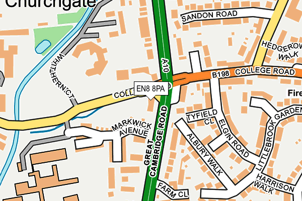
EN8 8PA is located in the Rosedale and Bury Green electoral ward, within the local authority district of Broxbourne and the English Parliamentary constituency of Broxbourne. The Sub Integrated Care Board (ICB) Location is NHS Hertfordshire and West Essex ICB - 06K and the police force is Hertfordshire. This postcode has been in use since January 1980.


GetTheData
Source: OS OpenMap – Local (Ordnance Survey)
Source: OS VectorMap District (Ordnance Survey)
Licence: Open Government Licence (requires attribution)
| Easting | 535298 |
| Northing | 202206 |
| Latitude | 51.702293 |
| Longitude | -0.043508 |
GetTheData
Source: Open Postcode Geo
Licence: Open Government Licence
| Country | England |
| Postcode District | EN8 |
| ➜ EN8 open data dashboard ➜ See where EN8 is on a map ➜ Where is Cheshunt? | |
GetTheData
Source: Land Registry Price Paid Data
Licence: Open Government Licence
Elevation or altitude of EN8 8PA as distance above sea level:
| Metres | Feet | |
|---|---|---|
| Elevation | 30m | 98ft |
Elevation is measured from the approximate centre of the postcode, to the nearest point on an OS contour line from OS Terrain 50, which has contour spacing of ten vertical metres.
➜ How high above sea level am I? Find the elevation of your current position using your device's GPS.
GetTheData
Source: Open Postcode Elevation
Licence: Open Government Licence
| Ward | Rosedale And Bury Green |
| Constituency | Broxbourne |
GetTheData
Source: ONS Postcode Database
Licence: Open Government Licence
| June 2022 | Anti-social behaviour | On or near College Road | 45m |
| June 2022 | Theft from the person | On or near College Road | 45m |
| June 2022 | Criminal damage and arson | On or near Great Cambridge Road | 51m |
| ➜ Get more crime data in our Crime section | |||
GetTheData
Source: data.police.uk
Licence: Open Government Licence
| The Crocodile Ph (College Road) | Cheshunt | 95m |
| Elgin Road (College Road) | Cheshunt | 118m |
| Elgin Road (College Road) | Cheshunt | 170m |
| Bishops' College (College Road) | Cheshunt | 319m |
| Bishops' College (Churchgate) | Cheshunt | 330m |
| Theobalds Grove Station | 1.2km |
| Cheshunt Station | 1.4km |
| Waltham Cross Station | 2.2km |
GetTheData
Source: NaPTAN
Licence: Open Government Licence
GetTheData
Source: ONS Postcode Database
Licence: Open Government Licence


➜ Get more ratings from the Food Standards Agency
GetTheData
Source: Food Standards Agency
Licence: FSA terms & conditions
| Last Collection | |||
|---|---|---|---|
| Location | Mon-Fri | Sat | Distance |
| Council Offices Churchgate | 18:15 | 11:30 | 341m |
| Churchgate | 17:30 | 11:30 | 412m |
| Blindmans Lane | 17:30 | 11:30 | 417m |
GetTheData
Source: Dracos
Licence: Creative Commons Attribution-ShareAlike
| Facility | Distance |
|---|---|
| Goffs - Churchgate Academy College Road, Cheshunt, Waltham Cross Grass Pitches, Sports Hall, Swimming Pool, Artificial Grass Pitch | 259m |
| Target Fitness Albury Ride, Cheshunt, Waltham Cross Health and Fitness Gym, Studio | 494m |
| Cheshunt Community Sports Park Albury Ride, Cheshunt Indoor Bowls, Grass Pitches, Squash Courts, Studio | 514m |
GetTheData
Source: Active Places
Licence: Open Government Licence
| School | Phase of Education | Distance |
|---|---|---|
| Goffs - Churchgate Academy College Road, Cheshunt, Waltham Cross, EN8 9LY | Secondary | 179m |
| Arlesdene Nursery School and Pre-School Blindman's Lane, Cheshunt, Waltham Cross, EN8 9DW | Nursery | 328m |
| Dewhurst St Mary CofE Primary School 94, Churchgate, Cheshunt, Waltham Cross, EN8 9ND | Primary | 461m |
GetTheData
Source: Edubase
Licence: Open Government Licence
The below table lists the International Territorial Level (ITL) codes (formerly Nomenclature of Territorial Units for Statistics (NUTS) codes) and Local Administrative Units (LAU) codes for EN8 8PA:
| ITL 1 Code | Name |
|---|---|
| TLH | East |
| ITL 2 Code | Name |
| TLH2 | Bedfordshire and Hertfordshire |
| ITL 3 Code | Name |
| TLH23 | Hertfordshire CC |
| LAU 1 Code | Name |
| E07000095 | Broxbourne |
GetTheData
Source: ONS Postcode Directory
Licence: Open Government Licence
The below table lists the Census Output Area (OA), Lower Layer Super Output Area (LSOA), and Middle Layer Super Output Area (MSOA) for EN8 8PA:
| Code | Name | |
|---|---|---|
| OA | E00118353 | |
| LSOA | E01023294 | Broxbourne 011B |
| MSOA | E02004853 | Broxbourne 011 |
GetTheData
Source: ONS Postcode Directory
Licence: Open Government Licence
| EN8 8NZ | Great Cambridge Road | 63m |
| EN8 8QP | Tyfield Close | 81m |
| EN8 9LX | College Road | 97m |
| EN8 8NY | Great Cambridge Road | 113m |
| EN8 8QL | Elgin Road | 143m |
| EN8 9NJ | College Court | 145m |
| EN8 8PB | Albury Walk | 158m |
| EN8 9LU | College Road | 160m |
| EN8 8QN | Elgin Road | 163m |
| EN8 8QW | Manston Close | 168m |
GetTheData
Source: Open Postcode Geo; Land Registry Price Paid Data
Licence: Open Government Licence