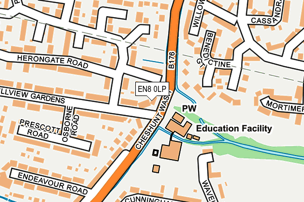
EN8 0LP is located in the Cheshunt North electoral ward, within the local authority district of Broxbourne and the English Parliamentary constituency of Broxbourne. The Sub Integrated Care Board (ICB) Location is NHS Hertfordshire and West Essex ICB - 06K and the police force is Hertfordshire. This postcode has been in use since January 1980.


GetTheData
Source: OS OpenMap – Local (Ordnance Survey)
Source: OS VectorMap District (Ordnance Survey)
Licence: Open Government Licence (requires attribution)
| Easting | 536318 |
| Northing | 203783 |
| Latitude | 51.716222 |
| Longitude | -0.028115 |
GetTheData
Source: Open Postcode Geo
Licence: Open Government Licence
| Country | England |
| Postcode District | EN8 |
➜ See where EN8 is on a map ➜ Where is Cheshunt? | |
GetTheData
Source: Land Registry Price Paid Data
Licence: Open Government Licence
Elevation or altitude of EN8 0LP as distance above sea level:
| Metres | Feet | |
|---|---|---|
| Elevation | 30m | 98ft |
Elevation is measured from the approximate centre of the postcode, to the nearest point on an OS contour line from OS Terrain 50, which has contour spacing of ten vertical metres.
➜ How high above sea level am I? Find the elevation of your current position using your device's GPS.
GetTheData
Source: Open Postcode Elevation
Licence: Open Government Licence
| Ward | Cheshunt North |
| Constituency | Broxbourne |
GetTheData
Source: ONS Postcode Database
Licence: Open Government Licence
| Mayfield School (Cheshunt Wash) | Turnford | 67m |
| Mayfield School (Cheshunt Wash) | Turnford | 154m |
| Mill Lane (Cheshunt Wash) | Cheshunt | 314m |
| Thomas Rochford Way (High Road) | Turnford | 391m |
| Thomas Rochford Way (High Road) | Turnford | 476m |
| Cheshunt Station | 1.5km |
| Theobalds Grove Station | 2.7km |
| Waltham Cross Station | 3.5km |
GetTheData
Source: NaPTAN
Licence: Open Government Licence
| Percentage of properties with Next Generation Access | 100.0% |
| Percentage of properties with Superfast Broadband | 100.0% |
| Percentage of properties with Ultrafast Broadband | 100.0% |
| Percentage of properties with Full Fibre Broadband | 0.0% |
Superfast Broadband is between 30Mbps and 300Mbps
Ultrafast Broadband is > 300Mbps
| Percentage of properties unable to receive 2Mbps | 0.0% |
| Percentage of properties unable to receive 5Mbps | 0.0% |
| Percentage of properties unable to receive 10Mbps | 0.0% |
| Percentage of properties unable to receive 30Mbps | 0.0% |
GetTheData
Source: Ofcom
Licence: Ofcom Terms of Use (requires attribution)
GetTheData
Source: ONS Postcode Database
Licence: Open Government Licence

➜ Get more ratings from the Food Standards Agency
GetTheData
Source: Food Standards Agency
Licence: FSA terms & conditions
| Last Collection | |||
|---|---|---|---|
| Location | Mon-Fri | Sat | Distance |
| Groom Road | 18:00 | 11:30 | 684m |
| East Herts College | 18:00 | 11:30 | 1,069m |
| The Links/Brookfield Farm | 17:30 | 11:30 | 1,085m |
GetTheData
Source: Dracos
Licence: Creative Commons Attribution-ShareAlike
| Risk of EN8 0LP flooding from rivers and sea | Low |
| ➜ EN8 0LP flood map | |
GetTheData
Source: Open Flood Risk by Postcode
Licence: Open Government Licence
The below table lists the International Territorial Level (ITL) codes (formerly Nomenclature of Territorial Units for Statistics (NUTS) codes) and Local Administrative Units (LAU) codes for EN8 0LP:
| ITL 1 Code | Name |
|---|---|
| TLH | East |
| ITL 2 Code | Name |
| TLH2 | Bedfordshire and Hertfordshire |
| ITL 3 Code | Name |
| TLH23 | Hertfordshire CC |
| LAU 1 Code | Name |
| E07000095 | Broxbourne |
GetTheData
Source: ONS Postcode Directory
Licence: Open Government Licence
The below table lists the Census Output Area (OA), Lower Layer Super Output Area (LSOA), and Middle Layer Super Output Area (MSOA) for EN8 0LP:
| Code | Name | |
|---|---|---|
| OA | E00118402 | |
| LSOA | E01023306 | Broxbourne 008E |
| MSOA | E02004850 | Broxbourne 008 |
GetTheData
Source: ONS Postcode Directory
Licence: Open Government Licence
| EN8 0TS | Perrysfield Road | 39m |
| EN8 0PD | Hillview Gardens | 40m |
| EN8 0TT | Perrysfield Road | 100m |
| EN8 0PE | Hillview Gardens | 116m |
| EN8 0TR | Perrysfield Road | 119m |
| EN8 0LW | Cheshunt Wash | 135m |
| EN8 0XB | Benedictine Gate | 136m |
| EN8 0LR | Cheshunt Wash | 164m |
| EN8 0PG | Prescott Road | 187m |
| EN8 0JZ | Wavell Close | 193m |
GetTheData
Source: Open Postcode Geo; Land Registry Price Paid Data
Licence: Open Government Licence