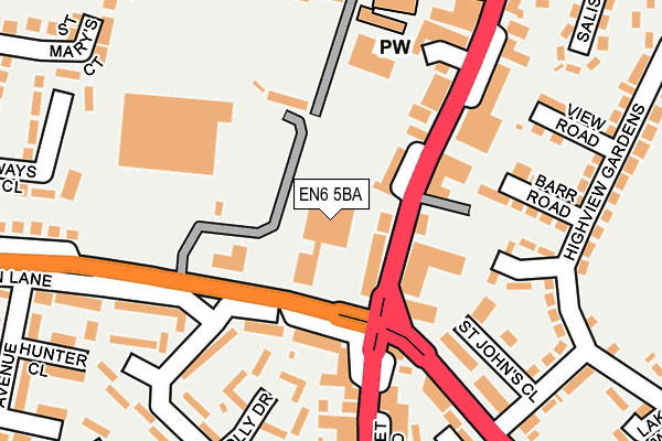
EN6 5BA is located in the Potters Bar Parkfield electoral ward, within the local authority district of Hertsmere and the English Parliamentary constituency of Hertsmere. The Sub Integrated Care Board (ICB) Location is NHS Hertfordshire and West Essex ICB - 06N and the police force is Hertfordshire. This postcode has been in use since January 1980.


GetTheData
Source: OS OpenMap – Local (Ordnance Survey)
Source: OS VectorMap District (Ordnance Survey)
Licence: Open Government Licence (requires attribution)
| Easting | 525941 |
| Northing | 200950 |
| Latitude | 51.693182 |
| Longitude | -0.179289 |
GetTheData
Source: Open Postcode Geo
Licence: Open Government Licence
| Country | England |
| Postcode District | EN6 |
| ➜ EN6 open data dashboard ➜ See where EN6 is on a map ➜ Where is Potters Bar? | |
GetTheData
Source: Land Registry Price Paid Data
Licence: Open Government Licence
Elevation or altitude of EN6 5BA as distance above sea level:
| Metres | Feet | |
|---|---|---|
| Elevation | 120m | 394ft |
Elevation is measured from the approximate centre of the postcode, to the nearest point on an OS contour line from OS Terrain 50, which has contour spacing of ten vertical metres.
➜ How high above sea level am I? Find the elevation of your current position using your device's GPS.
GetTheData
Source: Open Postcode Elevation
Licence: Open Government Licence
| Ward | Potters Bar Parkfield |
| Constituency | Hertsmere |
GetTheData
Source: ONS Postcode Database
Licence: Open Government Licence
| January 2024 | Public order | On or near Petrol Station | 110m |
| January 2024 | Other theft | On or near Petrol Station | 131m |
| January 2024 | Public order | On or near Petrol Station | 131m |
| ➜ Get more crime data in our Crime section | |||
GetTheData
Source: data.police.uk
Licence: Open Government Licence
| Cask & Stillage Ph (High Street) | Potters Bar | 72m |
| Cask & Stillage Ph (High Street) | Potters Bar | 86m |
| Whaley Road (Barnet Road) | Potters Bar | 176m |
| Tesco (Mutton Lane) | Potters Bar | 197m |
| Tesco (Mutton Lane) | Potters Bar | 201m |
| Potters Bar Station | 1km |
| Hadley Wood Station | 2.8km |
| Brookmans Park Station | 3.6km |
GetTheData
Source: NaPTAN
Licence: Open Government Licence
Estimated total energy consumption in EN6 5BA by fuel type, 2015.
| Consumption (kWh) | 159,501 |
|---|---|
| Meter count | 6 |
| Mean (kWh/meter) | 26,584 |
| Median (kWh/meter) | 26,199 |
GetTheData
Source: Postcode level gas estimates: 2015 (experimental)
Source: Postcode level electricity estimates: 2015 (experimental)
Licence: Open Government Licence
GetTheData
Source: ONS Postcode Database
Licence: Open Government Licence

➜ Get more ratings from the Food Standards Agency
GetTheData
Source: Food Standards Agency
Licence: FSA terms & conditions
| Last Collection | |||
|---|---|---|---|
| Location | Mon-Fri | Sat | Distance |
| Mutton Lane | 103m | ||
| High Street | 18:30 | 12:00 | 247m |
| Willow Way | 17:30 | 12:00 | 383m |
GetTheData
Source: Dracos
Licence: Creative Commons Attribution-ShareAlike
| Facility | Distance |
|---|---|
| Potters Bar Cricket Club The Walk, Potters Bar Grass Pitches | 281m |
| Potters Bar Lawn Tennis Club The Walk, Potters Bar Outdoor Tennis Courts | 292m |
| Potters Bar Town Fc Warkins Rise, The Walk, Potters Bar Grass Pitches | 359m |
GetTheData
Source: Active Places
Licence: Open Government Licence
| School | Phase of Education | Distance |
|---|---|---|
| Ladbrooke Junior Mixed and Infant School Watkins Rise, Potters Bar, EN6 1QB | Primary | 362m |
| Elysium Healthcare Potters Bar Clinic School Barnet Road, Potters Bar, Hertfordshire, Potters Bar, EN6 2SE | Not applicable | 747m |
| Cambian Walnut Tree Lodge School Renhold Road, Wilden, Bedford, MK44 2PT | Not applicable | 932m |
GetTheData
Source: Edubase
Licence: Open Government Licence
The below table lists the International Territorial Level (ITL) codes (formerly Nomenclature of Territorial Units for Statistics (NUTS) codes) and Local Administrative Units (LAU) codes for EN6 5BA:
| ITL 1 Code | Name |
|---|---|
| TLH | East |
| ITL 2 Code | Name |
| TLH2 | Bedfordshire and Hertfordshire |
| ITL 3 Code | Name |
| TLH23 | Hertfordshire CC |
| LAU 1 Code | Name |
| E07000098 | Hertsmere |
GetTheData
Source: ONS Postcode Directory
Licence: Open Government Licence
The below table lists the Census Output Area (OA), Lower Layer Super Output Area (LSOA), and Middle Layer Super Output Area (MSOA) for EN6 5BA:
| Code | Name | |
|---|---|---|
| OA | E00119751 | |
| LSOA | E01023580 | Hertsmere 001E |
| MSOA | E02004896 | Hertsmere 001 |
GetTheData
Source: ONS Postcode Directory
Licence: Open Government Licence
| EN6 2PA | Mutton Lane | 109m |
| EN6 5AJ | High Street | 122m |
| EN6 5PF | Highview Close | 160m |
| EN6 2QL | Holly Drive | 163m |
| EN6 5PD | St Johns Close | 163m |
| EN6 2QX | Barnet Road | 169m |
| EN6 5PG | Barr Road | 170m |
| EN6 5AB | High Street | 172m |
| EN6 5DR | Southgate Road | 183m |
| EN6 2PQ | Ashwood Road | 189m |
GetTheData
Source: Open Postcode Geo; Land Registry Price Paid Data
Licence: Open Government Licence