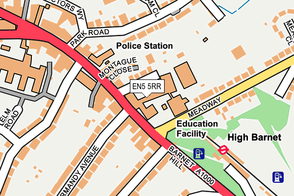
EN5 5RR is located in the Barnet Vale electoral ward, within the London borough of Barnet and the English Parliamentary constituency of Chipping Barnet. The Sub Integrated Care Board (ICB) Location is NHS North Central London ICB - 93C and the police force is Metropolitan Police. This postcode has been in use since January 1980.


GetTheData
Source: OS OpenMap – Local (Ordnance Survey)
Source: OS VectorMap District (Ordnance Survey)
Licence: Open Government Licence (requires attribution)
| Easting | 524851 |
| Northing | 196320 |
| Latitude | 51.651820 |
| Longitude | -0.196679 |
GetTheData
Source: Open Postcode Geo
Licence: Open Government Licence
| Country | England |
| Postcode District | EN5 |
| ➜ EN5 open data dashboard ➜ See where EN5 is on a map ➜ Where is Barnet? | |
GetTheData
Source: Land Registry Price Paid Data
Licence: Open Government Licence
Elevation or altitude of EN5 5RR as distance above sea level:
| Metres | Feet | |
|---|---|---|
| Elevation | 120m | 394ft |
Elevation is measured from the approximate centre of the postcode, to the nearest point on an OS contour line from OS Terrain 50, which has contour spacing of ten vertical metres.
➜ How high above sea level am I? Find the elevation of your current position using your device's GPS.
GetTheData
Source: Open Postcode Elevation
Licence: Open Government Licence
| Ward | Barnet Vale |
| Constituency | Chipping Barnet |
GetTheData
Source: ONS Postcode Database
Licence: Open Government Licence
| January 2024 | Other theft | On or near Moxon Street | 317m |
| October 2023 | Anti-social behaviour | On or near Moxon Street | 317m |
| October 2023 | Other theft | On or near Moxon Street | 317m |
| ➜ Get more crime data in our Crime section | |||
GetTheData
Source: data.police.uk
Licence: Open Government Licence
| High Barnet Station Meadway (Barnet High Street) | Barnet | 52m |
| High Barnet (Meadway) | Barnet | 78m |
| Fitzjohn Avenue (Barnet High Street) | Barnet | 137m |
| Barnet High St Barnet Church (Barnet High Street) | Barnet | 171m |
| Barnet Church (Barnet High Street) | Barnet | 185m |
| High Barnet Underground Station | Barnet | 219m |
| New Barnet Station | 1.7km |
| Hadley Wood Station | 2.3km |
| Oakleigh Park Station | 2.6km |
GetTheData
Source: NaPTAN
Licence: Open Government Licence
GetTheData
Source: ONS Postcode Database
Licence: Open Government Licence


➜ Get more ratings from the Food Standards Agency
GetTheData
Source: Food Standards Agency
Licence: FSA terms & conditions
| Last Collection | |||
|---|---|---|---|
| Location | Mon-Fri | Sat | Distance |
| Meadway | 17:30 | 12:00 | 69m |
| Normandy Avenue | 17:30 | 12:00 | 194m |
| Park Road | 18:45 | 12:00 | 195m |
GetTheData
Source: Dracos
Licence: Creative Commons Attribution-ShareAlike
| Facility | Distance |
|---|---|
| Queen Elizabeth Sports Centre Meadway, Barnet Sports Hall, Health and Fitness Gym, Swimming Pool, Outdoor Tennis Courts | 60m |
| St Catherines Catholic Primary School Vale Drive, Barnet Grass Pitches | 396m |
| Anytime Fitness (London High Barnet) High Street, Barnet Health and Fitness Gym, Studio | 533m |
GetTheData
Source: Active Places
Licence: Open Government Licence
| School | Phase of Education | Distance |
|---|---|---|
| Queen Elizabeth's Girls' School High Street, Barnet, EN5 5RR | Secondary | 8m |
| Susi Earnshaw Theatre School 68 High Street, Barnet, EN5 5SJ | Not applicable | 277m |
| Barnet and Southgate College Wood Street, Barnet, EN5 4AZ | 16 plus | 280m |
GetTheData
Source: Edubase
Licence: Open Government Licence
The below table lists the International Territorial Level (ITL) codes (formerly Nomenclature of Territorial Units for Statistics (NUTS) codes) and Local Administrative Units (LAU) codes for EN5 5RR:
| ITL 1 Code | Name |
|---|---|
| TLI | London |
| ITL 2 Code | Name |
| TLI7 | Outer London - West and North West |
| ITL 3 Code | Name |
| TLI71 | Barnet |
| LAU 1 Code | Name |
| E09000003 | Barnet |
GetTheData
Source: ONS Postcode Directory
Licence: Open Government Licence
The below table lists the Census Output Area (OA), Lower Layer Super Output Area (LSOA), and Middle Layer Super Output Area (MSOA) for EN5 5RR:
| Code | Name | |
|---|---|---|
| OA | E00001235 | |
| LSOA | E01000250 | Barnet 001C |
| MSOA | E02000024 | Barnet 001 |
GetTheData
Source: ONS Postcode Directory
Licence: Open Government Licence
| EN5 5RS | Gordon Way | 49m |
| EN5 5RT | High Street | 63m |
| EN5 5RW | Montague Close | 75m |
| EN5 5RZ | Montague Close | 77m |
| EN5 2HZ | Normandy Avenue | 78m |
| EN5 5UH | High Street | 78m |
| EN5 5UE | High Street | 84m |
| EN5 2HY | Normandy Avenue | 94m |
| EN5 5UJ | High Street | 98m |
| EN5 5RU | High Street | 107m |
GetTheData
Source: Open Postcode Geo; Land Registry Price Paid Data
Licence: Open Government Licence