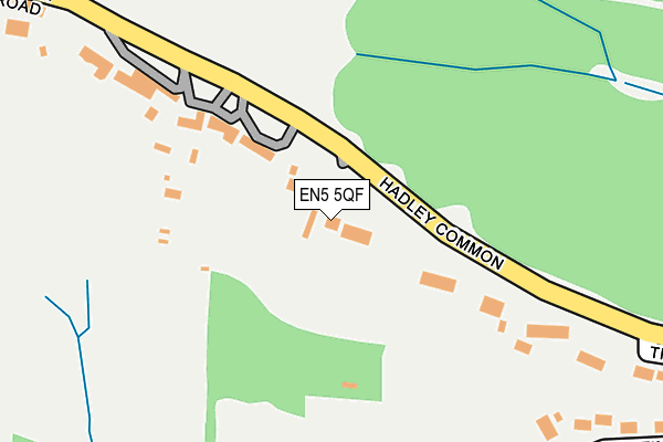
EN5 5QF lies on Hadley Hurst Cottages in Barnet. EN5 5QF is located in the High Barnet electoral ward, within the London borough of Barnet and the English Parliamentary constituency of Chipping Barnet. The Sub Integrated Care Board (ICB) Location is NHS North Central London ICB - 93C and the police force is Metropolitan Police. This postcode has been in use since January 1980.


GetTheData
Source: OS OpenMap – Local (Ordnance Survey)
Source: OS VectorMap District (Ordnance Survey)
Licence: Open Government Licence (requires attribution)
| Easting | 525305 |
| Northing | 197149 |
| Latitude | 51.659169 |
| Longitude | -0.189823 |
GetTheData
Source: Open Postcode Geo
Licence: Open Government Licence
| Street | Hadley Hurst Cottages |
| Town/City | Barnet |
| Country | England |
| Postcode District | EN5 |
| ➜ EN5 open data dashboard ➜ See where EN5 is on a map ➜ Where is London? | |
GetTheData
Source: Land Registry Price Paid Data
Licence: Open Government Licence
Elevation or altitude of EN5 5QF as distance above sea level:
| Metres | Feet | |
|---|---|---|
| Elevation | 120m | 394ft |
Elevation is measured from the approximate centre of the postcode, to the nearest point on an OS contour line from OS Terrain 50, which has contour spacing of ten vertical metres.
➜ How high above sea level am I? Find the elevation of your current position using your device's GPS.
GetTheData
Source: Open Postcode Elevation
Licence: Open Government Licence
| Ward | High Barnet |
| Constituency | Chipping Barnet |
GetTheData
Source: ONS Postcode Database
Licence: Open Government Licence
| May 2022 | Vehicle crime | On or near Latimer Road | 392m |
| April 2022 | Vehicle crime | On or near Hurst Rise | 419m |
| April 2022 | Vehicle crime | On or near Hurst Rise | 419m |
| ➜ Get more crime data in our Crime section | |||
GetTheData
Source: data.police.uk
Licence: Open Government Licence
| Monken Hadley Coe School | Monken Hadley | 371m |
| Monken Hadley Coe School | Monken Hadley | 371m |
| Monken Hadley Church | Monken Hadley | 393m |
| Monken Hadley Church | Monken Hadley | 404m |
| Monken Hadley Church | Monken Hadley | 428m |
| High Barnet Underground Station | Barnet | 1,008m |
| Hadley Wood Station | 1.4km |
| New Barnet Station | 1.7km |
| Oakleigh Park Station | 2.9km |
GetTheData
Source: NaPTAN
Licence: Open Government Licence
| Percentage of properties with Next Generation Access | 100.0% |
| Percentage of properties with Superfast Broadband | 100.0% |
| Percentage of properties with Ultrafast Broadband | 0.0% |
| Percentage of properties with Full Fibre Broadband | 0.0% |
Superfast Broadband is between 30Mbps and 300Mbps
Ultrafast Broadband is > 300Mbps
| Percentage of properties unable to receive 2Mbps | 0.0% |
| Percentage of properties unable to receive 5Mbps | 0.0% |
| Percentage of properties unable to receive 10Mbps | 0.0% |
| Percentage of properties unable to receive 30Mbps | 0.0% |
GetTheData
Source: Ofcom
Licence: Ofcom Terms of Use (requires attribution)
GetTheData
Source: ONS Postcode Database
Licence: Open Government Licence


➜ Get more ratings from the Food Standards Agency
GetTheData
Source: Food Standards Agency
Licence: FSA terms & conditions
| Last Collection | |||
|---|---|---|---|
| Location | Mon-Fri | Sat | Distance |
| The Cresent | 17:30 | 12:00 | 352m |
| Hadley Church | 17:30 | 12:00 | 381m |
| Tudor Road | 17:30 | 12:00 | 644m |
GetTheData
Source: Dracos
Licence: Creative Commons Attribution-ShareAlike
| Facility | Distance |
|---|---|
| Monken Hadley Cricket Club Hadley Common, Camlet Way, Hadley Grass Pitches | 260m |
| Mount House School Camlet Way, Barnet Sports Hall | 456m |
| Tudor Park (Closed) Clifford Road, Barnet Golf, Outdoor Tennis Courts | 690m |
GetTheData
Source: Active Places
Licence: Open Government Licence
| School | Phase of Education | Distance |
|---|---|---|
| Monken Hadley CofE Primary School Camlet Way, Monken Hadley, Barnet, EN4 0NJ | Primary | 420m |
| Mount House School Camlet Way, Hadley, Barnet, EN4 0NJ | Not applicable | 456m |
| Queen Elizabeth's Girls' School High Street, Barnet, EN5 5RR | Secondary | 953m |
GetTheData
Source: Edubase
Licence: Open Government Licence
The below table lists the International Territorial Level (ITL) codes (formerly Nomenclature of Territorial Units for Statistics (NUTS) codes) and Local Administrative Units (LAU) codes for EN5 5QF:
| ITL 1 Code | Name |
|---|---|
| TLI | London |
| ITL 2 Code | Name |
| TLI7 | Outer London - West and North West |
| ITL 3 Code | Name |
| TLI71 | Barnet |
| LAU 1 Code | Name |
| E09000003 | Barnet |
GetTheData
Source: ONS Postcode Directory
Licence: Open Government Licence
The below table lists the Census Output Area (OA), Lower Layer Super Output Area (LSOA), and Middle Layer Super Output Area (MSOA) for EN5 5QF:
| Code | Name | |
|---|---|---|
| OA | E00001216 | |
| LSOA | E01000246 | Barnet 002B |
| MSOA | E02000025 | Barnet 002 |
GetTheData
Source: ONS Postcode Directory
Licence: Open Government Licence
| EN5 5QE | Hadley Common | 134m |
| EN5 5QG | Hadley Common | 166m |
| EN5 5NU | Latimer Road | 349m |
| EN5 5NP | Tudor Road | 379m |
| EN5 5QB | Church Cottages | 396m |
| EN5 5QQ | The Crescent | 402m |
| EN5 5NR | Vincent Close | 409m |
| EN4 0NH | Camlet Way | 413m |
| EN5 5NW | Tudor Road | 417m |
| EN5 5PY | Hadley Green Road | 424m |
GetTheData
Source: Open Postcode Geo; Land Registry Price Paid Data
Licence: Open Government Licence