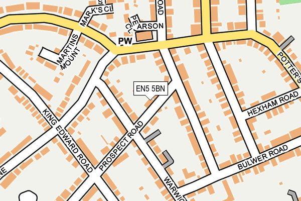
EN5 5BN lies on Prospect Road in Barnet. EN5 5BN is located in the Barnet Vale electoral ward, within the London borough of Barnet and the English Parliamentary constituency of Chipping Barnet. The Sub Integrated Care Board (ICB) Location is NHS North Central London ICB - 93C and the police force is Metropolitan Police. This postcode has been in use since January 1980.


GetTheData
Source: OS OpenMap – Local (Ordnance Survey)
Source: OS VectorMap District (Ordnance Survey)
Licence: Open Government Licence (requires attribution)
| Easting | 525674 |
| Northing | 196352 |
| Latitude | 51.651924 |
| Longitude | -0.184778 |
GetTheData
Source: Open Postcode Geo
Licence: Open Government Licence
| Street | Prospect Road |
| Town/City | Barnet |
| Country | England |
| Postcode District | EN5 |
| ➜ EN5 open data dashboard ➜ See where EN5 is on a map ➜ Where is Barnet? | |
GetTheData
Source: Land Registry Price Paid Data
Licence: Open Government Licence
Elevation or altitude of EN5 5BN as distance above sea level:
| Metres | Feet | |
|---|---|---|
| Elevation | 80m | 262ft |
Elevation is measured from the approximate centre of the postcode, to the nearest point on an OS contour line from OS Terrain 50, which has contour spacing of ten vertical metres.
➜ How high above sea level am I? Find the elevation of your current position using your device's GPS.
GetTheData
Source: Open Postcode Elevation
Licence: Open Government Licence
| Ward | Barnet Vale |
| Constituency | Chipping Barnet |
GetTheData
Source: ONS Postcode Database
Licence: Open Government Licence
| January 2024 | Other theft | On or near Bosworth Road | 307m |
| January 2024 | Other theft | On or near Bosworth Road | 307m |
| December 2023 | Criminal damage and arson | On or near Woodville Road | 213m |
| ➜ Prospect Road crime map and outcomes | |||
GetTheData
Source: data.police.uk
Licence: Open Government Licence
| Hadley Road (En5) | New Barnet | 146m |
| St Marks Close (Meadway) | Hadley | 193m |
| St Marks Close (Meadway) | Hadley | 222m |
| Clifford Road (En5) (Potter's Road) | New Barnet | 282m |
| King Edward Road (En5) (Meadway) | Hadley | 364m |
| High Barnet Underground Station | Barnet | 675m |
| New Barnet Station | 0.9km |
| Hadley Wood Station | 1.9km |
| Oakleigh Park Station | 2km |
GetTheData
Source: NaPTAN
Licence: Open Government Licence
| Percentage of properties with Next Generation Access | 100.0% |
| Percentage of properties with Superfast Broadband | 100.0% |
| Percentage of properties with Ultrafast Broadband | 100.0% |
| Percentage of properties with Full Fibre Broadband | 100.0% |
Superfast Broadband is between 30Mbps and 300Mbps
Ultrafast Broadband is > 300Mbps
| Percentage of properties unable to receive 2Mbps | 0.0% |
| Percentage of properties unable to receive 5Mbps | 0.0% |
| Percentage of properties unable to receive 10Mbps | 0.0% |
| Percentage of properties unable to receive 30Mbps | 0.0% |
GetTheData
Source: Ofcom
Licence: Ofcom Terms of Use (requires attribution)
GetTheData
Source: ONS Postcode Database
Licence: Open Government Licence


➜ Get more ratings from the Food Standards Agency
GetTheData
Source: Food Standards Agency
Licence: FSA terms & conditions
| Last Collection | |||
|---|---|---|---|
| Location | Mon-Fri | Sat | Distance |
| King Edward Street | 17:30 | 12:00 | 214m |
| Warwick Road | 17:30 | 12:00 | 312m |
| Bulwer Road P.o | 18:30 | 12:00 | 340m |
GetTheData
Source: Dracos
Licence: Creative Commons Attribution-ShareAlike
| Facility | Distance |
|---|---|
| Cromer Road Primary School Cromer Road, New Barnet, Barnet Swimming Pool, Grass Pitches | 449m |
| Tudor Park (Closed) Clifford Road, Barnet Golf, Outdoor Tennis Courts | 543m |
| Barnet Lawn Tennis Club Gloucester Road, Barnet Outdoor Tennis Courts | 596m |
GetTheData
Source: Active Places
Licence: Open Government Licence
| School | Phase of Education | Distance |
|---|---|---|
| Cromer Road Primary School Cromer Road, New Barnet, Barnet, EN5 5HT | Primary | 460m |
| Lyonsdown School 3 Richmond Road, New Barnet, EN5 1SA | Not applicable | 683m |
| St Catherine's RC School Vale Drive, Barnet, EN5 2ED | Primary | 708m |
GetTheData
Source: Edubase
Licence: Open Government Licence
The below table lists the International Territorial Level (ITL) codes (formerly Nomenclature of Territorial Units for Statistics (NUTS) codes) and Local Administrative Units (LAU) codes for EN5 5BN:
| ITL 1 Code | Name |
|---|---|
| TLI | London |
| ITL 2 Code | Name |
| TLI7 | Outer London - West and North West |
| ITL 3 Code | Name |
| TLI71 | Barnet |
| LAU 1 Code | Name |
| E09000003 | Barnet |
GetTheData
Source: ONS Postcode Directory
Licence: Open Government Licence
The below table lists the Census Output Area (OA), Lower Layer Super Output Area (LSOA), and Middle Layer Super Output Area (MSOA) for EN5 5BN:
| Code | Name | |
|---|---|---|
| OA | E00001243 | |
| LSOA | E01000252 | Barnet 002E |
| MSOA | E02000025 | Barnet 002 |
GetTheData
Source: ONS Postcode Directory
Licence: Open Government Licence
| EN5 5BP | Prospect Road | 27m |
| EN5 5BW | Prospect Road | 46m |
| EN5 5ER | Warwick Road | 47m |
| EN5 5HE | Woodville Road | 52m |
| EN5 5HZ | Woodville Road | 62m |
| EN5 5EH | Warwick Road | 66m |
| EN5 5HB | Woodville Road | 76m |
| EN5 5HF | Potters Road | 97m |
| EN5 5EJ | Warwick Road | 98m |
| EN5 5ED | Warwick Road | 99m |
GetTheData
Source: Open Postcode Geo; Land Registry Price Paid Data
Licence: Open Government Licence