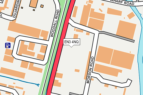
EN3 4NQ lies on Riverside Industrial Estate in Enfield. EN3 4NQ is located in the Ponders End electoral ward, within the London borough of Enfield and the English Parliamentary constituency of Edmonton. The Sub Integrated Care Board (ICB) Location is NHS North Central London ICB - 93C and the police force is Metropolitan Police. This postcode has been in use since September 1991.


GetTheData
Source: OS OpenMap – Local (Ordnance Survey)
Source: OS VectorMap District (Ordnance Survey)
Licence: Open Government Licence (requires attribution)
| Easting | 536127 |
| Northing | 195326 |
| Latitude | 51.640272 |
| Longitude | -0.034172 |
GetTheData
Source: Open Postcode Geo
Licence: Open Government Licence
| Street | Riverside Industrial Estate |
| Town/City | Enfield |
| Country | England |
| Postcode District | EN3 |
| ➜ EN3 open data dashboard ➜ See where EN3 is on a map ➜ Where is London? | |
GetTheData
Source: Land Registry Price Paid Data
Licence: Open Government Licence
Elevation or altitude of EN3 4NQ as distance above sea level:
| Metres | Feet | |
|---|---|---|
| Elevation | 20m | 66ft |
Elevation is measured from the approximate centre of the postcode, to the nearest point on an OS contour line from OS Terrain 50, which has contour spacing of ten vertical metres.
➜ How high above sea level am I? Find the elevation of your current position using your device's GPS.
GetTheData
Source: Open Postcode Elevation
Licence: Open Government Licence
| Ward | Ponders End |
| Constituency | Edmonton |
GetTheData
Source: ONS Postcode Database
Licence: Open Government Licence
| June 2022 | Violence and sexual offences | On or near Woodall Road | 142m |
| June 2022 | Anti-social behaviour | On or near Woodall Road | 142m |
| June 2022 | Other theft | On or near Meridian Way | 158m |
| ➜ Get more crime data in our Crime section | |||
GetTheData
Source: data.police.uk
Licence: Open Government Licence
| Ponders End (Alma Road) | Ponders End | 289m |
| Ponders End | Ponders End | 323m |
| Oasis Academy Hadley | Ponders End | 374m |
| Wharf Road | Ponders End | 417m |
| Wharf Road | Ponders End | 464m |
| Ponders End Station | 0.2km |
| Southbury Station | 1.6km |
| Brimsdown Station | 1.7km |
GetTheData
Source: NaPTAN
Licence: Open Government Licence
| Median download speed | 11.4Mbps |
| Average download speed | 9.8Mbps |
| Maximum download speed | 14.32Mbps |
| Median upload speed | 0.9Mbps |
| Average upload speed | 0.9Mbps |
| Maximum upload speed | 1.15Mbps |
GetTheData
Source: Ofcom
Licence: Ofcom Terms of Use (requires attribution)
GetTheData
Source: ONS Postcode Database
Licence: Open Government Licence

➜ Get more ratings from the Food Standards Agency
GetTheData
Source: Food Standards Agency
Licence: FSA terms & conditions
| Last Collection | |||
|---|---|---|---|
| Location | Mon-Fri | Sat | Distance |
| Scotland Green Road | 17:30 | 12:00 | 742m |
| Northfield Road | 17:30 | 12:00 | 1,200m |
| Southbury Road | 17:30 | 12:00 | 1,258m |
GetTheData
Source: Dracos
Licence: Creative Commons Attribution-ShareAlike
| Facility | Distance |
|---|---|
| Oasis Academy Hadley South Street, Enfield Health and Fitness Gym, Studio, Sports Hall, Artificial Grass Pitch | 259m |
| Salisbury School (Nightingale Road Campus) (Closed) Nightingale Road, Edmonton, London Sports Hall | 810m |
| Lee Valley Leisure Golf Course Meridian Way, London Golf | 900m |
GetTheData
Source: Active Places
Licence: Open Government Licence
| School | Phase of Education | Distance |
|---|---|---|
| Oasis Academy Hadley 143 South Street, Enfield, EN3 4PX | All-through | 368m |
| Alma Primary School Alma Road, Ponders End, Enfield, EN3 4UQ | Primary | 491m |
| St Matthew's CofE Primary School St Matthew's C of E Primary School, South Street, Enfield, EN3 4LA | Primary | 754m |
GetTheData
Source: Edubase
Licence: Open Government Licence
The below table lists the International Territorial Level (ITL) codes (formerly Nomenclature of Territorial Units for Statistics (NUTS) codes) and Local Administrative Units (LAU) codes for EN3 4NQ:
| ITL 1 Code | Name |
|---|---|
| TLI | London |
| ITL 2 Code | Name |
| TLI5 | Outer London - East and North East |
| ITL 3 Code | Name |
| TLI54 | Enfield |
| LAU 1 Code | Name |
| E09000010 | Enfield |
GetTheData
Source: ONS Postcode Directory
Licence: Open Government Licence
The below table lists the Census Output Area (OA), Lower Layer Super Output Area (LSOA), and Middle Layer Super Output Area (MSOA) for EN3 4NQ:
| Code | Name | |
|---|---|---|
| OA | E00007465 | |
| LSOA | E01001510 | Enfield 014D |
| MSOA | E02000290 | Enfield 014 |
GetTheData
Source: ONS Postcode Directory
Licence: Open Government Licence
| EN3 4TA | Wharf Road | 142m |
| EN3 4PY | South Street | 295m |
| EN3 4LE | Redburn Industrial Estate | 331m |
| N9 8BD | Sandhurst Road | 380m |
| EN3 4LT | Falcon Crescent | 410m |
| EN3 4UG | Alma Road | 414m |
| N9 8BE | Sandhurst Road | 426m |
| EN3 4UF | Curzon Avenue | 440m |
| EN3 4QP | Napier Road | 441m |
| EN3 4QA | South Street | 451m |
GetTheData
Source: Open Postcode Geo; Land Registry Price Paid Data
Licence: Open Government Licence