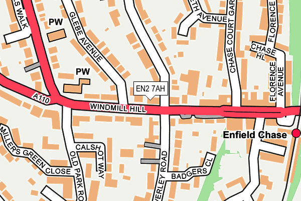
EN2 7AH lies on Windmill Hill in Enfield. EN2 7AH is located in the Ridgeway electoral ward, within the London borough of Enfield and the English Parliamentary constituency of Enfield North. The Sub Integrated Care Board (ICB) Location is NHS North Central London ICB - 93C and the police force is Metropolitan Police. This postcode has been in use since January 1980.


GetTheData
Source: OS OpenMap – Local (Ordnance Survey)
Source: OS VectorMap District (Ordnance Survey)
Licence: Open Government Licence (requires attribution)
| Easting | 531888 |
| Northing | 196726 |
| Latitude | 51.653860 |
| Longitude | -0.094892 |
GetTheData
Source: Open Postcode Geo
Licence: Open Government Licence
| Street | Windmill Hill |
| Town/City | Enfield |
| Country | England |
| Postcode District | EN2 |
| ➜ EN2 open data dashboard ➜ See where EN2 is on a map ➜ Where is London? | |
GetTheData
Source: Land Registry Price Paid Data
Licence: Open Government Licence
Elevation or altitude of EN2 7AH as distance above sea level:
| Metres | Feet | |
|---|---|---|
| Elevation | 60m | 197ft |
Elevation is measured from the approximate centre of the postcode, to the nearest point on an OS contour line from OS Terrain 50, which has contour spacing of ten vertical metres.
➜ How high above sea level am I? Find the elevation of your current position using your device's GPS.
GetTheData
Source: Open Postcode Elevation
Licence: Open Government Licence
| Ward | Ridgeway |
| Constituency | Enfield North |
GetTheData
Source: ONS Postcode Database
Licence: Open Government Licence
| January 2024 | Violence and sexual offences | On or near Badgers Close | 161m |
| January 2024 | Criminal damage and arson | On or near Millers Green Close | 259m |
| January 2024 | Vehicle crime | On or near Millers Green Close | 259m |
| ➜ Get more crime data in our Crime section | |||
GetTheData
Source: data.police.uk
Licence: Open Government Licence
| The Ridgeway (En2) | Grange Park | 120m |
| The Ridgeway Slades Hill | Grange Park | 186m |
| Slades Hill (The Ridgeway) | Town | 249m |
| Enfield Chase | Enfield Town | 267m |
| Enfield Chase (Windmill Hill) | Enfield Town | 326m |
| Enfield Chase Station | 0.3km |
| Gordon Hill Station | 1.1km |
| Enfield Town Station | 1.1km |
GetTheData
Source: NaPTAN
Licence: Open Government Licence
| Percentage of properties with Next Generation Access | 100.0% |
| Percentage of properties with Superfast Broadband | 100.0% |
| Percentage of properties with Ultrafast Broadband | 100.0% |
| Percentage of properties with Full Fibre Broadband | 0.0% |
Superfast Broadband is between 30Mbps and 300Mbps
Ultrafast Broadband is > 300Mbps
| Percentage of properties unable to receive 2Mbps | 0.0% |
| Percentage of properties unable to receive 5Mbps | 0.0% |
| Percentage of properties unable to receive 10Mbps | 0.0% |
| Percentage of properties unable to receive 30Mbps | 0.0% |
GetTheData
Source: Ofcom
Licence: Ofcom Terms of Use (requires attribution)
GetTheData
Source: ONS Postcode Database
Licence: Open Government Licence


➜ Get more ratings from the Food Standards Agency
GetTheData
Source: Food Standards Agency
Licence: FSA terms & conditions
| Last Collection | |||
|---|---|---|---|
| Location | Mon-Fri | Sat | Distance |
| Windmill Hill | 17:30 | 12:00 | 135m |
| The Ridgeway | 17:30 | 12:00 | 234m |
| Old Park View | 17:30 | 12:00 | 359m |
GetTheData
Source: Dracos
Licence: Creative Commons Attribution-ShareAlike
| Facility | Distance |
|---|---|
| Lux Fitness Old Park Avenue, Enfield Health and Fitness Gym | 422m |
| Town Park Playing Fields Cecil Road, Enfield Grass Pitches, Outdoor Tennis Courts | 613m |
| Enfield Golf Club Limited Old Park Road South, Enfield Golf | 633m |
GetTheData
Source: Active Places
Licence: Open Government Licence
| School | Phase of Education | Distance |
|---|---|---|
| Chase Side Primary School Trinity Street, Enfield, EN2 6NS | Primary | 692m |
| Enfield County School for Girls Holly Walk, Enfield, EN2 6QG | Secondary | 774m |
| Enfield Grammar School Market Place, Enfield, EN2 6LN | Secondary | 815m |
GetTheData
Source: Edubase
Licence: Open Government Licence
The below table lists the International Territorial Level (ITL) codes (formerly Nomenclature of Territorial Units for Statistics (NUTS) codes) and Local Administrative Units (LAU) codes for EN2 7AH:
| ITL 1 Code | Name |
|---|---|
| TLI | London |
| ITL 2 Code | Name |
| TLI5 | Outer London - East and North East |
| ITL 3 Code | Name |
| TLI54 | Enfield |
| LAU 1 Code | Name |
| E09000010 | Enfield |
GetTheData
Source: ONS Postcode Directory
Licence: Open Government Licence
The below table lists the Census Output Area (OA), Lower Layer Super Output Area (LSOA), and Middle Layer Super Output Area (MSOA) for EN2 7AH:
| Code | Name | |
|---|---|---|
| OA | E00007311 | |
| LSOA | E01001474 | Enfield 010E |
| MSOA | E02000286 | Enfield 010 |
GetTheData
Source: ONS Postcode Directory
Licence: Open Government Licence
| EN2 8NU | Glebe Avenue | 26m |
| EN2 7DG | Waverley Road | 54m |
| EN2 7BW | Waverley Road | 59m |
| EN2 7BS | Waverley Road | 60m |
| EN2 7AX | Windmill Hill | 80m |
| EN2 8HB | Bycullah Road | 83m |
| EN2 8EE | Bycullah Road | 89m |
| EN2 7AY | Windmill Hill | 93m |
| EN2 7AF | Windmill Hill | 98m |
| EN2 7RX | Waverley Road | 106m |
GetTheData
Source: Open Postcode Geo; Land Registry Price Paid Data
Licence: Open Government Licence