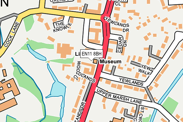
EN11 8BH is located in the Broxbourne and Hoddesdon South electoral ward, within the local authority district of Broxbourne and the English Parliamentary constituency of Broxbourne. The Sub Integrated Care Board (ICB) Location is NHS Hertfordshire and West Essex ICB - 06K and the police force is Hertfordshire. This postcode has been in use since January 1980.


GetTheData
Source: OS OpenMap – Local (Ordnance Survey)
Source: OS VectorMap District (Ordnance Survey)
Licence: Open Government Licence (requires attribution)
| Easting | 537191 |
| Northing | 208145 |
| Latitude | 51.755200 |
| Longitude | -0.013794 |
GetTheData
Source: Open Postcode Geo
Licence: Open Government Licence
| Country | England |
| Postcode District | EN11 |
| ➜ EN11 open data dashboard ➜ See where EN11 is on a map ➜ Where is Hoddesdon? | |
GetTheData
Source: Land Registry Price Paid Data
Licence: Open Government Licence
Elevation or altitude of EN11 8BH as distance above sea level:
| Metres | Feet | |
|---|---|---|
| Elevation | 40m | 131ft |
Elevation is measured from the approximate centre of the postcode, to the nearest point on an OS contour line from OS Terrain 50, which has contour spacing of ten vertical metres.
➜ How high above sea level am I? Find the elevation of your current position using your device's GPS.
GetTheData
Source: Open Postcode Elevation
Licence: Open Government Licence
| Ward | Broxbourne And Hoddesdon South |
| Constituency | Broxbourne |
GetTheData
Source: ONS Postcode Database
Licence: Open Government Licence
| August 2023 | Violence and sexual offences | On or near The Knowle | 166m |
| August 2023 | Violence and sexual offences | On or near The Knowle | 166m |
| July 2023 | Violence and sexual offences | On or near The Knowle | 166m |
| ➜ Get more crime data in our Crime section | |||
GetTheData
Source: data.police.uk
Licence: Open Government Licence
| Broxbourne Civic Hall (High Street) | Hoddesdon | 25m |
| Broxbourne Civic Hall (High Street) | Hoddesdon | 41m |
| Priory Close (High Street) | Hoddesdon | 298m |
| Brocket Road (High Street) | Hoddesdon | 420m |
| St David's Drive (High Road) | Spitalbrook | 440m |
| Broxbourne Station | 0.9km |
| Rye House Station | 2.1km |
| St Margarets (Herts) Station | 3.8km |
GetTheData
Source: NaPTAN
Licence: Open Government Licence
GetTheData
Source: ONS Postcode Database
Licence: Open Government Licence


➜ Get more ratings from the Food Standards Agency
GetTheData
Source: Food Standards Agency
Licence: FSA terms & conditions
| Last Collection | |||
|---|---|---|---|
| Location | Mon-Fri | Sat | Distance |
| Police Station | 18:30 | 11:00 | 26m |
| Admirals Walk | 18:15 | 11:00 | 479m |
| Hoddesdon P.o. | 19:00 | 12:00 | 512m |
GetTheData
Source: Dracos
Licence: Creative Commons Attribution-ShareAlike
| Facility | Distance |
|---|---|
| Hoddesdon Open Air Pool (Closed) High Street, Hoddesdon Swimming Pool | 223m |
| Robert Barclay Academy Cock Lane, Hoddesdon Grass Pitches, Health and Fitness Gym, Sports Hall, Swimming Pool | 297m |
| The Stewart Edwards Stadium Park View, Hoddesdon Grass Pitches, Artificial Grass Pitch | 396m |
GetTheData
Source: Active Places
Licence: Open Government Licence
| School | Phase of Education | Distance |
|---|---|---|
| St Cross Catholic Primary School Upper Marsh Lane, Hoddesdon, EN11 8BN | Primary | 221m |
| Robert Barclay Academy Cock Lane, Hoddesdon, EN11 8JY | Secondary | 297m |
| St Augustine's Catholic Primary School Riversmead, Hoddesdon, EN11 8DP | Primary | 490m |
GetTheData
Source: Edubase
Licence: Open Government Licence
The below table lists the International Territorial Level (ITL) codes (formerly Nomenclature of Territorial Units for Statistics (NUTS) codes) and Local Administrative Units (LAU) codes for EN11 8BH:
| ITL 1 Code | Name |
|---|---|
| TLH | East |
| ITL 2 Code | Name |
| TLH2 | Bedfordshire and Hertfordshire |
| ITL 3 Code | Name |
| TLH23 | Hertfordshire CC |
| LAU 1 Code | Name |
| E07000095 | Broxbourne |
GetTheData
Source: ONS Postcode Directory
Licence: Open Government Licence
The below table lists the Census Output Area (OA), Lower Layer Super Output Area (LSOA), and Middle Layer Super Output Area (MSOA) for EN11 8BH:
| Code | Name | |
|---|---|---|
| OA | E00118494 | |
| LSOA | E01023321 | Broxbourne 003B |
| MSOA | E02004845 | Broxbourne 003 |
GetTheData
Source: ONS Postcode Directory
Licence: Open Government Licence
| EN11 8DT | Yewlands | 53m |
| EN11 8BS | High Street | 64m |
| EN11 8BY | High Street | 66m |
| EN11 8UX | High Street | 68m |
| EN11 8AY | Woodlands Close | 94m |
| EN11 8JZ | Cock Lane | 123m |
| EN11 8BZ | Cedar Green | 136m |
| EN11 8BT | Yewlands | 139m |
| EN11 8BB | Yew Walk | 143m |
| EN11 8BN | Upper Marsh Lane | 147m |
GetTheData
Source: Open Postcode Geo; Land Registry Price Paid Data
Licence: Open Government Licence