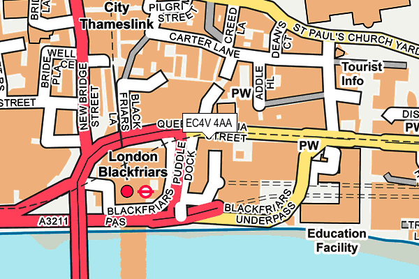
EC4V 4AA is located in the Castle Baynard electoral ward, within the London borough of City of London and the English Parliamentary constituency of Cities of London and Westminster. The Sub Integrated Care Board (ICB) Location is NHS North East London ICB - A3A8R and the police force is City of London. This postcode has been in use since January 1980.


GetTheData
Source: OS OpenMap – Local (Ordnance Survey)
Source: OS VectorMap District (Ordnance Survey)
Licence: Open Government Licence (requires attribution)
| Easting | 531833 |
| Northing | 180938 |
| Latitude | 51.511996 |
| Longitude | -0.101609 |
GetTheData
Source: Open Postcode Geo
Licence: Open Government Licence
| Country | England |
| Postcode District | EC4V |
| ➜ EC4V open data dashboard ➜ See where EC4V is on a map ➜ Where is City of London? | |
GetTheData
Source: Land Registry Price Paid Data
Licence: Open Government Licence
Elevation or altitude of EC4V 4AA as distance above sea level:
| Metres | Feet | |
|---|---|---|
| Elevation | 10m | 33ft |
Elevation is measured from the approximate centre of the postcode, to the nearest point on an OS contour line from OS Terrain 50, which has contour spacing of ten vertical metres.
➜ How high above sea level am I? Find the elevation of your current position using your device's GPS.
GetTheData
Source: Open Postcode Elevation
Licence: Open Government Licence
| Ward | Castle Baynard |
| Constituency | Cities Of London And Westminster |
GetTheData
Source: ONS Postcode Database
Licence: Open Government Licence
| June 2022 | Theft from the person | On or near Queen Victoria Street | 57m |
| June 2022 | Theft from the person | On or near Queen Victoria Street | 57m |
| June 2022 | Anti-social behaviour | On or near St Andrew'S Hill | 74m |
| ➜ Get more crime data in our Crime section | |||
GetTheData
Source: data.police.uk
Licence: Open Government Licence
| Blackfriars | Blackfriars | 69m |
| Blackfriars | Blackfriars | 83m |
| Blackfriars | Blackfriars | 89m |
| Millennium Bridge (Queen Victoria Street) | City Of London | 140m |
| Blackfriars Station North Entrance | Blackfriars | 192m |
| Blackfriars Underground Station | Blackfriars | 150m |
| St. Paul's Underground Station | St Pauls | 431m |
| Mansion House Underground Station | Mansion House | 528m |
| Cannon Street Underground Station | Cannon Street | 778m |
| Temple Underground Station | Temple | 885m |
| London Blackfriars Station | 0.1km |
| City Thameslink Station | 0.3km |
| London Cannon Street Station | 0.8km |
GetTheData
Source: NaPTAN
Licence: Open Government Licence
GetTheData
Source: ONS Postcode Database
Licence: Open Government Licence


➜ Get more ratings from the Food Standards Agency
GetTheData
Source: Food Standards Agency
Licence: FSA terms & conditions
| Last Collection | |||
|---|---|---|---|
| Location | Mon-Fri | Sat | Distance |
| Queen Victoria Street (Godliman St) (R) | 18:30 | 12:00 | 185m |
| Queen Victoria Street | 18:30 | 12:00 | 185m |
| St Pauls Churchyard | 18:30 | 12:00 | 208m |
GetTheData
Source: Dracos
Licence: Creative Commons Attribution-ShareAlike
| Facility | Distance |
|---|---|
| Anytime Fitness (London St Pauls) Priory Court, London Health and Fitness Gym, Studio | 188m |
| City Of London School Queen Victoria Street, London Health and Fitness Gym, Sports Hall, Swimming Pool, Squash Courts, Artificial Grass Pitch | 188m |
| St Pauls Health & Fitness Club Godliman Street, London Health and Fitness Gym, Swimming Pool, Studio | 195m |
GetTheData
Source: Active Places
Licence: Open Government Licence
| School | Phase of Education | Distance |
|---|---|---|
| City of London School 107 Queen Victoria Street, London, EC4V 3AL | Not applicable | 175m |
| St Paul's Cathedral School 2 New Change, London, EC4M 9AD | Not applicable | 390m |
| London Nautical School 61 Stamford Street, Waterloo, London, SE1 9NA | Secondary | 772m |
GetTheData
Source: Edubase
Licence: Open Government Licence
The below table lists the International Territorial Level (ITL) codes (formerly Nomenclature of Territorial Units for Statistics (NUTS) codes) and Local Administrative Units (LAU) codes for EC4V 4AA:
| ITL 1 Code | Name |
|---|---|
| TLI | London |
| ITL 2 Code | Name |
| TLI3 | Inner London - West |
| ITL 3 Code | Name |
| TLI31 | Camden and City of London |
| LAU 1 Code | Name |
| E09000001 | City of London |
GetTheData
Source: ONS Postcode Directory
Licence: Open Government Licence
The below table lists the Census Output Area (OA), Lower Layer Super Output Area (LSOA), and Middle Layer Super Output Area (MSOA) for EC4V 4AA:
| Code | Name | |
|---|---|---|
| OA | E00000024 | |
| LSOA | E01032739 | City of London 001F |
| MSOA | E02000001 | City of London 001 |
GetTheData
Source: ONS Postcode Directory
Licence: Open Government Licence
| EC4V 5DE | St Andrews Hill | 58m |
| EC4V 5DT | Friar Street | 96m |
| EC4V 5EH | Ireland Yard | 101m |
| EC4V 5AH | Wardrobe Place | 105m |
| EC4V 5DR | Burgon Street | 107m |
| EC4V 5BY | St Andrews Hill | 108m |
| EC4V 5EQ | Carter Lane | 135m |
| EC4V 5EA | Carter Lane | 144m |
| EC4V 5EN | Carter Court | 155m |
| EC4V 5EP | Carter Lane | 156m |
GetTheData
Source: Open Postcode Geo; Land Registry Price Paid Data
Licence: Open Government Licence