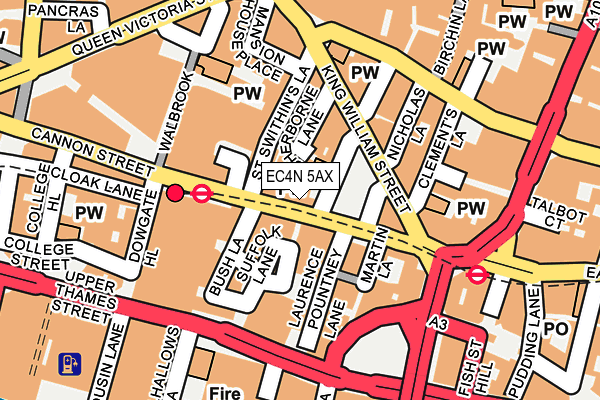
EC4N 5AX lies on Cannon Street in London. EC4N 5AX is located in the Candlewick electoral ward, within the London borough of City of London and the English Parliamentary constituency of Cities of London and Westminster. The Sub Integrated Care Board (ICB) Location is NHS North East London ICB - A3A8R and the police force is City of London. This postcode has been in use since January 1980.


GetTheData
Source: OS OpenMap – Local (Ordnance Survey)
Source: OS VectorMap District (Ordnance Survey)
Licence: Open Government Licence (requires attribution)
| Easting | 532730 |
| Northing | 180897 |
| Latitude | 51.511419 |
| Longitude | -0.088680 |
GetTheData
Source: Open Postcode Geo
Licence: Open Government Licence
| Street | Cannon Street |
| Town/City | London |
| Country | England |
| Postcode District | EC4N |
➜ See where EC4N is on a map ➜ Where is City of London? | |
GetTheData
Source: Land Registry Price Paid Data
Licence: Open Government Licence
Elevation or altitude of EC4N 5AX as distance above sea level:
| Metres | Feet | |
|---|---|---|
| Elevation | 10m | 33ft |
Elevation is measured from the approximate centre of the postcode, to the nearest point on an OS contour line from OS Terrain 50, which has contour spacing of ten vertical metres.
➜ How high above sea level am I? Find the elevation of your current position using your device's GPS.
GetTheData
Source: Open Postcode Elevation
Licence: Open Government Licence
| Ward | Candlewick |
| Constituency | Cities Of London And Westminster |
GetTheData
Source: ONS Postcode Database
Licence: Open Government Licence
| Cannon Street | Cannon Street | 29m |
| Cannon Street | Cannon Street | 34m |
| Bank Station King William St | City Of London | 104m |
| King William St Monument Stn (King William Street) | City Of London | 104m |
| Cannon Street | Cannon Street | 152m |
| Cannon Street Underground Station | Cannon Street | 120m |
| Bank Dlr Station (Cornhill) | Bank | 202m |
| Monument Underground Station | Monument | 206m |
| Bank Underground Station | Bank | 223m |
| Mansion House Underground Station | Mansion House | 376m |
| London Cannon Street Station | 0.1km |
| London Fenchurch Street Station | 0.7km |
| London Bridge Station | 0.7km |
GetTheData
Source: NaPTAN
Licence: Open Government Licence
GetTheData
Source: ONS Postcode Database
Licence: Open Government Licence


➜ Get more ratings from the Food Standards Agency
GetTheData
Source: Food Standards Agency
Licence: FSA terms & conditions
| Last Collection | |||
|---|---|---|---|
| Location | Mon-Fri | Sat | Distance |
| Lombard St (King William St) | 18:30 | 12:00 | 175m |
| Lombard St (King William St) | 178m | ||
| Monument Station (Eastcheap) | 18:30 | 12:00 | 209m |
GetTheData
Source: Dracos
Licence: Creative Commons Attribution-ShareAlike
The below table lists the International Territorial Level (ITL) codes (formerly Nomenclature of Territorial Units for Statistics (NUTS) codes) and Local Administrative Units (LAU) codes for EC4N 5AX:
| ITL 1 Code | Name |
|---|---|
| TLI | London |
| ITL 2 Code | Name |
| TLI3 | Inner London - West |
| ITL 3 Code | Name |
| TLI31 | Camden and City of London |
| LAU 1 Code | Name |
| E09000001 | City of London |
GetTheData
Source: ONS Postcode Directory
Licence: Open Government Licence
The below table lists the Census Output Area (OA), Lower Layer Super Output Area (LSOA), and Middle Layer Super Output Area (MSOA) for EC4N 5AX:
| Code | Name | |
|---|---|---|
| OA | E00166755 | |
| LSOA | E01032739 | City of London 001F |
| MSOA | E02000001 | City of London 001 |
GetTheData
Source: ONS Postcode Directory
Licence: Open Government Licence
| EC4N 5AT | Cannon Street | 10m |
| EC4N 7BA | Abchurch Yard | 14m |
| EC4R 0AW | Bush Lane | 46m |
| EC4N 8AD | St Swithins Lane | 47m |
| EC4N 6EU | Cannon Street | 51m |
| EC4N 8AL | St Swithins Lane | 61m |
| EC4R 0EE | Laurence Pountney Lane | 62m |
| EC4N 5AD | Cannon Street | 71m |
| EC4R 0EH | Laurence Pountney Hill | 78m |
| EC4N 5AG | Cannon Street | 90m |
GetTheData
Source: Open Postcode Geo; Land Registry Price Paid Data
Licence: Open Government Licence