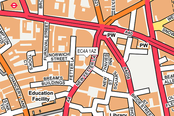
EC4A 1AZ is located in the Castle Baynard electoral ward, within the London borough of City of London and the English Parliamentary constituency of Cities of London and Westminster. The Sub Integrated Care Board (ICB) Location is NHS North East London ICB - A3A8R and the police force is City of London. This postcode has been in use since March 2014.


GetTheData
Source: OS OpenMap – Local (Ordnance Survey)
Source: OS VectorMap District (Ordnance Survey)
Licence: Open Government Licence (requires attribution)
| Easting | 531348 |
| Northing | 181460 |
| Latitude | 51.516800 |
| Longitude | -0.108400 |
GetTheData
Source: Open Postcode Geo
Licence: Open Government Licence
| Country | England |
| Postcode District | EC4A |
| ➜ EC4A open data dashboard ➜ See where EC4A is on a map ➜ Where is City of London? | |
GetTheData
Source: Land Registry Price Paid Data
Licence: Open Government Licence
Elevation or altitude of EC4A 1AZ as distance above sea level:
| Metres | Feet | |
|---|---|---|
| Elevation | 20m | 66ft |
Elevation is measured from the approximate centre of the postcode, to the nearest point on an OS contour line from OS Terrain 50, which has contour spacing of ten vertical metres.
➜ How high above sea level am I? Find the elevation of your current position using your device's GPS.
GetTheData
Source: Open Postcode Elevation
Licence: Open Government Licence
| Ward | Castle Baynard |
| Constituency | Cities Of London And Westminster |
GetTheData
Source: ONS Postcode Database
Licence: Open Government Licence
| November 2023 | Other theft | On or near Saffron Hill | 418m |
| October 2022 | Other theft | On or near Saffron Hill | 418m |
| June 2022 | Theft from the person | On or near New Fetter Lane | 30m |
| ➜ Get more crime data in our Crime section | |||
GetTheData
Source: data.police.uk
Licence: Open Government Licence
| New Fetter Lane | City Of London | 57m |
| New Fetter Lane | City Of London | 62m |
| Holborn Circus Fetter Lane (Holborn) | Holborn | 110m |
| Holborn Circus Fetter Lane | Holborn | 127m |
| Holborn Circus Fetter Lane (Holborn) | Holborn | 142m |
| Chancery Lane Underground Station | Chancery Lane | 273m |
| Farringdon Underground Station | Farringdon | 454m |
| Blackfriars Underground Station | Blackfriars | 667m |
| Temple Underground Station | Temple | 762m |
| St. Paul's Underground Station | St Pauls | 780m |
| Farringdon (London) Station | 0.4km |
| City Thameslink Station | 0.5km |
| London Blackfriars Station | 0.7km |
GetTheData
Source: NaPTAN
Licence: Open Government Licence
GetTheData
Source: ONS Postcode Database
Licence: Open Government Licence


➜ Get more ratings from the Food Standards Agency
GetTheData
Source: Food Standards Agency
Licence: FSA terms & conditions
| Last Collection | |||
|---|---|---|---|
| Location | Mon-Fri | Sat | Distance |
| New Fetter Lane (O/S 10) | 18:30 | 12:00 | 30m |
| Hatton Garden (Holborn Circus) | 18:30 | 183m | |
| Holborn (Furnival Street) | 18:30 | 12:00 | 189m |
GetTheData
Source: Dracos
Licence: Creative Commons Attribution-ShareAlike
| Facility | Distance |
|---|---|
| The Gym Group (London Holborn Circus) New Fetter Lane, London Health and Fitness Gym, Studio | 41m |
| Fitness First (Fetter Lane) (Closed) Fetter Lane, London Health and Fitness Gym, Studio | 227m |
| Gymbox (Farringdon) Leather Lane, London Studio, Health and Fitness Gym | 240m |
GetTheData
Source: Active Places
Licence: Open Government Licence
| School | Phase of Education | Distance |
|---|---|---|
| City Junior School CITY JUNIOR SCHOOL, 4 GRAY'S INN PLACE, LONDON, WC1R 5EY | Not applicable | 416m |
| St Alban's Church of England Primary School Baldwins Gardens, Holborn, London, EC1N 7SD | Primary | 420m |
| University of the Arts London 272 High Holborn, London, WC1V 7EY | Not applicable | 569m |
GetTheData
Source: Edubase
Licence: Open Government Licence
The below table lists the International Territorial Level (ITL) codes (formerly Nomenclature of Territorial Units for Statistics (NUTS) codes) and Local Administrative Units (LAU) codes for EC4A 1AZ:
| ITL 1 Code | Name |
|---|---|
| TLI | London |
| ITL 2 Code | Name |
| TLI3 | Inner London - West |
| ITL 3 Code | Name |
| TLI31 | Camden and City of London |
| LAU 1 Code | Name |
| E09000001 | City of London |
GetTheData
Source: ONS Postcode Directory
Licence: Open Government Licence
The below table lists the Census Output Area (OA), Lower Layer Super Output Area (LSOA), and Middle Layer Super Output Area (MSOA) for EC4A 1AZ:
| Code | Name | |
|---|---|---|
| OA | E00000026 | |
| LSOA | E01032740 | City of London 001G |
| MSOA | E02000001 | City of London 001 |
GetTheData
Source: ONS Postcode Directory
Licence: Open Government Licence
| EC4A 1EP | Fetter Lane | 66m |
| EC1N 2HA | Holborn Circus | 68m |
| EC4A 1EQ | Fetter Lane | 82m |
| EC4A 3BF | New Street Square | 99m |
| EC4A 3AG | St Andrew Street | 99m |
| EC4A 1ES | Fetter Lane | 117m |
| EC4A 3BE | Shoe Lane | 124m |
| EC4A 1GP | Greystoke Place | 126m |
| EC1N 2JT | Dyers Buildings | 131m |
| EC4A 1JQ | Furnival Street | 145m |
GetTheData
Source: Open Postcode Geo; Land Registry Price Paid Data
Licence: Open Government Licence