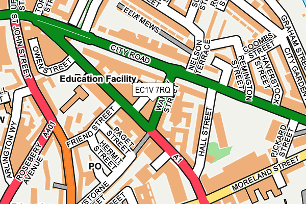
EC1V 7RQ is located in the St Peter's & Canalside electoral ward, within the London borough of Islington and the English Parliamentary constituency of Islington South and Finsbury. The Sub Integrated Care Board (ICB) Location is NHS North Central London ICB - 93C and the police force is Metropolitan Police. This postcode has been in use since December 1998.


GetTheData
Source: OS OpenMap – Local (Ordnance Survey)
Source: OS VectorMap District (Ordnance Survey)
Licence: Open Government Licence (requires attribution)
| Easting | 531725 |
| Northing | 182970 |
| Latitude | 51.530282 |
| Longitude | -0.102406 |
GetTheData
Source: Open Postcode Geo
Licence: Open Government Licence
| Country | England |
| Postcode District | EC1V |
| ➜ EC1V open data dashboard ➜ See where EC1V is on a map ➜ Where is London? | |
GetTheData
Source: Land Registry Price Paid Data
Licence: Open Government Licence
Elevation or altitude of EC1V 7RQ as distance above sea level:
| Metres | Feet | |
|---|---|---|
| Elevation | 30m | 98ft |
Elevation is measured from the approximate centre of the postcode, to the nearest point on an OS contour line from OS Terrain 50, which has contour spacing of ten vertical metres.
➜ How high above sea level am I? Find the elevation of your current position using your device's GPS.
GetTheData
Source: Open Postcode Elevation
Licence: Open Government Licence
| Ward | St Peter's & Canalside |
| Constituency | Islington South And Finsbury |
GetTheData
Source: ONS Postcode Database
Licence: Open Government Licence
| January 2024 | Other theft | On or near Owen'S Row | 183m |
| January 2024 | Other theft | On or near Owen'S Row | 183m |
| January 2024 | Theft from the person | On or near Owen'S Row | 183m |
| ➜ Get more crime data in our Crime section | |||
GetTheData
Source: data.police.uk
Licence: Open Government Licence
| Hall Street (Goswell Road) | Finsbury | 121m |
| Rosebery Avenue Sadlers Wells | Finsbury | 198m |
| Angel Islington | Angel | 207m |
| Central Street (City Road) | Angel | 211m |
| Friend Street Sadlers Wells | Finsbury | 214m |
| Angel Underground Station | Angel | 356m |
| Old Street Underground Station | Old Street | 1,128m |
| Farringdon Underground Station | Farringdon | 1,129m |
| Barbican Underground Station | Barbican | 1,155m |
| King's Cross St. Pancras Underground Station | King's Cross | 1,443m |
| Old Street Station | 1.1km |
| Farringdon (London) Station | 1.1km |
| Essex Road Station | 1.2km |
GetTheData
Source: NaPTAN
Licence: Open Government Licence
GetTheData
Source: ONS Postcode Database
Licence: Open Government Licence


➜ Get more ratings from the Food Standards Agency
GetTheData
Source: Food Standards Agency
Licence: FSA terms & conditions
| Last Collection | |||
|---|---|---|---|
| Location | Mon-Fri | Sat | Distance |
| City Road (Hall St) | 18:30 | 109m | |
| City Road (Hall St) | 18:30 | 12:00 | 110m |
| Elia Street/Nelson Terrace | 18:30 | 12:00 | 158m |
GetTheData
Source: Dracos
Licence: Creative Commons Attribution-ShareAlike
| Facility | Distance |
|---|---|
| The Gym Group (London Angel) Goswell Road, London Health and Fitness Gym | 59m |
| Fitness First (Angel) City Road, London Health and Fitness Gym, Studio | 143m |
| City And Islington College (Centre Of Applied Sciences) Goswell Road, London Health and Fitness Gym, Sports Hall, Artificial Grass Pitch | 158m |
GetTheData
Source: Active Places
Licence: Open Government Licence
| School | Phase of Education | Distance |
|---|---|---|
| City University Northampton Square, London, EC1V 0HB | Not applicable | 277m |
| Moreland Primary School Moreland Street, London, EC1V 8BB | Primary | 298m |
| The ArtsXchange City Road, London, EC1V 1JX | Not applicable | 325m |
GetTheData
Source: Edubase
Licence: Open Government Licence
The below table lists the International Territorial Level (ITL) codes (formerly Nomenclature of Territorial Units for Statistics (NUTS) codes) and Local Administrative Units (LAU) codes for EC1V 7RQ:
| ITL 1 Code | Name |
|---|---|
| TLI | London |
| ITL 2 Code | Name |
| TLI4 | Inner London - East |
| ITL 3 Code | Name |
| TLI43 | Haringey and Islington |
| LAU 1 Code | Name |
| E09000019 | Islington |
GetTheData
Source: ONS Postcode Directory
Licence: Open Government Licence
The below table lists the Census Output Area (OA), Lower Layer Super Output Area (LSOA), and Middle Layer Super Output Area (MSOA) for EC1V 7RQ:
| Code | Name | |
|---|---|---|
| OA | E00174761 | |
| LSOA | E01002707 | Islington 022B |
| MSOA | E02000575 | Islington 022 |
GetTheData
Source: ONS Postcode Directory
Licence: Open Government Licence
| EC1V 7LT | Wakley Street | 25m |
| EC1V 7LN | Fredericks Row | 26m |
| EC1V 7LP | Sidney Grove | 39m |
| EC1V 2PY | City Road | 50m |
| EC1V 7AH | Goswell Road | 59m |
| EC1V 2PZ | City Road | 61m |
| EC1V 7LQ | Goswell Road | 84m |
| EC1V 2PT | Angel Gate | 86m |
| EC1V 7JD | Goswell Road | 88m |
| EC1V 7PA | Paget Street | 95m |
GetTheData
Source: Open Postcode Geo; Land Registry Price Paid Data
Licence: Open Government Licence