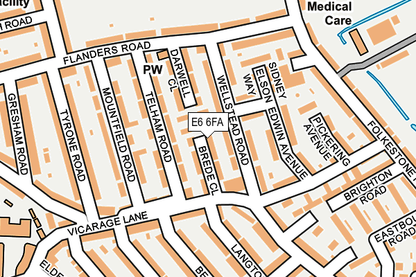
E6 6FA is located in the East Ham South electoral ward, within the London borough of Newham and the English Parliamentary constituency of East Ham. The Sub Integrated Care Board (ICB) Location is NHS North East London ICB - A3A8R and the police force is Metropolitan Police. This postcode has been in use since October 2016.


GetTheData
Source: OS OpenMap – Local (Ordnance Survey)
Source: OS VectorMap District (Ordnance Survey)
Licence: Open Government Licence (requires attribution)
| Easting | 543161 |
| Northing | 182987 |
| Latitude | 51.527654 |
| Longitude | 0.062383 |
GetTheData
Source: Open Postcode Geo
Licence: Open Government Licence
| Country | England |
| Postcode District | E6 |
➜ See where E6 is on a map ➜ Where is East Ham? | |
GetTheData
Source: Land Registry Price Paid Data
Licence: Open Government Licence
Elevation or altitude of E6 6FA as distance above sea level:
| Metres | Feet | |
|---|---|---|
| Elevation | 10m | 33ft |
Elevation is measured from the approximate centre of the postcode, to the nearest point on an OS contour line from OS Terrain 50, which has contour spacing of ten vertical metres.
➜ How high above sea level am I? Find the elevation of your current position using your device's GPS.
GetTheData
Source: Open Postcode Elevation
Licence: Open Government Licence
| Ward | East Ham South |
| Constituency | East Ham |
GetTheData
Source: ONS Postcode Database
Licence: Open Government Licence
| Becket Avenue | Wallend | 115m |
| Charlemont Road | Wallend | 151m |
| Becket Avenue | Wallend | 154m |
| Charlemont Road | Wallend | 192m |
| Flanders Road | Wallend | 193m |
| East Ham Underground Station | East Ham | 1,476m |
| Beckton Dlr Station (Woolwich Manor Road) | Beckton | 1,480m |
| Barking Underground Station | Barking | 1,835m |
| Barking Station | 1.8km |
| Woodgrange Park Station | 2.7km |
| Manor Park Station | 3km |
GetTheData
Source: NaPTAN
Licence: Open Government Licence
| Percentage of properties with Next Generation Access | 100.0% |
| Percentage of properties with Superfast Broadband | 100.0% |
| Percentage of properties with Ultrafast Broadband | 100.0% |
| Percentage of properties with Full Fibre Broadband | 0.0% |
Superfast Broadband is between 30Mbps and 300Mbps
Ultrafast Broadband is > 300Mbps
| Median download speed | 79.7Mbps |
| Average download speed | 93.2Mbps |
| Maximum download speed | 200.00Mbps |
| Median upload speed | 19.2Mbps |
| Average upload speed | 14.8Mbps |
| Maximum upload speed | 20.00Mbps |
| Percentage of properties unable to receive 2Mbps | 0.0% |
| Percentage of properties unable to receive 5Mbps | 0.0% |
| Percentage of properties unable to receive 10Mbps | 0.0% |
| Percentage of properties unable to receive 30Mbps | 0.0% |
GetTheData
Source: Ofcom
Licence: Ofcom Terms of Use (requires attribution)
GetTheData
Source: ONS Postcode Database
Licence: Open Government Licence


➜ Get more ratings from the Food Standards Agency
GetTheData
Source: Food Standards Agency
Licence: FSA terms & conditions
| Last Collection | |||
|---|---|---|---|
| Location | Mon-Fri | Sat | Distance |
| Brede Close | 17:30 | 11:30 | 81m |
| Charlemont Road | 18:30 | 11:30 | 288m |
| Blaney Crescent | 17:30 | 11:30 | 385m |
GetTheData
Source: Dracos
Licence: Creative Commons Attribution-ShareAlike
| Risk of E6 6FA flooding from rivers and sea | Low |
| ➜ E6 6FA flood map | |
GetTheData
Source: Open Flood Risk by Postcode
Licence: Open Government Licence
The below table lists the International Territorial Level (ITL) codes (formerly Nomenclature of Territorial Units for Statistics (NUTS) codes) and Local Administrative Units (LAU) codes for E6 6FA:
| ITL 1 Code | Name |
|---|---|
| TLI | London |
| ITL 2 Code | Name |
| TLI4 | Inner London - East |
| ITL 3 Code | Name |
| TLI41 | Hackney and Newham |
| LAU 1 Code | Name |
| E09000025 | Newham |
GetTheData
Source: ONS Postcode Directory
Licence: Open Government Licence
The below table lists the Census Output Area (OA), Lower Layer Super Output Area (LSOA), and Middle Layer Super Output Area (MSOA) for E6 6FA:
| Code | Name | |
|---|---|---|
| OA | E00017862 | |
| LSOA | E01003535 | Newham 023A |
| MSOA | E02000736 | Newham 023 |
GetTheData
Source: ONS Postcode Directory
Licence: Open Government Licence
| E6 6DF | Brede Close | 28m |
| E6 6DE | Wellstead Road | 38m |
| E6 6BS | Telham Road | 58m |
| E6 6DD | Wellstead Road | 60m |
| E6 6BP | Telham Road | 84m |
| E6 6DA | Edwin Avenue | 88m |
| E6 6BW | Telham Road | 104m |
| E6 6BT | Darwell Close | 109m |
| E6 6BJ | Mountfield Road | 113m |
| E6 6DB | Edwin Avenue | 116m |
GetTheData
Source: Open Postcode Geo; Land Registry Price Paid Data
Licence: Open Government Licence