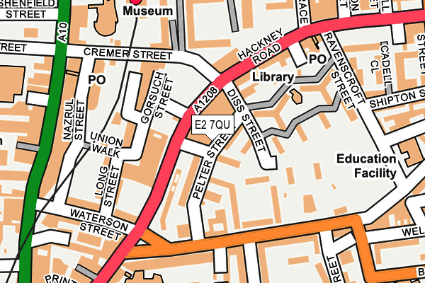
E2 7QU is located in the Weavers electoral ward, within the London borough of Tower Hamlets and the English Parliamentary constituency of Bethnal Green and Bow. The Sub Integrated Care Board (ICB) Location is NHS North East London ICB - A3A8R and the police force is Metropolitan Police. This postcode has been in use since January 1980.


GetTheData
Source: OS OpenMap – Local (Ordnance Survey)
Source: OS VectorMap District (Ordnance Survey)
Licence: Open Government Licence (requires attribution)
| Easting | 533687 |
| Northing | 182932 |
| Latitude | 51.529480 |
| Longitude | -0.074152 |
GetTheData
Source: Open Postcode Geo
Licence: Open Government Licence
| Country | England |
| Postcode District | E2 |
| ➜ E2 open data dashboard ➜ See where E2 is on a map ➜ Where is Bethnal Green? | |
GetTheData
Source: Land Registry Price Paid Data
Licence: Open Government Licence
Elevation or altitude of E2 7QU as distance above sea level:
| Metres | Feet | |
|---|---|---|
| Elevation | 20m | 66ft |
Elevation is measured from the approximate centre of the postcode, to the nearest point on an OS contour line from OS Terrain 50, which has contour spacing of ten vertical metres.
➜ How high above sea level am I? Find the elevation of your current position using your device's GPS.
GetTheData
Source: Open Postcode Elevation
Licence: Open Government Licence
| Ward | Weavers |
| Constituency | Bethnal Green And Bow |
GetTheData
Source: ONS Postcode Database
Licence: Open Government Licence
| January 2024 | Anti-social behaviour | On or near Gascoigne Place | 197m |
| January 2024 | Other theft | On or near Gascoigne Place | 197m |
| January 2024 | Theft from the person | On or near Gascoigne Place | 197m |
| ➜ Get more crime data in our Crime section | |||
GetTheData
Source: data.police.uk
Licence: Open Government Licence
| Hoxton Station | Hoxton | 66m |
| Hoxton Station | Hoxton | 70m |
| Falkirk Street | Hoxton | 227m |
| Hoxton Station Geffrye Museum (Kingsland Road) | Hoxton | 239m |
| Hackney Road Columbia Road | Shoreditch | 242m |
| Old Street Underground Station | Old Street | 1,027m |
| Bethnal Green Underground Station | Bethnal Green | 1,318m |
| Whitechapel Underground Station | Whitechapel | 1,482m |
| Liverpool Street Underground Station | Liverpool Street | 1,486m |
| Moorgate Underground Station | Moorgate | 1,596m |
| Hoxton Station | 0.2km |
| Shoreditch High Street Station | 0.7km |
| Haggerston Station | 1km |
GetTheData
Source: NaPTAN
Licence: Open Government Licence
GetTheData
Source: ONS Postcode Database
Licence: Open Government Licence


➜ Get more ratings from the Food Standards Agency
GetTheData
Source: Food Standards Agency
Licence: FSA terms & conditions
| Last Collection | |||
|---|---|---|---|
| Location | Mon-Fri | Sat | Distance |
| 198 Hackney Road E2 | 18:30 | 12:00 | 201m |
| 120 Kingsland Road | 17:00 | 11:30 | 229m |
| Columbia Road | 17:00 | 11:30 | 238m |
GetTheData
Source: Dracos
Licence: Creative Commons Attribution-ShareAlike
| Facility | Distance |
|---|---|
| Puregym (London Hoxton) Cremer Street, London Health and Fitness Gym | 89m |
| The Tab Centre Godfrey Place, London Sports Hall | 262m |
| Haggerston School Weymouth Terrace, London Sports Hall, Artificial Grass Pitch | 372m |
GetTheData
Source: Active Places
Licence: Open Government Licence
| School | Phase of Education | Distance |
|---|---|---|
| Columbia Market Nursery School Columbia Road, Bethnal Green, London, E2 7PG | Nursery | 121m |
| Columbia Primary School Columbia Road, Bethnal Green, London, E2 7RG | Primary | 286m |
| Virginia Primary School Virginia Road, Bethnal Green, London, E2 7NQ | Primary | 347m |
GetTheData
Source: Edubase
Licence: Open Government Licence
The below table lists the International Territorial Level (ITL) codes (formerly Nomenclature of Territorial Units for Statistics (NUTS) codes) and Local Administrative Units (LAU) codes for E2 7QU:
| ITL 1 Code | Name |
|---|---|
| TLI | London |
| ITL 2 Code | Name |
| TLI4 | Inner London - East |
| ITL 3 Code | Name |
| TLI42 | Tower Hamlets |
| LAU 1 Code | Name |
| E09000030 | Tower Hamlets |
GetTheData
Source: ONS Postcode Directory
Licence: Open Government Licence
The below table lists the Census Output Area (OA), Lower Layer Super Output Area (LSOA), and Middle Layer Super Output Area (MSOA) for E2 7QU:
| Code | Name | |
|---|---|---|
| OA | E00021697 | |
| LSOA | E01004318 | Tower Hamlets 006D |
| MSOA | E02000869 | Tower Hamlets 006 |
GetTheData
Source: ONS Postcode Directory
Licence: Open Government Licence
| E2 7RA | Vaughan Estate | 30m |
| E2 7PF | Pelter Street | 34m |
| E2 7PE | Pelter Street | 62m |
| E2 7PW | Baroness Road | 75m |
| E2 8FE | Hackney Road | 78m |
| E2 7QX | Diss Street | 78m |
| E2 8FD | Hackney Road | 82m |
| E2 8ET | Hackney Road | 86m |
| E2 7QY | Diss Street | 97m |
| E2 7QZ | Diss Street | 97m |
GetTheData
Source: Open Postcode Geo; Land Registry Price Paid Data
Licence: Open Government Licence