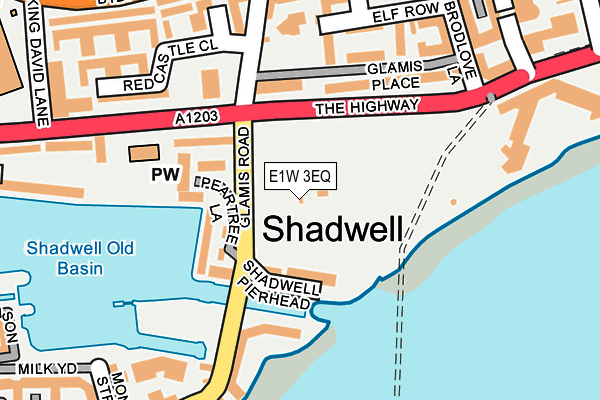
E1W 3EQ is located in the St Katharine's & Wapping electoral ward, within the London borough of Tower Hamlets and the English Parliamentary constituency of Poplar and Limehouse. The Sub Integrated Care Board (ICB) Location is NHS North East London ICB - A3A8R and the police force is Metropolitan Police. This postcode has been in use since January 2005.


GetTheData
Source: OS OpenMap – Local (Ordnance Survey)
Source: OS VectorMap District (Ordnance Survey)
Licence: Open Government Licence (requires attribution)
| Easting | 535435 |
| Northing | 180695 |
| Latitude | 51.508961 |
| Longitude | -0.049828 |
GetTheData
Source: Open Postcode Geo
Licence: Open Government Licence
| Country | England |
| Postcode District | E1W |
➜ See where E1W is on a map ➜ Where is London? | |
GetTheData
Source: Land Registry Price Paid Data
Licence: Open Government Licence
Elevation or altitude of E1W 3EQ as distance above sea level:
| Metres | Feet | |
|---|---|---|
| Elevation | 10m | 33ft |
Elevation is measured from the approximate centre of the postcode, to the nearest point on an OS contour line from OS Terrain 50, which has contour spacing of ten vertical metres.
➜ How high above sea level am I? Find the elevation of your current position using your device's GPS.
GetTheData
Source: Open Postcode Elevation
Licence: Open Government Licence
| Ward | St Katharine's & Wapping |
| Constituency | Poplar And Limehouse |
GetTheData
Source: ONS Postcode Database
Licence: Open Government Licence
| King Edward Memorial Park (Glamis Road) | Shadwell | 52m |
| King Edward Memorial Park (Glamis Road) | Shadwell | 71m |
| Glamis Place (Glamis Road) | Shadwell | 147m |
| Shadwell Basin | Shadwell | 154m |
| Shadwell Basin | Shadwell | 159m |
| Shadwell Dlr Station (Martha Street) | Shadwell | 562m |
| Limehouse Dlr Station (Commercial Road) | Limehouse | 793m |
| Canada Water Underground Station | Canada Water | 1,226m |
| Whitechapel Underground Station | Whitechapel | 1,369m |
| Stepney Green Underground Station | Stepney Green | 1,452m |
| Shadwell Station | 0.6km |
| Wapping Station | 0.7km |
| Limehouse Station | 0.8km |
GetTheData
Source: NaPTAN
Licence: Open Government Licence
GetTheData
Source: ONS Postcode Database
Licence: Open Government Licence


➜ Get more ratings from the Food Standards Agency
GetTheData
Source: Food Standards Agency
Licence: FSA terms & conditions
| Last Collection | |||
|---|---|---|---|
| Location | Mon-Fri | Sat | Distance |
| Glamis Road | 18:30 | 11:30 | 235m |
| Glamis Road | 18:30 | 11:30 | 235m |
| The Highway | 17:00 | 11:30 | 430m |
GetTheData
Source: Dracos
Licence: Creative Commons Attribution-ShareAlike
| Risk of E1W 3EQ flooding from rivers and sea | Very Low |
| ➜ E1W 3EQ flood map | |
GetTheData
Source: Open Flood Risk by Postcode
Licence: Open Government Licence
The below table lists the International Territorial Level (ITL) codes (formerly Nomenclature of Territorial Units for Statistics (NUTS) codes) and Local Administrative Units (LAU) codes for E1W 3EQ:
| ITL 1 Code | Name |
|---|---|
| TLI | London |
| ITL 2 Code | Name |
| TLI4 | Inner London - East |
| ITL 3 Code | Name |
| TLI42 | Tower Hamlets |
| LAU 1 Code | Name |
| E09000030 | Tower Hamlets |
GetTheData
Source: ONS Postcode Directory
Licence: Open Government Licence
The below table lists the Census Output Area (OA), Lower Layer Super Output Area (LSOA), and Middle Layer Super Output Area (MSOA) for E1W 3EQ:
| Code | Name | |
|---|---|---|
| OA | E00021656 | |
| LSOA | E01004303 | Tower Hamlets 025D |
| MSOA | E02000888 | Tower Hamlets 025 |
GetTheData
Source: ONS Postcode Directory
Licence: Open Government Licence
| E1W 3SR | Peartree Lane | 93m |
| E1W 3EF | Glamis Place | 125m |
| E1W 3EB | Glamis Road | 148m |
| E1W 3ED | Glamis Road | 148m |
| E1W 3SG | Wapping Wall | 190m |
| E1W 3EE | Glamis Road | 191m |
| E1W 3TF | Wapping Wall | 194m |
| E1W 3EH | Elf Row | 205m |
| E1W 3DQ | Redcastle Close | 214m |
| E1 0ED | Tarbert Walk | 224m |
GetTheData
Source: Open Postcode Geo; Land Registry Price Paid Data
Licence: Open Government Licence