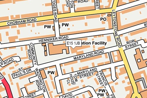
E15 1JB is located in the Maryland electoral ward, within the London borough of Newham and the English Parliamentary constituency of West Ham. The Sub Integrated Care Board (ICB) Location is NHS North East London ICB - A3A8R and the police force is Metropolitan Police. This postcode has been in use since October 2019.


GetTheData
Source: OS OpenMap – Local (Ordnance Survey)
Source: OS VectorMap District (Ordnance Survey)
Licence: Open Government Licence (requires attribution)
| Easting | 538959 |
| Northing | 185177 |
| Latitude | 51.548383 |
| Longitude | 0.002713 |
GetTheData
Source: Open Postcode Geo
Licence: Open Government Licence
| Country | England |
| Postcode District | E15 |
| ➜ E15 open data dashboard ➜ See where E15 is on a map ➜ Where is London? | |
GetTheData
Source: Land Registry Price Paid Data
Licence: Open Government Licence
Elevation or altitude of E15 1JB as distance above sea level:
| Metres | Feet | |
|---|---|---|
| Elevation | 10m | 33ft |
Elevation is measured from the approximate centre of the postcode, to the nearest point on an OS contour line from OS Terrain 50, which has contour spacing of ten vertical metres.
➜ How high above sea level am I? Find the elevation of your current position using your device's GPS.
GetTheData
Source: Open Postcode Elevation
Licence: Open Government Licence
| Ward | Maryland |
| Constituency | West Ham |
GetTheData
Source: ONS Postcode Database
Licence: Open Government Licence
| January 2024 | Violence and sexual offences | On or near Manbey Road | 476m |
| December 2023 | Violence and sexual offences | On or near Whitear Walk | 266m |
| November 2023 | Other crime | On or near Whitear Walk | 266m |
| ➜ Get more crime data in our Crime section | |||
GetTheData
Source: data.police.uk
Licence: Open Government Licence
| Chobham Road (Leytonstone Road) | Stratford New Town | 198m |
| Chobham Road (Leytonstone Road) | Stratford New Town | 247m |
| Maryland (Leytonstone Road) | Stratford | 265m |
| Maryland (Leytonstone Road) | Stratford | 294m |
| Thornham Grove | Stratford New Town | 309m |
| Stratford Dlr Station (Station Street) | Stratford | 845m |
| Stratford Underground Station | Stratford | 847m |
| Stratford International Dlr Station | Stratford | 922m |
| Leyton Underground Station | Leyton | 1,076m |
| Stratford High Street Dlr Station | Stratford | 1,163m |
| Maryland Station | 0.3km |
| Stratford (London) Station | 0.8km |
| Stratford International Station | 0.9km |
GetTheData
Source: NaPTAN
Licence: Open Government Licence
GetTheData
Source: ONS Postcode Database
Licence: Open Government Licence


➜ Get more ratings from the Food Standards Agency
GetTheData
Source: Food Standards Agency
Licence: FSA terms & conditions
| Last Collection | |||
|---|---|---|---|
| Location | Mon-Fri | Sat | Distance |
| Maryland Street | 17:30 | 11:30 | 233m |
| 85 Leytonstone Road | 17:30 | 11:30 | 233m |
| 187 Leytonstone Road E15 | 17:30 | 12:00 | 310m |
GetTheData
Source: Dracos
Licence: Creative Commons Attribution-ShareAlike
| Facility | Distance |
|---|---|
| Anytime Fitness (London Stratford East) Leyton Road, Leyton Road, London Health and Fitness Gym | 410m |
| Sarah Bonnell School Deanery Road, London Sports Hall, Outdoor Tennis Courts | 633m |
| Chobham Academy Cheering Lane, London Artificial Grass Pitch, Studio, Sports Hall, Outdoor Tennis Courts | 682m |
GetTheData
Source: Active Places
Licence: Open Government Licence
| School | Phase of Education | Distance |
|---|---|---|
| Hafs Academy Unit 3, 26 Maryland Road, Stratford, London, E15 1JW | Not applicable | 32m |
| Colegrave Primary School Henniker Road, London, E15 1JY | Primary | 76m |
| Ronald Openshaw Nursery School Henniker Road, Stratford, London, E15 1JP | Nursery | 255m |
GetTheData
Source: Edubase
Licence: Open Government Licence
The below table lists the International Territorial Level (ITL) codes (formerly Nomenclature of Territorial Units for Statistics (NUTS) codes) and Local Administrative Units (LAU) codes for E15 1JB:
| ITL 1 Code | Name |
|---|---|
| TLI | London |
| ITL 2 Code | Name |
| TLI4 | Inner London - East |
| ITL 3 Code | Name |
| TLI41 | Hackney and Newham |
| LAU 1 Code | Name |
| E09000025 | Newham |
GetTheData
Source: ONS Postcode Directory
Licence: Open Government Licence
The below table lists the Census Output Area (OA), Lower Layer Super Output Area (LSOA), and Middle Layer Super Output Area (MSOA) for E15 1JB:
| Code | Name | |
|---|---|---|
| OA | E00018222 | |
| LSOA | E01003616 | Newham 012A |
| MSOA | E02000725 | Newham 012 |
GetTheData
Source: ONS Postcode Directory
Licence: Open Government Licence
| E15 1JW | Maryland Road | 49m |
| E15 1JJ | Maryland Road | 65m |
| E15 1JQ | Falmouth Street | 81m |
| E15 1JY | Henniker Road | 86m |
| E15 1JZ | Henniker Road | 87m |
| E15 1JD | Maryland Street | 117m |
| E15 1JL | Maryland Road | 124m |
| E15 1LU | Chobham Road | 131m |
| E15 1JE | Tom Hood Close | 147m |
| E15 1LG | Leytonstone Road | 149m |
GetTheData
Source: Open Postcode Geo; Land Registry Price Paid Data
Licence: Open Government Licence