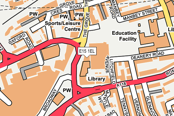
E15 1EL is located in the Stratford electoral ward, within the London borough of Newham and the English Parliamentary constituency of West Ham. The Sub Integrated Care Board (ICB) Location is NHS North East London ICB - A3A8R and the police force is Metropolitan Police. This postcode has been in use since June 2000.


GetTheData
Source: OS OpenMap – Local (Ordnance Survey)
Source: OS VectorMap District (Ordnance Survey)
Licence: Open Government Licence (requires attribution)
| Easting | 539097 |
| Northing | 184586 |
| Latitude | 51.543038 |
| Longitude | 0.004469 |
GetTheData
Source: Open Postcode Geo
Licence: Open Government Licence
| Country | England |
| Postcode District | E15 |
| ➜ E15 open data dashboard ➜ See where E15 is on a map ➜ Where is London? | |
GetTheData
Source: Land Registry Price Paid Data
Licence: Open Government Licence
Elevation or altitude of E15 1EL as distance above sea level:
| Metres | Feet | |
|---|---|---|
| Elevation | 10m | 33ft |
Elevation is measured from the approximate centre of the postcode, to the nearest point on an OS contour line from OS Terrain 50, which has contour spacing of ten vertical metres.
➜ How high above sea level am I? Find the elevation of your current position using your device's GPS.
GetTheData
Source: Open Postcode Elevation
Licence: Open Government Licence
| Ward | Stratford |
| Constituency | West Ham |
GetTheData
Source: ONS Postcode Database
Licence: Open Government Licence
| January 2024 | Violence and sexual offences | On or near Manbey Road | 204m |
| January 2024 | Violence and sexual offences | On or near Elliot Close | 300m |
| January 2024 | Violence and sexual offences | On or near Elliot Close | 300m |
| ➜ Get more crime data in our Crime section | |||
GetTheData
Source: data.police.uk
Licence: Open Government Licence
| Stratford Library (The Grove) | Stratford | 31m |
| Litchfield Avenue (Romford Road) | Stratford | 87m |
| The Grove (E15) | Stratford | 96m |
| Stratford Centre Broadway (Broadway) | Stratford | 142m |
| Manbey Grove (The Grove) | Stratford | 215m |
| Stratford Dlr Station (Station Street) | Stratford | 555m |
| Stratford Underground Station | Stratford | 565m |
| Stratford High Street Dlr Station | Stratford | 661m |
| Stratford International Dlr Station | Stratford | 1,008m |
| Abbey Road Dlr Station | Stratford | 1,237m |
| Maryland Station | 0.4km |
| Stratford (London) Station | 0.6km |
| Stratford International Station | 0.9km |
GetTheData
Source: NaPTAN
Licence: Open Government Licence
Estimated total energy consumption in E15 1EL by fuel type, 2015.
| Consumption (kWh) | 41,350 |
|---|---|
| Meter count | 6 |
| Mean (kWh/meter) | 6,892 |
| Median (kWh/meter) | 4,592 |
GetTheData
Source: Postcode level gas estimates: 2015 (experimental)
Source: Postcode level electricity estimates: 2015 (experimental)
Licence: Open Government Licence
GetTheData
Source: ONS Postcode Database
Licence: Open Government Licence


➜ Get more ratings from the Food Standards Agency
GetTheData
Source: Food Standards Agency
Licence: FSA terms & conditions
| Last Collection | |||
|---|---|---|---|
| Location | Mon-Fri | Sat | Distance |
| Broadway | 17:30 | 11:30 | 157m |
| 117 The Grove E15 | 17:30 | 12:00 | 172m |
| Broadway | 18:30 | 11:30 | 188m |
GetTheData
Source: Dracos
Licence: Creative Commons Attribution-ShareAlike
| Facility | Distance |
|---|---|
| Sarah Bonnell School Deanery Road, London Sports Hall, Outdoor Tennis Courts | 246m |
| Puregym (London Stratford) The Mall, The Stratford Centre, London Health and Fitness Gym | 292m |
| Methodist Church Bryant St Community Centre Bryant Street, Stratford, London Sports Hall | 469m |
GetTheData
Source: Active Places
Licence: Open Government Licence
| School | Phase of Education | Distance |
|---|---|---|
| Stratford Circus Theatre Square, Stratford, London, E15 1BX | Not applicable | 200m |
| Sarah Bonnell School Deanery Road, Stratford, London, E15 4LP | Secondary | 258m |
| East London Independent School Welfare Road, 1c Maryland Park, Stratford, London, E15 4HT | Not applicable | 467m |
GetTheData
Source: Edubase
Licence: Open Government Licence
The below table lists the International Territorial Level (ITL) codes (formerly Nomenclature of Territorial Units for Statistics (NUTS) codes) and Local Administrative Units (LAU) codes for E15 1EL:
| ITL 1 Code | Name |
|---|---|
| TLI | London |
| ITL 2 Code | Name |
| TLI4 | Inner London - East |
| ITL 3 Code | Name |
| TLI41 | Hackney and Newham |
| LAU 1 Code | Name |
| E09000025 | Newham |
GetTheData
Source: ONS Postcode Directory
Licence: Open Government Licence
The below table lists the Census Output Area (OA), Lower Layer Super Output Area (LSOA), and Middle Layer Super Output Area (MSOA) for E15 1EL:
| Code | Name | |
|---|---|---|
| OA | E00018231 | |
| LSOA | E01003618 | Newham 012C |
| MSOA | E02000725 | Newham 012 |
GetTheData
Source: ONS Postcode Directory
Licence: Open Government Licence
| E15 4LJ | Romford Road | 88m |
| E15 1NR | The Grove | 96m |
| E15 4LN | Litchfield Avenue | 101m |
| E15 1NS | The Grove | 117m |
| E15 4LW | Litchfield Avenue | 122m |
| E15 4BT | Mantle Way | 141m |
| E15 4LT | Deanery Road | 148m |
| E15 4BZ | Romford Road | 169m |
| E15 1BJ | Grove Crescent Road | 175m |
| E15 1ES | Lavender Street | 177m |
GetTheData
Source: Open Postcode Geo; Land Registry Price Paid Data
Licence: Open Government Licence