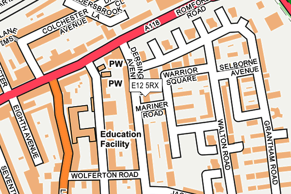
E12 5RX is located in the Little Ilford electoral ward, within the London borough of Newham and the English Parliamentary constituency of East Ham. The Sub Integrated Care Board (ICB) Location is NHS North East London ICB - A3A8R and the police force is Metropolitan Police. This postcode has been in use since January 1980.


GetTheData
Source: OS OpenMap – Local (Ordnance Survey)
Source: OS VectorMap District (Ordnance Survey)
Licence: Open Government Licence (requires attribution)
| Easting | 543013 |
| Northing | 185916 |
| Latitude | 51.554010 |
| Longitude | 0.061413 |
GetTheData
Source: Open Postcode Geo
Licence: Open Government Licence
| Country | England |
| Postcode District | E12 |
| ➜ E12 open data dashboard ➜ See where E12 is on a map ➜ Where is London? | |
GetTheData
Source: Land Registry Price Paid Data
Licence: Open Government Licence
Elevation or altitude of E12 5RX as distance above sea level:
| Metres | Feet | |
|---|---|---|
| Elevation | 10m | 33ft |
Elevation is measured from the approximate centre of the postcode, to the nearest point on an OS contour line from OS Terrain 50, which has contour spacing of ten vertical metres.
➜ How high above sea level am I? Find the elevation of your current position using your device's GPS.
GetTheData
Source: Open Postcode Elevation
Licence: Open Government Licence
| Ward | Little Ilford |
| Constituency | East Ham |
GetTheData
Source: ONS Postcode Database
Licence: Open Government Licence
| January 2024 | Violence and sexual offences | On or near Walton Road | 248m |
| October 2023 | Anti-social behaviour | On or near Walton Road | 248m |
| October 2023 | Violence and sexual offences | On or near Walton Road | 248m |
| ➜ Get more crime data in our Crime section | |||
GetTheData
Source: data.police.uk
Licence: Open Government Licence
| Wolferton Road (Dersingham Avenue) | Little Ilford | 127m |
| Little Ilford Lane | Little Ilford | 135m |
| Dersingham Avenue (Romford Road) | Little Ilford | 147m |
| Little Ilford Lane (Romford Road) | Little Ilford | 151m |
| Wolferton Road (Little Ilford Lane) | Little Ilford | 223m |
| Ilford Station | 0.8km |
| Manor Park Station | 1.1km |
| Woodgrange Park Station | 1.3km |
GetTheData
Source: NaPTAN
Licence: Open Government Licence
GetTheData
Source: ONS Postcode Database
Licence: Open Government Licence


➜ Get more ratings from the Food Standards Agency
GetTheData
Source: Food Standards Agency
Licence: FSA terms & conditions
| Last Collection | |||
|---|---|---|---|
| Location | Mon-Fri | Sat | Distance |
| Cardomom Court | 17:30 | 11:30 | 40m |
| 16 Walter Hurford Parade E12 | 17:00 | 12:00 | 130m |
| Sheringham Avenue | 17:30 | 11:30 | 183m |
GetTheData
Source: Dracos
Licence: Creative Commons Attribution-ShareAlike
| Facility | Distance |
|---|---|
| Jack Cornwell Community Centre Jack Cornwell Street, London Sports Hall | 177m |
| The Gym Group (London Ilford Romford Road) Romford Road, London Health and Fitness Gym | 307m |
| The Froud Centre Toronto Avenue, London Sports Hall | 389m |
GetTheData
Source: Active Places
Licence: Open Government Licence
| School | Phase of Education | Distance |
|---|---|---|
| Sheringham Nursery School & Children's Centre Sheringham Avenue, Manor Park, London, E12 5PB | Nursery | 82m |
| Sheringham Primary School Sheringham Avenue, Manor Park, London, E12 5PB | Primary | 143m |
| Dersingham Primary School Dersingham Avenue, Manor Park, London, Manor Park, Dersingham Avenue, London, E12 5QJ | Primary | 371m |
GetTheData
Source: Edubase
Licence: Open Government Licence
The below table lists the International Territorial Level (ITL) codes (formerly Nomenclature of Territorial Units for Statistics (NUTS) codes) and Local Administrative Units (LAU) codes for E12 5RX:
| ITL 1 Code | Name |
|---|---|
| TLI | London |
| ITL 2 Code | Name |
| TLI4 | Inner London - East |
| ITL 3 Code | Name |
| TLI41 | Hackney and Newham |
| LAU 1 Code | Name |
| E09000025 | Newham |
GetTheData
Source: ONS Postcode Directory
Licence: Open Government Licence
The below table lists the Census Output Area (OA), Lower Layer Super Output Area (LSOA), and Middle Layer Super Output Area (MSOA) for E12 5RX:
| Code | Name | |
|---|---|---|
| OA | E00018067 | |
| LSOA | E01003576 | Newham 002A |
| MSOA | E02000715 | Newham 002 |
GetTheData
Source: ONS Postcode Directory
Licence: Open Government Licence
| E12 5RU | Warrior Square | 38m |
| E12 5QE | Dersingham Avenue | 53m |
| E12 5RP | Warrior Square | 70m |
| E12 5AE | Grantham Road | 76m |
| E12 5NR | Grantham Road | 87m |
| E12 5RR | Warrior Square | 94m |
| E12 5PA | Sheringham Avenue | 104m |
| E12 5RT | Warrior Square | 109m |
| E12 5AH | Grantham Road | 112m |
| E12 5QZ | Grantham Road | 119m |
GetTheData
Source: Open Postcode Geo; Land Registry Price Paid Data
Licence: Open Government Licence