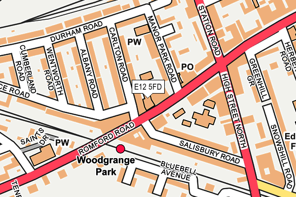
E12 5FD is located in the Manor Park electoral ward, within the London borough of Newham and the English Parliamentary constituency of East Ham. The Sub Integrated Care Board (ICB) Location is NHS North East London ICB - A3A8R and the police force is Metropolitan Police. This postcode has been in use since November 2013.


GetTheData
Source: OS OpenMap – Local (Ordnance Survey)
Source: OS VectorMap District (Ordnance Survey)
Licence: Open Government Licence (requires attribution)
| Easting | 541914 |
| Northing | 185441 |
| Latitude | 51.550020 |
| Longitude | 0.045407 |
GetTheData
Source: Open Postcode Geo
Licence: Open Government Licence
| Country | England |
| Postcode District | E12 |
| ➜ E12 open data dashboard ➜ See where E12 is on a map ➜ Where is London? | |
GetTheData
Source: Land Registry Price Paid Data
Licence: Open Government Licence
Elevation or altitude of E12 5FD as distance above sea level:
| Metres | Feet | |
|---|---|---|
| Elevation | 10m | 33ft |
Elevation is measured from the approximate centre of the postcode, to the nearest point on an OS contour line from OS Terrain 50, which has contour spacing of ten vertical metres.
➜ How high above sea level am I? Find the elevation of your current position using your device's GPS.
GetTheData
Source: Open Postcode Elevation
Licence: Open Government Licence
| Ward | Manor Park |
| Constituency | East Ham |
GetTheData
Source: ONS Postcode Database
Licence: Open Government Licence
| January 2024 | Criminal damage and arson | On or near Clarence Road | 273m |
| January 2024 | Other theft | On or near Clarence Road | 273m |
| January 2024 | Anti-social behaviour | On or near Meanley Road | 402m |
| ➜ Get more crime data in our Crime section | |||
GetTheData
Source: data.police.uk
Licence: Open Government Licence
| High Street North Manor Park (Romford Road) | Manor Park | 102m |
| Woodgrange Park Station (Romford Road) | Manor Park | 152m |
| Romford Road (E12) | Manor Park | 162m |
| Woodgrange Park Station (Romford Road) | Manor Park | 178m |
| Romford Road (E12) | Manor Park | 202m |
| East Ham Underground Station | East Ham | 1,296m |
| Woodgrange Park Station | 0.1km |
| Manor Park Station | 0.3km |
| Wanstead Park Station | 1.3km |
GetTheData
Source: NaPTAN
Licence: Open Government Licence
GetTheData
Source: ONS Postcode Database
Licence: Open Government Licence


➜ Get more ratings from the Food Standards Agency
GetTheData
Source: Food Standards Agency
Licence: FSA terms & conditions
| Last Collection | |||
|---|---|---|---|
| Location | Mon-Fri | Sat | Distance |
| 667 Romford Road E12 | 17:30 | 12:00 | 77m |
| Durham Road | 17:30 | 11:30 | 180m |
| Manor Park Road E12 | 17:30 | 11:30 | 239m |
GetTheData
Source: Dracos
Licence: Creative Commons Attribution-ShareAlike
| Facility | Distance |
|---|---|
| Manor Park Fitness Centre (Closed) High Street North, London Health and Fitness Gym, Studio | 261m |
| Avenue Primary School Meanley Road, London Sports Hall | 334m |
| The Froud Centre Toronto Avenue, London Sports Hall | 851m |
GetTheData
Source: Active Places
Licence: Open Government Licence
| School | Phase of Education | Distance |
|---|---|---|
| Salisbury Primary School 495 High Street North, Manor Park, London, E12 6TH | Primary | 113m |
| Avenue Primary School Meanley Road, Manor Park, London, E12 6AR | Primary | 331m |
| Monega Primary School Monega Road, Manor Park, London, E12 6TT | Primary | 524m |
GetTheData
Source: Edubase
Licence: Open Government Licence
The below table lists the International Territorial Level (ITL) codes (formerly Nomenclature of Territorial Units for Statistics (NUTS) codes) and Local Administrative Units (LAU) codes for E12 5FD:
| ITL 1 Code | Name |
|---|---|
| TLI | London |
| ITL 2 Code | Name |
| TLI4 | Inner London - East |
| ITL 3 Code | Name |
| TLI41 | Hackney and Newham |
| LAU 1 Code | Name |
| E09000025 | Newham |
GetTheData
Source: ONS Postcode Directory
Licence: Open Government Licence
The below table lists the Census Output Area (OA), Lower Layer Super Output Area (LSOA), and Middle Layer Super Output Area (MSOA) for E12 5FD:
| Code | Name | |
|---|---|---|
| OA | E00018099 | |
| LSOA | E01003591 | Newham 004D |
| MSOA | E02000717 | Newham 004 |
GetTheData
Source: ONS Postcode Directory
Licence: Open Government Licence
| E12 5AD | Romford Road | 0m |
| E12 5AF | Romford Road | 37m |
| E12 5BG | Carlton Road | 96m |
| E12 6AA | Salisbury Road | 118m |
| E12 5AB | Manor Park Road | 138m |
| E12 5BE | Albany Road | 141m |
| E12 6AB | Salisbury Road | 142m |
| E12 5AT | Manor Park Road | 145m |
| E7 8AY | Romford Road | 150m |
| E12 5AU | Barnes Close | 172m |
GetTheData
Source: Open Postcode Geo; Land Registry Price Paid Data
Licence: Open Government Licence