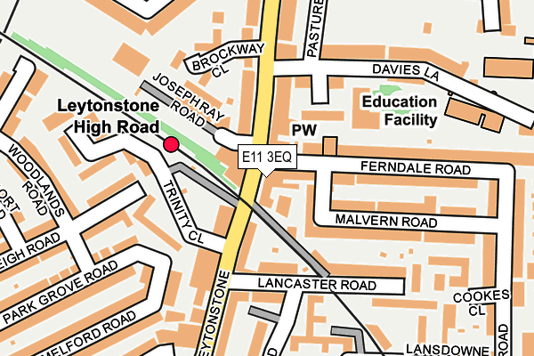
E11 3EQ is located in the Cann Hall electoral ward, within the London borough of Waltham Forest and the English Parliamentary constituency of Leyton and Wanstead. The Sub Integrated Care Board (ICB) Location is NHS North East London ICB - A3A8R and the police force is Metropolitan Police. This postcode has been in use since August 2011.


GetTheData
Source: OS OpenMap – Local (Ordnance Survey)
Source: OS VectorMap District (Ordnance Survey)
Licence: Open Government Licence (requires attribution)
| Easting | 539412 |
| Northing | 186844 |
| Latitude | 51.563249 |
| Longitude | 0.009875 |
GetTheData
Source: Open Postcode Geo
Licence: Open Government Licence
| Country | England |
| Postcode District | E11 |
| ➜ E11 open data dashboard ➜ See where E11 is on a map ➜ Where is London? | |
GetTheData
Source: Land Registry Price Paid Data
Licence: Open Government Licence
Elevation or altitude of E11 3EQ as distance above sea level:
| Metres | Feet | |
|---|---|---|
| Elevation | 20m | 66ft |
Elevation is measured from the approximate centre of the postcode, to the nearest point on an OS contour line from OS Terrain 50, which has contour spacing of ten vertical metres.
➜ How high above sea level am I? Find the elevation of your current position using your device's GPS.
GetTheData
Source: Open Postcode Elevation
Licence: Open Government Licence
| Ward | Cann Hall |
| Constituency | Leyton And Wanstead |
GetTheData
Source: ONS Postcode Database
Licence: Open Government Licence
| January 2024 | Criminal damage and arson | On or near Caradon Close | 161m |
| January 2024 | Violence and sexual offences | On or near Short Road | 304m |
| January 2024 | Anti-social behaviour | On or near Lynn Road | 363m |
| ➜ Get more crime data in our Crime section | |||
GetTheData
Source: data.police.uk
Licence: Open Government Licence
| Leytonstone High Road Station (Leytonstone High Road) | Leytonstone | 48m |
| Leytonstone High Road Station (Leytonstone High Road) | Leytonstone | 69m |
| Vernon Rdleytonstone High Rd (Leytonstone High Road) | Leytonstone | 222m |
| Michael Road (Leytonstone High Road) | Leytonstone | 314m |
| Leytonstone Fire Station (Leytonstone High Road) | Leytonstone | 347m |
| Leytonstone Underground Station | Leytonstone | 576m |
| Leyton Underground Station | Leyton | 1,300m |
| Wanstead Underground Station | Wanstead | 1,879m |
| Leytonstone High Road Station | 0.1km |
| Leyton Midland Road Station | 1.4km |
| Wanstead Park Station | 1.7km |
GetTheData
Source: NaPTAN
Licence: Open Government Licence
GetTheData
Source: ONS Postcode Database
Licence: Open Government Licence


➜ Get more ratings from the Food Standards Agency
GetTheData
Source: Food Standards Agency
Licence: FSA terms & conditions
| Last Collection | |||
|---|---|---|---|
| Location | Mon-Fri | Sat | Distance |
| Joseph Ray Road | 18:30 | 11:30 | 56m |
| Lister Road | 17:30 | 11:30 | 190m |
| High Road Leytonstone | 17:30 | 11:30 | 282m |
GetTheData
Source: Dracos
Licence: Creative Commons Attribution-ShareAlike
| Facility | Distance |
|---|---|
| Mayville Primary School Lincoln Street, London Artificial Grass Pitch | 446m |
| Puregym (London Leytonstone) High Road Leytonstone, High Road Leytonstone, Leytonstone Health and Fitness Gym | 470m |
| Muscle Hut Gym High Road Leytonstone, London Health and Fitness Gym | 483m |
GetTheData
Source: Active Places
Licence: Open Government Licence
| School | Phase of Education | Distance |
|---|---|---|
| Davies Lane Primary School Davies Lane, Leytonstone, London, E11 3DR | Primary | 194m |
| George Tomlinson Primary School Harrington Road, Leytonstone, London, E11 4QN | Primary | 345m |
| Acacia Nursery Cecil Road, Leytonstone, London, E11 3HF | Nursery | 406m |
GetTheData
Source: Edubase
Licence: Open Government Licence
The below table lists the International Territorial Level (ITL) codes (formerly Nomenclature of Territorial Units for Statistics (NUTS) codes) and Local Administrative Units (LAU) codes for E11 3EQ:
| ITL 1 Code | Name |
|---|---|
| TLI | London |
| ITL 2 Code | Name |
| TLI5 | Outer London - East and North East |
| ITL 3 Code | Name |
| TLI53 | Redbridge and Waltham Forest |
| LAU 1 Code | Name |
| E09000031 | Waltham Forest |
GetTheData
Source: ONS Postcode Directory
Licence: Open Government Licence
The below table lists the Census Output Area (OA), Lower Layer Super Output Area (LSOA), and Middle Layer Super Output Area (MSOA) for E11 3EQ:
| Code | Name | |
|---|---|---|
| OA | E00021789 | |
| LSOA | E01004333 | Waltham Forest 024A |
| MSOA | E02000918 | Waltham Forest 024 |
GetTheData
Source: ONS Postcode Directory
Licence: Open Government Licence
| E11 3EE | High Road Leytonstone | 71m |
| E11 4RD | High Road Leytonstone | 74m |
| E11 3DU | Cotton Close | 94m |
| E11 3DH | High Road Leytonstone | 102m |
| E11 4RB | High Road Leytonstone | 109m |
| E11 4TF | Brockway Close | 134m |
| E11 4TG | Brockway Close | 135m |
| E11 3EH | Lancaster Road | 135m |
| E11 3DJ | Malvern Road | 136m |
| E11 4RF | Granleigh Road | 138m |
GetTheData
Source: Open Postcode Geo; Land Registry Price Paid Data
Licence: Open Government Licence