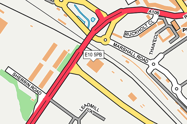
E10 5PB is located in the Leyton electoral ward, within the London borough of Waltham Forest and the English Parliamentary constituency of Leyton and Wanstead. The Sub Integrated Care Board (ICB) Location is NHS North East London ICB - A3A8R and the police force is Metropolitan Police. This postcode has been in use since January 1980.


GetTheData
Source: OS OpenMap – Local (Ordnance Survey)
Source: OS VectorMap District (Ordnance Survey)
Licence: Open Government Licence (requires attribution)
| Easting | 537720 |
| Northing | 185956 |
| Latitude | 51.555687 |
| Longitude | -0.014839 |
GetTheData
Source: Open Postcode Geo
Licence: Open Government Licence
| Country | England |
| Postcode District | E10 |
➜ See where E10 is on a map ➜ Where is London? | |
GetTheData
Source: Land Registry Price Paid Data
Licence: Open Government Licence
Elevation or altitude of E10 5PB as distance above sea level:
| Metres | Feet | |
|---|---|---|
| Elevation | 10m | 33ft |
Elevation is measured from the approximate centre of the postcode, to the nearest point on an OS contour line from OS Terrain 50, which has contour spacing of ten vertical metres.
➜ How high above sea level am I? Find the elevation of your current position using your device's GPS.
GetTheData
Source: Open Postcode Elevation
Licence: Open Government Licence
| Ward | Leyton |
| Constituency | Leyton And Wanstead |
GetTheData
Source: ONS Postcode Database
Licence: Open Government Licence
| Lea Valley Interchange Bus Garage | Leyton | 80m |
| Spitalfields Market | Leyton | 108m |
| Spitalfields Market | Leyton | 131m |
| Oliver Road Ruckholt Road | Leyton | 221m |
| Oliver Road Ruckholt Road | Leyton | 262m |
| Leyton Underground Station | Leyton | 656m |
| Stratford International Dlr Station | Stratford | 1,215m |
| Stratford International Station | 1.3km |
| Hackney Wick Station | 1.5km |
| Leyton Midland Road Station | 1.6km |
GetTheData
Source: NaPTAN
Licence: Open Government Licence
| Percentage of properties with Next Generation Access | 100.0% |
| Percentage of properties with Superfast Broadband | 100.0% |
| Percentage of properties with Ultrafast Broadband | 0.0% |
| Percentage of properties with Full Fibre Broadband | 0.0% |
Superfast Broadband is between 30Mbps and 300Mbps
Ultrafast Broadband is > 300Mbps
| Percentage of properties unable to receive 2Mbps | 0.0% |
| Percentage of properties unable to receive 5Mbps | 0.0% |
| Percentage of properties unable to receive 10Mbps | 0.0% |
| Percentage of properties unable to receive 30Mbps | 0.0% |
GetTheData
Source: Ofcom
Licence: Ofcom Terms of Use (requires attribution)
GetTheData
Source: ONS Postcode Database
Licence: Open Government Licence


➜ Get more ratings from the Food Standards Agency
GetTheData
Source: Food Standards Agency
Licence: FSA terms & conditions
| Last Collection | |||
|---|---|---|---|
| Location | Mon-Fri | Sat | Distance |
| Oliver Road | 17:30 | 11:30 | 340m |
| Asda Stores | 18:30 | 11:30 | 485m |
| Station Road | 17:30 | 11:30 | 632m |
GetTheData
Source: Dracos
Licence: Creative Commons Attribution-ShareAlike
| Risk of E10 5PB flooding from rivers and sea | Medium |
| ➜ E10 5PB flood map | |
GetTheData
Source: Open Flood Risk by Postcode
Licence: Open Government Licence
The below table lists the International Territorial Level (ITL) codes (formerly Nomenclature of Territorial Units for Statistics (NUTS) codes) and Local Administrative Units (LAU) codes for E10 5PB:
| ITL 1 Code | Name |
|---|---|
| TLI | London |
| ITL 2 Code | Name |
| TLI5 | Outer London - East and North East |
| ITL 3 Code | Name |
| TLI53 | Redbridge and Waltham Forest |
| LAU 1 Code | Name |
| E09000031 | Waltham Forest |
GetTheData
Source: ONS Postcode Directory
Licence: Open Government Licence
The below table lists the Census Output Area (OA), Lower Layer Super Output Area (LSOA), and Middle Layer Super Output Area (MSOA) for E10 5PB:
| Code | Name | |
|---|---|---|
| OA | E00022277 | |
| LSOA | E01004430 | Waltham Forest 026D |
| MSOA | E02000920 | Waltham Forest 026 |
GetTheData
Source: ONS Postcode Directory
Licence: Open Government Licence
| E10 5NX | Ruckholt Close | 185m |
| E10 5NL | Dunedin Road | 244m |
| E10 5PJ | Thant Close | 249m |
| E10 5NT | Ruckholt Road | 317m |
| E10 5NW | Adelaide Road | 409m |
| E10 5NJ | Dunedin Road | 415m |
| E10 5LF | Oliver Road | 437m |
| E10 5NU | Ruckholt Road | 447m |
| E10 5NP | Ruckholt Road | 458m |
| E10 5GS | Buckingham Road | 471m |
GetTheData
Source: Open Postcode Geo; Land Registry Price Paid Data
Licence: Open Government Licence