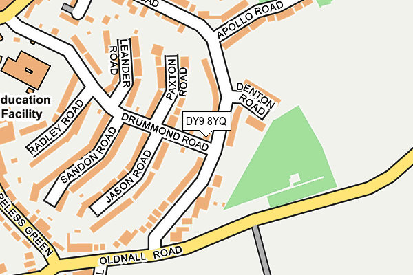
DY9 8YQ lies on Drummond Road in Stourbridge. DY9 8YQ is located in the Cradley and Wollescote electoral ward, within the metropolitan district of Dudley and the English Parliamentary constituency of Stourbridge. The Sub Integrated Care Board (ICB) Location is NHS Black Country ICB - D2P2L and the police force is West Midlands. This postcode has been in use since January 1980.


GetTheData
Source: OS OpenMap – Local (Ordnance Survey)
Source: OS VectorMap District (Ordnance Survey)
Licence: Open Government Licence (requires attribution)
| Easting | 393075 |
| Northing | 283829 |
| Latitude | 52.452386 |
| Longitude | -2.103322 |
GetTheData
Source: Open Postcode Geo
Licence: Open Government Licence
| Street | Drummond Road |
| Town/City | Stourbridge |
| Country | England |
| Postcode District | DY9 |
| ➜ DY9 open data dashboard ➜ See where DY9 is on a map ➜ Where is Stourbridge? | |
GetTheData
Source: Land Registry Price Paid Data
Licence: Open Government Licence
Elevation or altitude of DY9 8YQ as distance above sea level:
| Metres | Feet | |
|---|---|---|
| Elevation | 160m | 525ft |
Elevation is measured from the approximate centre of the postcode, to the nearest point on an OS contour line from OS Terrain 50, which has contour spacing of ten vertical metres.
➜ How high above sea level am I? Find the elevation of your current position using your device's GPS.
GetTheData
Source: Open Postcode Elevation
Licence: Open Government Licence
| Ward | Cradley And Wollescote |
| Constituency | Stourbridge |
GetTheData
Source: ONS Postcode Database
Licence: Open Government Licence
| December 2023 | Violence and sexual offences | On or near Grove Road | 394m |
| December 2023 | Criminal damage and arson | On or near King Street | 499m |
| November 2023 | Violence and sexual offences | On or near King Street | 499m |
| ➜ Drummond Road crime map and outcomes | |||
GetTheData
Source: data.police.uk
Licence: Open Government Licence
| Seymour Rd (Oldnall Rd) | Wynall | 124m |
| Seymour Rd (Oldnall Rd) | Wynall | 124m |
| Grove Rd (Wynall Lane) | Wynall | 296m |
| Belmont Rd (Careless Green) | Wynall | 314m |
| Grove Rd (Wynall Lane) | Wynall | 317m |
| Lye (West Midlands) Station | 1.2km |
| Cradley Heath Station | 2.1km |
| Stourbridge Junction Station | 2.1km |
GetTheData
Source: NaPTAN
Licence: Open Government Licence
| Percentage of properties with Next Generation Access | 100.0% |
| Percentage of properties with Superfast Broadband | 100.0% |
| Percentage of properties with Ultrafast Broadband | 100.0% |
| Percentage of properties with Full Fibre Broadband | 0.0% |
Superfast Broadband is between 30Mbps and 300Mbps
Ultrafast Broadband is > 300Mbps
| Percentage of properties unable to receive 2Mbps | 0.0% |
| Percentage of properties unable to receive 5Mbps | 0.0% |
| Percentage of properties unable to receive 10Mbps | 0.0% |
| Percentage of properties unable to receive 30Mbps | 0.0% |
GetTheData
Source: Ofcom
Licence: Ofcom Terms of Use (requires attribution)
GetTheData
Source: ONS Postcode Database
Licence: Open Government Licence


➜ Get more ratings from the Food Standards Agency
GetTheData
Source: Food Standards Agency
Licence: FSA terms & conditions
| Last Collection | |||
|---|---|---|---|
| Location | Mon-Fri | Sat | Distance |
| Teme Road / Severne Road | 17:15 | 12:00 | 929m |
| Hayes Lane | 18:30 | 10:30 | 959m |
| Lye Post Office | 18:45 | 11:00 | 985m |
GetTheData
Source: Dracos
Licence: Creative Commons Attribution-ShareAlike
| Facility | Distance |
|---|---|
| Wollescote Primary School Drummond Road, Stourbridge Swimming Pool, Grass Pitches | 292m |
| Soccer Zone (Halesowen) Park Road, Halesowen Artificial Grass Pitch | 654m |
| Cradley Town Football Club Beeches View Avenue, Halesowen Grass Pitches | 997m |
GetTheData
Source: Active Places
Licence: Open Government Licence
| School | Phase of Education | Distance |
|---|---|---|
| Wollescote Primary School Drummond Road, Wollescote, Stourbridge, DY9 8YA | Primary | 294m |
| Caslon Primary Community School Beeches View Avenue, Halesowen, B63 2ES | Primary | 951m |
| Hob Green Primary School Hob Green Road, Pedmore Fields, Stourbridge, DY9 9EX | Primary | 1.4km |
GetTheData
Source: Edubase
Licence: Open Government Licence
The below table lists the International Territorial Level (ITL) codes (formerly Nomenclature of Territorial Units for Statistics (NUTS) codes) and Local Administrative Units (LAU) codes for DY9 8YQ:
| ITL 1 Code | Name |
|---|---|
| TLG | West Midlands (England) |
| ITL 2 Code | Name |
| TLG3 | West Midlands |
| ITL 3 Code | Name |
| TLG36 | Dudley |
| LAU 1 Code | Name |
| E08000027 | Dudley |
GetTheData
Source: ONS Postcode Directory
Licence: Open Government Licence
The below table lists the Census Output Area (OA), Lower Layer Super Output Area (LSOA), and Middle Layer Super Output Area (MSOA) for DY9 8YQ:
| Code | Name | |
|---|---|---|
| OA | E00049735 | |
| LSOA | E01009835 | Dudley 032B |
| MSOA | E02002031 | Dudley 032 |
GetTheData
Source: ONS Postcode Directory
Licence: Open Government Licence
| DY9 8YF | Seymour Road | 7m |
| DY9 8XZ | Jason Road | 119m |
| DY9 8YD | Paxton Road | 122m |
| DY9 8YE | Denton Road | 130m |
| DY9 8YB | Leander Road | 179m |
| DY9 8XY | Sandon Road | 180m |
| DY9 8XQ | Oldnall Road | 206m |
| DY9 8XX | Radley Road | 219m |
| DY9 8YG | Apollo Road | 220m |
| DY9 8TB | Seymour Road | 223m |
GetTheData
Source: Open Postcode Geo; Land Registry Price Paid Data
Licence: Open Government Licence