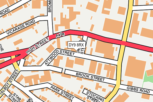
DY9 8RX is located in the Lye and Stourbridge North electoral ward, within the metropolitan district of Dudley and the English Parliamentary constituency of Stourbridge. The Sub Integrated Care Board (ICB) Location is NHS Black Country ICB - D2P2L and the police force is West Midlands. This postcode has been in use since April 2013.


GetTheData
Source: OS OpenMap – Local (Ordnance Survey)
Source: OS VectorMap District (Ordnance Survey)
Licence: Open Government Licence (requires attribution)
| Easting | 392889 |
| Northing | 284414 |
| Latitude | 52.457628 |
| Longitude | -2.106078 |
GetTheData
Source: Open Postcode Geo
Licence: Open Government Licence
| Country | England |
| Postcode District | DY9 |
| ➜ DY9 open data dashboard ➜ See where DY9 is on a map ➜ Where is Stourbridge? | |
GetTheData
Source: Land Registry Price Paid Data
Licence: Open Government Licence
Elevation or altitude of DY9 8RX as distance above sea level:
| Metres | Feet | |
|---|---|---|
| Elevation | 110m | 361ft |
Elevation is measured from the approximate centre of the postcode, to the nearest point on an OS contour line from OS Terrain 50, which has contour spacing of ten vertical metres.
➜ How high above sea level am I? Find the elevation of your current position using your device's GPS.
GetTheData
Source: Open Postcode Elevation
Licence: Open Government Licence
| Ward | Lye And Stourbridge North |
| Constituency | Stourbridge |
GetTheData
Source: ONS Postcode Database
Licence: Open Government Licence
| December 2023 | Criminal damage and arson | On or near King Street | 472m |
| November 2023 | Burglary | On or near Bromley Street | 463m |
| November 2023 | Public order | On or near Bromley Street | 463m |
| ➜ Get more crime data in our Crime section | |||
GetTheData
Source: data.police.uk
Licence: Open Government Licence
| Hayes Lane (The Hayes) | Wynall | 113m |
| Talbot St (High St) | Lye | 143m |
| Hayes Lane (The Hayes) | Wynall | 225m |
| Talbot St (High St) | Lye | 295m |
| Crabbe St (Talbot St) | Lye | 368m |
| Lye (West Midlands) Station | 0.7km |
| Cradley Heath Station | 1.7km |
| Stourbridge Junction Station | 2.2km |
GetTheData
Source: NaPTAN
Licence: Open Government Licence
GetTheData
Source: ONS Postcode Database
Licence: Open Government Licence


➜ Get more ratings from the Food Standards Agency
GetTheData
Source: Food Standards Agency
Licence: FSA terms & conditions
| Last Collection | |||
|---|---|---|---|
| Location | Mon-Fri | Sat | Distance |
| Hayes Lane | 18:30 | 10:30 | 430m |
| Lye Meter Box | 18:30 | 560m | |
| Lye Post Office | 18:45 | 11:00 | 602m |
GetTheData
Source: Dracos
Licence: Creative Commons Attribution-ShareAlike
| Facility | Distance |
|---|---|
| Wollescote Primary School Drummond Road, Stourbridge Swimming Pool, Grass Pitches | 467m |
| Soccer Zone (Halesowen) Park Road, Halesowen Artificial Grass Pitch | 603m |
| Lye Town Football Club Stourbridge Road, Stourbridge Grass Pitches | 958m |
GetTheData
Source: Active Places
Licence: Open Government Licence
| School | Phase of Education | Distance |
|---|---|---|
| Wollescote Primary School Drummond Road, Wollescote, Stourbridge, DY9 8YA | Primary | 457m |
| The Old Park School Thorns Road, Brierley Hill, DY5 2JY | Not applicable | 1.1km |
| Thorns Primary School Thorns Road, Quarry Bank, Brierley Hill, DY5 2JY | Primary | 1.2km |
GetTheData
Source: Edubase
Licence: Open Government Licence
The below table lists the International Territorial Level (ITL) codes (formerly Nomenclature of Territorial Units for Statistics (NUTS) codes) and Local Administrative Units (LAU) codes for DY9 8RX:
| ITL 1 Code | Name |
|---|---|
| TLG | West Midlands (England) |
| ITL 2 Code | Name |
| TLG3 | West Midlands |
| ITL 3 Code | Name |
| TLG36 | Dudley |
| LAU 1 Code | Name |
| E08000027 | Dudley |
GetTheData
Source: ONS Postcode Directory
Licence: Open Government Licence
The below table lists the Census Output Area (OA), Lower Layer Super Output Area (LSOA), and Middle Layer Super Output Area (MSOA) for DY9 8RX:
| Code | Name | |
|---|---|---|
| OA | E00049735 | |
| LSOA | E01009835 | Dudley 032B |
| MSOA | E02002031 | Dudley 032 |
GetTheData
Source: ONS Postcode Directory
Licence: Open Government Licence
| DY9 8RY | Attwood Street | 76m |
| DY9 8NL | The Hayes | 80m |
| DY9 8SN | Brook Street | 98m |
| DY9 8SL | Brook Street | 153m |
| DY9 8SJ | Stocking Street | 155m |
| DY9 8SE | Balds Lane | 164m |
| DY9 8SS | Park Street | 179m |
| DY9 8UE | Talbot Street | 203m |
| DY9 8SR | Park Street | 211m |
| DY9 8SG | Balds Lane | 218m |
GetTheData
Source: Open Postcode Geo; Land Registry Price Paid Data
Licence: Open Government Licence