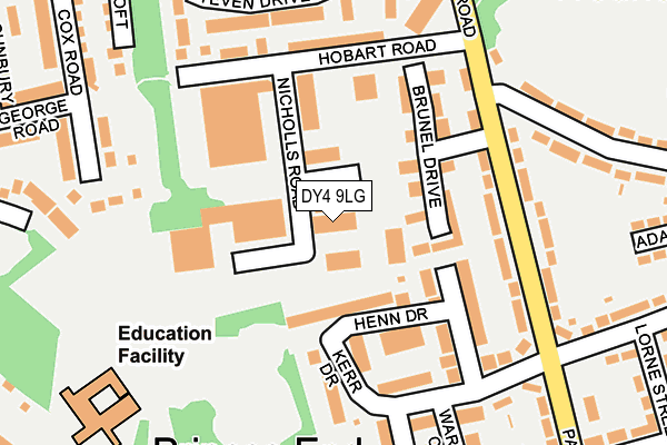
DY4 9LG lies on Nicholls Road in Tipton. DY4 9LG is located in the Princes End electoral ward, within the metropolitan district of Sandwell and the English Parliamentary constituency of West Bromwich West. The Sub Integrated Care Board (ICB) Location is NHS Black Country ICB - D2P2L and the police force is West Midlands. This postcode has been in use since January 1980.


GetTheData
Source: OS OpenMap – Local (Ordnance Survey)
Source: OS VectorMap District (Ordnance Survey)
Licence: Open Government Licence (requires attribution)
| Easting | 395325 |
| Northing | 294100 |
| Latitude | 52.544731 |
| Longitude | -2.070367 |
GetTheData
Source: Open Postcode Geo
Licence: Open Government Licence
| Street | Nicholls Road |
| Town/City | Tipton |
| Country | England |
| Postcode District | DY4 |
| ➜ DY4 open data dashboard ➜ See where DY4 is on a map ➜ Where is Tipton? | |
GetTheData
Source: Land Registry Price Paid Data
Licence: Open Government Licence
Elevation or altitude of DY4 9LG as distance above sea level:
| Metres | Feet | |
|---|---|---|
| Elevation | 150m | 492ft |
Elevation is measured from the approximate centre of the postcode, to the nearest point on an OS contour line from OS Terrain 50, which has contour spacing of ten vertical metres.
➜ How high above sea level am I? Find the elevation of your current position using your device's GPS.
GetTheData
Source: Open Postcode Elevation
Licence: Open Government Licence
| Ward | Princes End |
| Constituency | West Bromwich West |
GetTheData
Source: ONS Postcode Database
Licence: Open Government Licence
| November 2023 | Anti-social behaviour | On or near Henn Drive | 107m |
| September 2023 | Public order | On or near Henn Drive | 107m |
| July 2023 | Violence and sexual offences | On or near Henn Drive | 107m |
| ➜ Get more crime data in our Crime section | |||
GetTheData
Source: data.police.uk
Licence: Open Government Licence
| Brunel Drive (Batmans Hill Rd) | Princes End | 159m |
| Brunel Drive (Batmans Hill Rd) | Princes End | 172m |
| Kerr Drive (Batmans Hill Rd) | Princes End | 207m |
| Steven Drive (Batmans Hill Rd) | Princes End | 247m |
| Parkes Lane (Richards Rd) | Princes End | 257m |
| Bradley Lane (Midland Metro Stop) (Bradley Lane) | Lower Bradley | 1,504m |
| Coseley Station | 1km |
| Tipton Station | 1.6km |
| Dudley Port Station | 2.6km |
GetTheData
Source: NaPTAN
Licence: Open Government Licence
GetTheData
Source: ONS Postcode Database
Licence: Open Government Licence


➜ Get more ratings from the Food Standards Agency
GetTheData
Source: Food Standards Agency
Licence: FSA terms & conditions
| Last Collection | |||
|---|---|---|---|
| Location | Mon-Fri | Sat | Distance |
| Dimmocks Avenue | 17:00 | 11:00 | 525m |
| Newhall Street | 17:30 | 11:00 | 542m |
| Church Road P.o. Box | 17:00 | 12:00 | 694m |
GetTheData
Source: Dracos
Licence: Creative Commons Attribution-ShareAlike
| Facility | Distance |
|---|---|
| Wallbrook Primary Academy Bradleys Lane, Bilston Grass Pitches | 249m |
| Dominator Gym High Street, Princes End, Tipton Health and Fitness Gym | 477m |
| Coseley Cricket Club Church Road, Bilston Grass Pitches | 658m |
GetTheData
Source: Active Places
Licence: Open Government Licence
| School | Phase of Education | Distance |
|---|---|---|
| Wallbrook Primary Academy Off Bradleys Lane, Coseley, Bilston, WV14 8YP | Primary | 249m |
| Christ Church CofE Primary School Church Road, Coseley, Bilston, WV14 8YB | Primary | 585m |
| Wednesbury Oak Academy Greenacre Road, Tipton, DY4 0AR | Primary | 882m |
GetTheData
Source: Edubase
Licence: Open Government Licence
The below table lists the International Territorial Level (ITL) codes (formerly Nomenclature of Territorial Units for Statistics (NUTS) codes) and Local Administrative Units (LAU) codes for DY4 9LG:
| ITL 1 Code | Name |
|---|---|
| TLG | West Midlands (England) |
| ITL 2 Code | Name |
| TLG3 | West Midlands |
| ITL 3 Code | Name |
| TLG37 | Sandwell |
| LAU 1 Code | Name |
| E08000028 | Sandwell |
GetTheData
Source: ONS Postcode Directory
Licence: Open Government Licence
The below table lists the Census Output Area (OA), Lower Layer Super Output Area (LSOA), and Middle Layer Super Output Area (MSOA) for DY4 9LG:
| Code | Name | |
|---|---|---|
| OA | E00050744 | |
| LSOA | E01010036 | Sandwell 007D |
| MSOA | E02002049 | Sandwell 007 |
GetTheData
Source: ONS Postcode Directory
Licence: Open Government Licence
| DY4 9LY | Brunel Drive | 90m |
| DY4 9NN | Henn Drive | 112m |
| DY4 9LA | Batmans Hill Road | 140m |
| DY4 9NP | Kerr Drive | 149m |
| DY4 9LZ | Hobart Road | 161m |
| DY4 9LB | Batmans Hill Road | 186m |
| WV14 8YS | Steven Drive | 188m |
| WV14 8YU | Jenny Close | 251m |
| WV14 8YX | Lilian Grove | 254m |
| DY4 9NW | Waring Close | 254m |
GetTheData
Source: Open Postcode Geo; Land Registry Price Paid Data
Licence: Open Government Licence