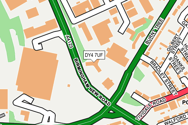
DY4 7UF is located in the Tipton Green electoral ward, within the metropolitan district of Sandwell and the English Parliamentary constituency of West Bromwich West. The Sub Integrated Care Board (ICB) Location is NHS Black Country ICB - D2P2L and the police force is West Midlands. This postcode has been in use since October 1985.


GetTheData
Source: OS OpenMap – Local (Ordnance Survey)
Source: OS VectorMap District (Ordnance Survey)
Licence: Open Government Licence (requires attribution)
| Easting | 395840 |
| Northing | 290792 |
| Latitude | 52.515012 |
| Longitude | -2.062725 |
GetTheData
Source: Open Postcode Geo
Licence: Open Government Licence
| Country | England |
| Postcode District | DY4 |
| ➜ DY4 open data dashboard ➜ See where DY4 is on a map ➜ Where is Tipton? | |
GetTheData
Source: Land Registry Price Paid Data
Licence: Open Government Licence
Elevation or altitude of DY4 7UF as distance above sea level:
| Metres | Feet | |
|---|---|---|
| Elevation | 160m | 525ft |
Elevation is measured from the approximate centre of the postcode, to the nearest point on an OS contour line from OS Terrain 50, which has contour spacing of ten vertical metres.
➜ How high above sea level am I? Find the elevation of your current position using your device's GPS.
GetTheData
Source: Open Postcode Elevation
Licence: Open Government Licence
| Ward | Tipton Green |
| Constituency | West Bromwich West |
GetTheData
Source: ONS Postcode Database
Licence: Open Government Licence
| January 2024 | Criminal damage and arson | On or near Bradley Street | 139m |
| December 2023 | Vehicle crime | On or near Bradley Street | 139m |
| August 2023 | Violence and sexual offences | On or near Bradley Street | 139m |
| ➜ Get more crime data in our Crime section | |||
GetTheData
Source: data.police.uk
Licence: Open Government Licence
| Hopkins St (Burnt Tree) | Tividale Hall | 99m |
| Hopkins St (Burnt Tree) | Tividale Hall | 149m |
| Burnt Tree Island (Tividale Rd) | Burnt Tree | 171m |
| Hopkins St (Tividale Rd) | Tividale Hall | 222m |
| Burnt Tree (Birmingham Rd) | Burnt Tree | 230m |
| Dudley Port Station | 1.4km |
| Tipton Station | 1.7km |
| Sandwell & Dudley Station | 3.5km |
GetTheData
Source: NaPTAN
Licence: Open Government Licence
GetTheData
Source: ONS Postcode Database
Licence: Open Government Licence


➜ Get more ratings from the Food Standards Agency
GetTheData
Source: Food Standards Agency
Licence: FSA terms & conditions
| Last Collection | |||
|---|---|---|---|
| Location | Mon-Fri | Sat | Distance |
| Elm Terrace Post Office | 17:30 | 12:00 | 765m |
| Highfield Road | 17:30 | 11:00 | 770m |
| Green Park Road | 17:30 | 11:00 | 966m |
GetTheData
Source: Dracos
Licence: Creative Commons Attribution-ShareAlike
| Facility | Distance |
|---|---|
| Village Gym (Dudley) Castlegate Drive, Dudley Swimming Pool, Health and Fitness Gym, Studio, Squash Courts | 403m |
| Burnt Tree Primary School Hill Road, Tividale, Oldbury Grass Pitches, Sports Hall, Outdoor Tennis Courts, Studio | 486m |
| St Thomas Community Network (Closed) Beechwood Road, Dudley Sports Hall | 633m |
GetTheData
Source: Active Places
Licence: Open Government Licence
| School | Phase of Education | Distance |
|---|---|---|
| Burnt Tree Primary School Hill Road, Tividale, Oldbury, B69 2LN | Primary | 486m |
| Beechwood Church of England Primary School Beechwood Road, Dudley, DY2 7QA | Primary | 682m |
| St Joseph's Catholic Primary School Hillcrest Road, Dudley, DY2 7PW | Primary | 772m |
GetTheData
Source: Edubase
Licence: Open Government Licence
The below table lists the International Territorial Level (ITL) codes (formerly Nomenclature of Territorial Units for Statistics (NUTS) codes) and Local Administrative Units (LAU) codes for DY4 7UF:
| ITL 1 Code | Name |
|---|---|
| TLG | West Midlands (England) |
| ITL 2 Code | Name |
| TLG3 | West Midlands |
| ITL 3 Code | Name |
| TLG37 | Sandwell |
| LAU 1 Code | Name |
| E08000028 | Sandwell |
GetTheData
Source: ONS Postcode Directory
Licence: Open Government Licence
The below table lists the Census Output Area (OA), Lower Layer Super Output Area (LSOA), and Middle Layer Super Output Area (MSOA) for DY4 7UF:
| Code | Name | |
|---|---|---|
| OA | E00050929 | |
| LSOA | E01010072 | Sandwell 021D |
| MSOA | E02002063 | Sandwell 021 |
GetTheData
Source: ONS Postcode Directory
Licence: Open Government Licence
| DY4 7TZ | Burnt Tree | 113m |
| DY4 7TA | Bradley Street | 122m |
| DY4 7TD | Orchard Street | 129m |
| DY4 7SZ | Gilbert Street | 179m |
| DY4 7TE | Tividale Road | 182m |
| DY4 7TY | Burnt Tree | 211m |
| B69 2LG | Tividale Road | 223m |
| DY4 7ST | Hopkins Street | 251m |
| DY4 7TF | Tividale Road | 259m |
| DY1 4RF | Birmingham Road | 262m |
GetTheData
Source: Open Postcode Geo; Land Registry Price Paid Data
Licence: Open Government Licence