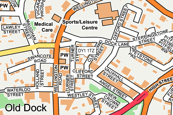
DY1 1TZ lies on Cleveland Street in Dudley. DY1 1TZ is located in the St James's electoral ward, within the metropolitan district of Dudley and the English Parliamentary constituency of Dudley North. The Sub Integrated Care Board (ICB) Location is NHS Black Country ICB - D2P2L and the police force is West Midlands. This postcode has been in use since February 1990.


GetTheData
Source: OS OpenMap – Local (Ordnance Survey)
Source: OS VectorMap District (Ordnance Survey)
Licence: Open Government Licence (requires attribution)
| Easting | 393725 |
| Northing | 290007 |
| Latitude | 52.507935 |
| Longitude | -2.093877 |
GetTheData
Source: Open Postcode Geo
Licence: Open Government Licence
| Street | Cleveland Street |
| Town/City | Dudley |
| Country | England |
| Postcode District | DY1 |
| ➜ DY1 open data dashboard ➜ See where DY1 is on a map ➜ Where is Dudley? | |
GetTheData
Source: Land Registry Price Paid Data
Licence: Open Government Licence
Elevation or altitude of DY1 1TZ as distance above sea level:
| Metres | Feet | |
|---|---|---|
| Elevation | 190m | 623ft |
Elevation is measured from the approximate centre of the postcode, to the nearest point on an OS contour line from OS Terrain 50, which has contour spacing of ten vertical metres.
➜ How high above sea level am I? Find the elevation of your current position using your device's GPS.
GetTheData
Source: Open Postcode Elevation
Licence: Open Government Licence
| Ward | St James's |
| Constituency | Dudley North |
GetTheData
Source: ONS Postcode Database
Licence: Open Government Licence
| January 2024 | Other theft | On or near Westley Street | 140m |
| January 2024 | Criminal damage and arson | On or near Edward Street | 307m |
| January 2024 | Violence and sexual offences | On or near Wolverhampton Street | 433m |
| ➜ Cleveland Street crime map and outcomes | |||
GetTheData
Source: data.police.uk
Licence: Open Government Licence
| Dock Lane (Wellington Rd) | Eve Hill | 102m |
| Dock Lane (Wellington Rd) | Eve Hill | 142m |
| Scotts Green Cemetery (Queens Cross) | Blowers Green | 218m |
| Maughan St (Russells Hall Rd) | Eve Hill | 231m |
| Maughan St (Russells Hall Rd) | Eve Hill | 238m |
| Tipton Station | 3.2km |
| Dudley Port Station | 3.5km |
| Coseley Station | 4.2km |
GetTheData
Source: NaPTAN
Licence: Open Government Licence
GetTheData
Source: ONS Postcode Database
Licence: Open Government Licence


➜ Get more ratings from the Food Standards Agency
GetTheData
Source: Food Standards Agency
Licence: FSA terms & conditions
| Last Collection | |||
|---|---|---|---|
| Location | Mon-Fri | Sat | Distance |
| Dudley Post Office | 19:00 | 12:00 | 538m |
| Waverley Street | 17:30 | 11:00 | 624m |
| Lister Road | 17:30 | 11:00 | 959m |
GetTheData
Source: Dracos
Licence: Creative Commons Attribution-ShareAlike
| Facility | Distance |
|---|---|
| Dudley Leisure Centre (Closed) Wellington Road, Dudley Sports Hall, Swimming Pool, Health and Fitness Gym, Squash Courts | 181m |
| Unique Fitness For Ladies Only (Closed) Wellington Road, Dudley Health and Fitness Gym | 249m |
| Grange Park Himley Road, Dudley Grass Pitches | 562m |
GetTheData
Source: Active Places
Licence: Open Government Licence
| School | Phase of Education | Distance |
|---|---|---|
| Jesson's CofE Primary School (VA) School Street, Dudley, DY1 2AQ | Primary | 372m |
| Blowers Green Primary School Blowers Green Road, Dudley, DY2 8UZ | Primary | 386m |
| St James Academy St James's Road, Dudley, DY1 3JE | Secondary | 603m |
GetTheData
Source: Edubase
Licence: Open Government Licence
The below table lists the International Territorial Level (ITL) codes (formerly Nomenclature of Territorial Units for Statistics (NUTS) codes) and Local Administrative Units (LAU) codes for DY1 1TZ:
| ITL 1 Code | Name |
|---|---|
| TLG | West Midlands (England) |
| ITL 2 Code | Name |
| TLG3 | West Midlands |
| ITL 3 Code | Name |
| TLG36 | Dudley |
| LAU 1 Code | Name |
| E08000027 | Dudley |
GetTheData
Source: ONS Postcode Directory
Licence: Open Government Licence
The below table lists the Census Output Area (OA), Lower Layer Super Output Area (LSOA), and Middle Layer Super Output Area (MSOA) for DY1 1TZ:
| Code | Name | |
|---|---|---|
| OA | E00049996 | |
| LSOA | E01009885 | Dudley 011D |
| MSOA | E02002010 | Dudley 011 |
GetTheData
Source: ONS Postcode Directory
Licence: Open Government Licence
| DY1 1TX | Turner Street | 41m |
| DY1 1TD | Charlotte Street | 57m |
| DY1 1UB | Wellington Road | 76m |
| DY1 1SZ | Ludgate Street | 94m |
| DY1 1RB | Wellington Road | 134m |
| DY1 1TS | Westley Street | 140m |
| DY1 1RD | Wellington Road | 148m |
| DY1 1SN | Dock Lane | 153m |
| DY1 1TL | New Crown Street | 161m |
| DY1 1TU | Colsyll Gardens | 188m |
GetTheData
Source: Open Postcode Geo; Land Registry Price Paid Data
Licence: Open Government Licence