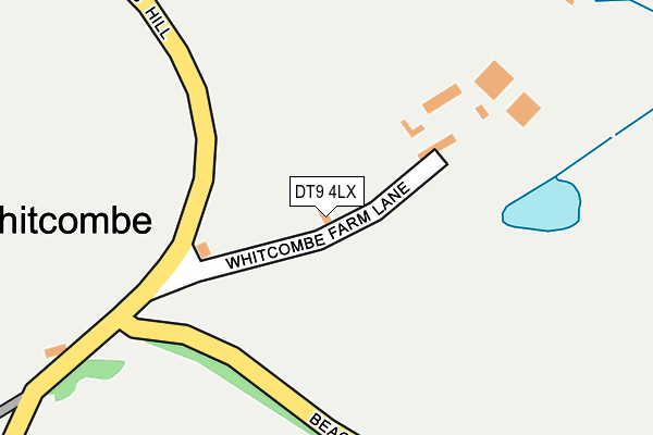
DT9 4LX is in Corton Denham, Sherborne. DT9 4LX is located in the Blackmoor Vale electoral ward, within the unitary authority of Somerset and the English Parliamentary constituency of Somerton and Frome. The Sub Integrated Care Board (ICB) Location is NHS Somerset ICB - 11X and the police force is Avon and Somerset. This postcode has been in use since January 1980.


GetTheData
Source: OS OpenMap – Local (Ordnance Survey)
Source: OS VectorMap District (Ordnance Survey)
Licence: Open Government Licence (requires attribution)
| Easting | 363281 |
| Northing | 123723 |
| Latitude | 51.011707 |
| Longitude | -2.524782 |
GetTheData
Source: Open Postcode Geo
Licence: Open Government Licence
| Locality | Corton Denham |
| Town/City | Sherborne |
| Country | England |
| Postcode District | DT9 |
| ➜ DT9 open data dashboard ➜ See where DT9 is on a map ➜ Where is Whitcombe? | |
GetTheData
Source: Land Registry Price Paid Data
Licence: Open Government Licence
Elevation or altitude of DT9 4LX as distance above sea level:
| Metres | Feet | |
|---|---|---|
| Elevation | 110m | 361ft |
Elevation is measured from the approximate centre of the postcode, to the nearest point on an OS contour line from OS Terrain 50, which has contour spacing of ten vertical metres.
➜ How high above sea level am I? Find the elevation of your current position using your device's GPS.
GetTheData
Source: Open Postcode Elevation
Licence: Open Government Licence
| Ward | Blackmoor Vale |
| Constituency | Somerton And Frome |
GetTheData
Source: ONS Postcode Database
Licence: Open Government Licence
| South Cadbury Road | Sutton Montis | 1,256m |
| Queen's Arms | Corton Denham | 1,268m |
| Queen's Arms | Corton Denham | 1,269m |
| South Cadbury Road | Sutton Montis | 1,270m |
GetTheData
Source: NaPTAN
Licence: Open Government Licence
➜ Broadband speed and availability dashboard for DT9 4LX
| Percentage of properties with Next Generation Access | 100.0% |
| Percentage of properties with Superfast Broadband | 0.0% |
| Percentage of properties with Ultrafast Broadband | 0.0% |
| Percentage of properties with Full Fibre Broadband | 0.0% |
Superfast Broadband is between 30Mbps and 300Mbps
Ultrafast Broadband is > 300Mbps
| Median download speed | 17.4Mbps |
| Average download speed | 16.7Mbps |
| Maximum download speed | 24.19Mbps |
| Median upload speed | 1.2Mbps |
| Average upload speed | 1.2Mbps |
| Maximum upload speed | 2.24Mbps |
| Percentage of properties unable to receive 2Mbps | 0.0% |
| Percentage of properties unable to receive 5Mbps | 0.0% |
| Percentage of properties unable to receive 10Mbps | 0.0% |
| Percentage of properties unable to receive 30Mbps | 100.0% |
➜ Broadband speed and availability dashboard for DT9 4LX
GetTheData
Source: Ofcom
Licence: Ofcom Terms of Use (requires attribution)
Estimated total energy consumption in DT9 4LX by fuel type, 2015.
| Consumption (kWh) | 24,610 |
|---|---|
| Meter count | 6 |
| Mean (kWh/meter) | 4,102 |
| Median (kWh/meter) | 4,542 |
GetTheData
Source: Postcode level gas estimates: 2015 (experimental)
Source: Postcode level electricity estimates: 2015 (experimental)
Licence: Open Government Licence
GetTheData
Source: ONS Postcode Database
Licence: Open Government Licence

➜ Get more ratings from the Food Standards Agency
GetTheData
Source: Food Standards Agency
Licence: FSA terms & conditions
| Last Collection | |||
|---|---|---|---|
| Location | Mon-Fri | Sat | Distance |
| South Cadbury | 16:15 | 09:00 | 1,885m |
| Hazelgrove Service Station | 16:15 | 12:00 | 4,057m |
GetTheData
Source: Dracos
Licence: Creative Commons Attribution-ShareAlike
| Facility | Distance |
|---|---|
| Sandford Orcas Village Hall Sandford Orcas, Sherborne Sports Hall | 3.1km |
| North Cadbury Tennis Club North Cadbury, Yeovil Outdoor Tennis Courts | 3.5km |
| Sparkford Cricket Club Brains Lane, Sparkford, Yeovil Grass Pitches | 3.8km |
GetTheData
Source: Active Places
Licence: Open Government Licence
| School | Phase of Education | Distance |
|---|---|---|
| Charlton Horethorne Church of England Primary School Charlton Horethorne, Sherborne, DT9 4NL | Primary | 3.2km |
| Countess Gytha Primary School West Camel Road, Queen Camel, Yeovil, BA22 7FF | Primary | 3.8km |
| North Cadbury Church of England Primary School Cary Road, North Cadbury, Yeovil, BA22 7DE | Primary | 3.9km |
GetTheData
Source: Edubase
Licence: Open Government Licence
The below table lists the International Territorial Level (ITL) codes (formerly Nomenclature of Territorial Units for Statistics (NUTS) codes) and Local Administrative Units (LAU) codes for DT9 4LX:
| ITL 1 Code | Name |
|---|---|
| TLK | South West (England) |
| ITL 2 Code | Name |
| TLK2 | Dorset and Somerset |
| ITL 3 Code | Name |
| TLK23 | Somerset CC |
| LAU 1 Code | Name |
| E07000189 | South Somerset |
GetTheData
Source: ONS Postcode Directory
Licence: Open Government Licence
The below table lists the Census Output Area (OA), Lower Layer Super Output Area (LSOA), and Middle Layer Super Output Area (MSOA) for DT9 4LX:
| Code | Name | |
|---|---|---|
| OA | E00148511 | |
| LSOA | E01029155 | South Somerset 005A |
| MSOA | E02006079 | South Somerset 005 |
GetTheData
Source: ONS Postcode Directory
Licence: Open Government Licence
| DT9 4LT | 638m | |
| DT9 4LS | 871m | |
| BA22 7HG | 875m | |
| BA22 7HD | 1105m | |
| DT9 4LR | 1190m | |
| DT9 4LN | 1196m | |
| BA22 7HF | 1215m | |
| BA22 7HQ | 1291m | |
| DT9 4LP | Middle Ridge Lane | 1292m |
| BA22 7HE | 1302m |
GetTheData
Source: Open Postcode Geo; Land Registry Price Paid Data
Licence: Open Government Licence