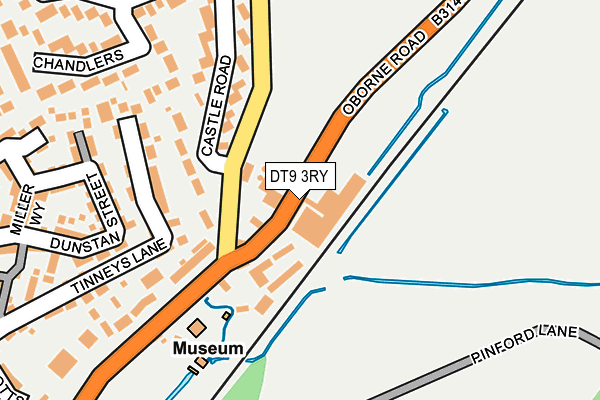
DT9 3RY is located in the Sherborne East electoral ward, within the unitary authority of Dorset and the English Parliamentary constituency of West Dorset. The Sub Integrated Care Board (ICB) Location is NHS Dorset ICB - 11J and the police force is Dorset. This postcode has been in use since January 1980.


GetTheData
Source: OS OpenMap – Local (Ordnance Survey)
Source: OS VectorMap District (Ordnance Survey)
Licence: Open Government Licence (requires attribution)
| Easting | 364704 |
| Northing | 117062 |
| Latitude | 50.951902 |
| Longitude | -2.503850 |
GetTheData
Source: Open Postcode Geo
Licence: Open Government Licence
| Country | England |
| Postcode District | DT9 |
| ➜ DT9 open data dashboard ➜ See where DT9 is on a map ➜ Where is Sherborne? | |
GetTheData
Source: Land Registry Price Paid Data
Licence: Open Government Licence
Elevation or altitude of DT9 3RY as distance above sea level:
| Metres | Feet | |
|---|---|---|
| Elevation | 70m | 230ft |
Elevation is measured from the approximate centre of the postcode, to the nearest point on an OS contour line from OS Terrain 50, which has contour spacing of ten vertical metres.
➜ How high above sea level am I? Find the elevation of your current position using your device's GPS.
GetTheData
Source: Open Postcode Elevation
Licence: Open Government Licence
| Ward | Sherborne East |
| Constituency | West Dorset |
GetTheData
Source: ONS Postcode Database
Licence: Open Government Licence
TOLL COTTAGE, OBORNE ROAD, SHERBORNE, DT9 3RY 2021 25 MAR £380,000 |
GetTheData
Source: HM Land Registry Price Paid Data
Licence: Contains HM Land Registry data © Crown copyright and database right 2024. This data is licensed under the Open Government Licence v3.0.
| January 2024 | Violence and sexual offences | On or near Knotts Paddock | 352m |
| October 2023 | Burglary | On or near Knotts Paddock | 352m |
| September 2023 | Burglary | On or near Knotts Paddock | 352m |
| ➜ Get more crime data in our Crime section | |||
GetTheData
Source: data.police.uk
Licence: Open Government Licence
| Castleton Road (Oborne Road) | Oborne | 348m |
| Castleton Road | Oborne | 356m |
| Tinneys Lane (Newland) | Sherborne | 490m |
| The Surgery (North Road) | Sherborne | 649m |
| St Swithins Close | Sherborne | 673m |
| Sherborne Station | 1.1km |
GetTheData
Source: NaPTAN
Licence: Open Government Licence
| Percentage of properties with Next Generation Access | 100.0% |
| Percentage of properties with Superfast Broadband | 100.0% |
| Percentage of properties with Ultrafast Broadband | 0.0% |
| Percentage of properties with Full Fibre Broadband | 0.0% |
Superfast Broadband is between 30Mbps and 300Mbps
Ultrafast Broadband is > 300Mbps
| Percentage of properties unable to receive 2Mbps | 0.0% |
| Percentage of properties unable to receive 5Mbps | 0.0% |
| Percentage of properties unable to receive 10Mbps | 0.0% |
| Percentage of properties unable to receive 30Mbps | 0.0% |
GetTheData
Source: Ofcom
Licence: Ofcom Terms of Use (requires attribution)
GetTheData
Source: ONS Postcode Database
Licence: Open Government Licence

➜ Get more ratings from the Food Standards Agency
GetTheData
Source: Food Standards Agency
Licence: FSA terms & conditions
| Last Collection | |||
|---|---|---|---|
| Location | Mon-Fri | Sat | Distance |
| Granville Way | 17:00 | 12:45 | 431m |
| Long Street | 17:00 | 12:45 | 489m |
| Greenhill | 17:30 | 12:30 | 934m |
GetTheData
Source: Dracos
Licence: Creative Commons Attribution-ShareAlike
| Facility | Distance |
|---|---|
| Sherborne Area Youth And Community Centre Tinneys Lane, Sherborne Sports Hall, Grass Pitches, Outdoor Tennis Courts | 436m |
| Sherborne Primary School Harbour Way, Sherborne Grass Pitches | 751m |
| Gryphon Sports Centre Bristol Road, Sherborne Sports Hall, Health and Fitness Gym, Grass Pitches, Studio, Squash Courts, Artificial Grass Pitch, Outdoor Tennis Courts | 1km |
GetTheData
Source: Active Places
Licence: Open Government Licence
| School | Phase of Education | Distance |
|---|---|---|
| Sherborne Primary School Harbour Way, Sherborne, DT9 4AJ | Primary | 756m |
| Harbour Vale School Simons Road, Sherborne, DT9 4DN | Not applicable | 785m |
| Sherborne School Abbey Road, Sherborne, DT9 3AP | Not applicable | 1.1km |
GetTheData
Source: Edubase
Licence: Open Government Licence
The below table lists the International Territorial Level (ITL) codes (formerly Nomenclature of Territorial Units for Statistics (NUTS) codes) and Local Administrative Units (LAU) codes for DT9 3RY:
| ITL 1 Code | Name |
|---|---|
| TLK | South West (England) |
| ITL 2 Code | Name |
| TLK2 | Dorset and Somerset |
| ITL 3 Code | Name |
| TLK25 | Dorset |
| LAU 1 Code | Name |
| E06000059 | Dorset |
GetTheData
Source: ONS Postcode Directory
Licence: Open Government Licence
The below table lists the Census Output Area (OA), Lower Layer Super Output Area (LSOA), and Middle Layer Super Output Area (MSOA) for DT9 3RY:
| Code | Name | |
|---|---|---|
| OA | E00104202 | |
| LSOA | E01020542 | West Dorset 001A |
| MSOA | E02004269 | West Dorset 001 |
GetTheData
Source: ONS Postcode Directory
Licence: Open Government Licence
| DT9 3RZ | Waterloo Terrace | 118m |
| DT9 3RX | Oborne Road | 163m |
| DT9 3RW | Castle Road | 202m |
| DT9 3FD | Castleton Court | 216m |
| DT9 3SF | Francis Walk | 232m |
| DT9 3SE | Dunstan Street | 241m |
| DT9 3RP | Castle Road | 244m |
| DT9 3DY | Tinneys Lane | 254m |
| DT9 3RT | Chandlers | 257m |
| DT9 3SQ | Lush Path | 263m |
GetTheData
Source: Open Postcode Geo; Land Registry Price Paid Data
Licence: Open Government Licence