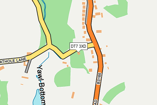
DT7 3XD lies on Cathole Lane in Uplyme, Lyme Regis. DT7 3XD is located in the Trinity electoral ward, within the local authority district of East Devon and the English Parliamentary constituency of Tiverton and Honiton. The Sub Integrated Care Board (ICB) Location is NHS Devon ICB - 15N and the police force is Devon & Cornwall. This postcode has been in use since January 1980.


GetTheData
Source: OS OpenMap – Local (Ordnance Survey)
Source: OS VectorMap District (Ordnance Survey)
Licence: Open Government Licence (requires attribution)
| Easting | 331872 |
| Northing | 94343 |
| Latitude | 50.744678 |
| Longitude | -2.966961 |
GetTheData
Source: Open Postcode Geo
Licence: Open Government Licence
| Street | Cathole Lane |
| Locality | Uplyme |
| Town/City | Lyme Regis |
| Country | England |
| Postcode District | DT7 |
| ➜ DT7 open data dashboard ➜ See where DT7 is on a map ➜ Where is Yawl? | |
GetTheData
Source: Land Registry Price Paid Data
Licence: Open Government Licence
Elevation or altitude of DT7 3XD as distance above sea level:
| Metres | Feet | |
|---|---|---|
| Elevation | 100m | 328ft |
Elevation is measured from the approximate centre of the postcode, to the nearest point on an OS contour line from OS Terrain 50, which has contour spacing of ten vertical metres.
➜ How high above sea level am I? Find the elevation of your current position using your device's GPS.
GetTheData
Source: Open Postcode Elevation
Licence: Open Government Licence
| Ward | Trinity |
| Constituency | Tiverton And Honiton |
GetTheData
Source: ONS Postcode Database
Licence: Open Government Licence
| February 2021 | Anti-social behaviour | On or near Lyme Road | 230m |
| ➜ Cathole Lane crime map and outcomes | |||
GetTheData
Source: data.police.uk
Licence: Open Government Licence
| Cathole Lane | Yawl | 70m |
| Cathole Lane | Yawl | 76m |
| Lime Kiln Lane | Yawl | 584m |
| Post Box | Yawl | 586m |
| Talbot Arms | Uplyme | 1,203m |
| Axminster Station | 4.7km |
GetTheData
Source: NaPTAN
Licence: Open Government Licence
| Percentage of properties with Next Generation Access | 100.0% |
| Percentage of properties with Superfast Broadband | 0.0% |
| Percentage of properties with Ultrafast Broadband | 0.0% |
| Percentage of properties with Full Fibre Broadband | 0.0% |
Superfast Broadband is between 30Mbps and 300Mbps
Ultrafast Broadband is > 300Mbps
| Percentage of properties unable to receive 2Mbps | 0.0% |
| Percentage of properties unable to receive 5Mbps | 0.0% |
| Percentage of properties unable to receive 10Mbps | 0.0% |
| Percentage of properties unable to receive 30Mbps | 100.0% |
GetTheData
Source: Ofcom
Licence: Ofcom Terms of Use (requires attribution)
GetTheData
Source: ONS Postcode Database
Licence: Open Government Licence


➜ Get more ratings from the Food Standards Agency
GetTheData
Source: Food Standards Agency
Licence: FSA terms & conditions
| Last Collection | |||
|---|---|---|---|
| Location | Mon-Fri | Sat | Distance |
| Raymonds Hill Post Office | 17:00 | 11:00 | 2,010m |
| Crewkerne Road | 17:00 | 10:00 | 2,429m |
| Monkton Wild | 11:00 | 09:00 | 2,810m |
GetTheData
Source: Dracos
Licence: Creative Commons Attribution-ShareAlike
| Facility | Distance |
|---|---|
| King George V Playing Field (Uplyme) Lyme Road, Uplyme, Lyme Regis Outdoor Tennis Courts, Grass Pitches | 1.1km |
| Uplyme Football Club Venlake Lane, Uplyme Grass Pitches | 1.2km |
| The Woodroffe School Uplyme Road, Lyme Regis Sports Hall, Health and Fitness Gym, Grass Pitches, Studio | 2km |
GetTheData
Source: Active Places
Licence: Open Government Licence
| School | Phase of Education | Distance |
|---|---|---|
| Mrs Ethelston's CofE Primary Academy Pound Lane, Uplyme, Lyme Regis, DT7 3TT | Primary | 1km |
| The Woodroffe School Uplyme Road, Lyme Regis, DT7 3LX | Secondary | 2km |
| St Michael's Church of England Voluntary Aided Primary School, Lyme Regis Kings Way, Lyme Regis, DT7 3DY | Primary | 2.9km |
GetTheData
Source: Edubase
Licence: Open Government Licence
The below table lists the International Territorial Level (ITL) codes (formerly Nomenclature of Territorial Units for Statistics (NUTS) codes) and Local Administrative Units (LAU) codes for DT7 3XD:
| ITL 1 Code | Name |
|---|---|
| TLK | South West (England) |
| ITL 2 Code | Name |
| TLK4 | Devon |
| ITL 3 Code | Name |
| TLK43 | Devon CC |
| LAU 1 Code | Name |
| E07000040 | East Devon |
GetTheData
Source: ONS Postcode Directory
Licence: Open Government Licence
The below table lists the Census Output Area (OA), Lower Layer Super Output Area (LSOA), and Middle Layer Super Output Area (MSOA) for DT7 3XD:
| Code | Name | |
|---|---|---|
| OA | E00101044 | |
| LSOA | E01019961 | East Devon 007E |
| MSOA | E02004135 | East Devon 007 |
GetTheData
Source: ONS Postcode Directory
Licence: Open Government Licence
| DT7 3UZ | Lyme Road | 149m |
| DT7 3XL | Yawl Crescent | 192m |
| DT7 3XE | Cathole Lane | 220m |
| DT7 3XA | Lyme Road | 382m |
| DT7 3XF | Yawl Hill Lane | 383m |
| DT7 3SJ | Cathole Lane | 411m |
| DT7 3XB | Lyme Road | 445m |
| DT7 3XQ | Lime Kiln Lane | 508m |
| DT7 3SH | Woodhouse Fields | 590m |
| DT7 3RP | Yawl Hill Lane | 621m |
GetTheData
Source: Open Postcode Geo; Land Registry Price Paid Data
Licence: Open Government Licence