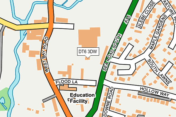
DT6 3DW is located in the Bridport electoral ward, within the unitary authority of Dorset and the English Parliamentary constituency of West Dorset. The Sub Integrated Care Board (ICB) Location is NHS Dorset ICB - 11J and the police force is Dorset. This postcode has been in use since January 1980.


GetTheData
Source: OS OpenMap – Local (Ordnance Survey)
Source: OS VectorMap District (Ordnance Survey)
Licence: Open Government Licence (requires attribution)
| Easting | 346716 |
| Northing | 92046 |
| Latitude | 50.725579 |
| Longitude | -2.756263 |
GetTheData
Source: Open Postcode Geo
Licence: Open Government Licence
| Country | England |
| Postcode District | DT6 |
➜ See where DT6 is on a map ➜ Where is Bridport? | |
GetTheData
Source: Land Registry Price Paid Data
Licence: Open Government Licence
Elevation or altitude of DT6 3DW as distance above sea level:
| Metres | Feet | |
|---|---|---|
| Elevation | 10m | 33ft |
Elevation is measured from the approximate centre of the postcode, to the nearest point on an OS contour line from OS Terrain 50, which has contour spacing of ten vertical metres.
➜ How high above sea level am I? Find the elevation of your current position using your device's GPS.
GetTheData
Source: Open Postcode Elevation
Licence: Open Government Licence
| Ward | Bridport |
| Constituency | West Dorset |
GetTheData
Source: ONS Postcode Database
Licence: Open Government Licence
| Hollow Way | Bothenhampton | 104m |
| Morrisons Car Park | Bridport | 104m |
| Hollow Way | Bothenhampton | 111m |
| Maple Gardens | Bothenhampton | 129m |
| Mountjoy School (West Bay Road) | Bridport | 147m |
GetTheData
Source: NaPTAN
Licence: Open Government Licence
GetTheData
Source: ONS Postcode Database
Licence: Open Government Licence


➜ Get more ratings from the Food Standards Agency
GetTheData
Source: Food Standards Agency
Licence: FSA terms & conditions
| Last Collection | |||
|---|---|---|---|
| Location | Mon-Fri | Sat | Distance |
| West Bay Road | 16:00 | 12:00 | 142m |
| Salway Ash P.o. | 16:00 | 11:30 | 213m |
| Valley Road | 16:00 | 12:00 | 439m |
GetTheData
Source: Dracos
Licence: Creative Commons Attribution-ShareAlike
| Risk of DT6 3DW flooding from rivers and sea | Low |
| ➜ DT6 3DW flood map | |
GetTheData
Source: Open Flood Risk by Postcode
Licence: Open Government Licence
The below table lists the International Territorial Level (ITL) codes (formerly Nomenclature of Territorial Units for Statistics (NUTS) codes) and Local Administrative Units (LAU) codes for DT6 3DW:
| ITL 1 Code | Name |
|---|---|
| TLK | South West (England) |
| ITL 2 Code | Name |
| TLK2 | Dorset and Somerset |
| ITL 3 Code | Name |
| TLK25 | Dorset |
| LAU 1 Code | Name |
| E06000059 | Dorset |
GetTheData
Source: ONS Postcode Directory
Licence: Open Government Licence
The below table lists the Census Output Area (OA), Lower Layer Super Output Area (LSOA), and Middle Layer Super Output Area (MSOA) for DT6 3DW:
| Code | Name | |
|---|---|---|
| OA | E00103956 | |
| LSOA | E01020504 | West Dorset 008C |
| MSOA | E02004276 | West Dorset 008 |
GetTheData
Source: ONS Postcode Directory
Licence: Open Government Licence
| DT6 3QG | Flood Lane | 96m |
| DT6 4DR | Maple Gardens | 145m |
| DT6 3QH | West Bay Road | 168m |
| DT6 4BE | Lansdowne Road | 179m |
| DT6 4BG | Lansdowne Road | 200m |
| DT6 3QQ | West Bay Road | 207m |
| DT6 4DT | Glebe Close | 230m |
| DT6 4DP | Maple Gardens | 238m |
| DT6 4DS | South Lawns | 251m |
| DT6 4BQ | Westown | 269m |
GetTheData
Source: Open Postcode Geo; Land Registry Price Paid Data
Licence: Open Government Licence