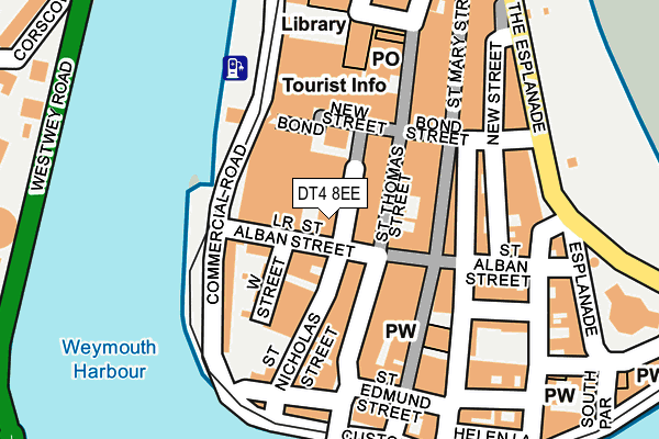
DT4 8EE is located in the Melcombe Regis electoral ward, within the unitary authority of Dorset and the English Parliamentary constituency of South Dorset. The Sub Integrated Care Board (ICB) Location is NHS Dorset ICB - 11J and the police force is Dorset. This postcode has been in use since January 1980.


GetTheData
Source: OS OpenMap – Local (Ordnance Survey)
Source: OS VectorMap District (Ordnance Survey)
Licence: Open Government Licence (requires attribution)
| Easting | 367864 |
| Northing | 78930 |
| Latitude | 50.609182 |
| Longitude | -2.455516 |
GetTheData
Source: Open Postcode Geo
Licence: Open Government Licence
| Country | England |
| Postcode District | DT4 |
| ➜ DT4 open data dashboard ➜ See where DT4 is on a map ➜ Where is Weymouth? | |
GetTheData
Source: Land Registry Price Paid Data
Licence: Open Government Licence
Elevation or altitude of DT4 8EE as distance above sea level:
| Metres | Feet | |
|---|---|---|
| Elevation | 10m | 33ft |
Elevation is measured from the approximate centre of the postcode, to the nearest point on an OS contour line from OS Terrain 50, which has contour spacing of ten vertical metres.
➜ How high above sea level am I? Find the elevation of your current position using your device's GPS.
GetTheData
Source: Open Postcode Elevation
Licence: Open Government Licence
| Ward | Melcombe Regis |
| Constituency | South Dorset |
GetTheData
Source: ONS Postcode Database
Licence: Open Government Licence
| January 2024 | Anti-social behaviour | On or near Parking Area | 72m |
| January 2024 | Anti-social behaviour | On or near Parking Area | 72m |
| January 2024 | Public order | On or near Parking Area | 72m |
| ➜ Get more crime data in our Crime section | |||
GetTheData
Source: data.police.uk
Licence: Open Government Licence
| Commercial Road | Weymouth | 95m |
| Commercial Road | Weymouth | 101m |
| Commercial Road | Weymouth | 143m |
| Town Bridge North (Lower St Edmund Street) | Weymouth | 149m |
| Town Bridge | Weymouth | 168m |
| Weymouth Station | 0.7km |
| Upwey Station | 4.4km |
GetTheData
Source: NaPTAN
Licence: Open Government Licence
GetTheData
Source: ONS Postcode Database
Licence: Open Government Licence


➜ Get more ratings from the Food Standards Agency
GetTheData
Source: Food Standards Agency
Licence: FSA terms & conditions
| Last Collection | |||
|---|---|---|---|
| Location | Mon-Fri | Sat | Distance |
| St Mary Street | 18:30 | 12:00 | 155m |
| Bond Street | 18:30 | 12:00 | 195m |
| Alexandra Gdns | 18:30 | 12:00 | 244m |
GetTheData
Source: Dracos
Licence: Creative Commons Attribution-ShareAlike
| Facility | Distance |
|---|---|
| Active Fitness Club (Weymouth) Newstead Road, Weymouth Health and Fitness Gym, Studio, Squash Courts | 398m |
| Moonfleet 2000 Indoor Bowls Club Knightsdale Road, Weymouth Indoor Bowls | 842m |
| The Marsh Playing Fields Knightsdale Road, Weymouth Athletics, Grass Pitches | 979m |
GetTheData
Source: Active Places
Licence: Open Government Licence
| School | Phase of Education | Distance |
|---|---|---|
| Beechcroft St Pauls CofE Primary School Corporation Road, Weymouth, DT4 0LQ | Primary | 1.1km |
| Holy Trinity Church of England VC Primary School & Community Nursery Cross Road, Weymouth, DT4 9QX | Primary | 1.2km |
| Arbour House School 15-17 Glendinning Avenue, Weymouth, Dorset, DT4 7QF | Not applicable | 1.3km |
GetTheData
Source: Edubase
Licence: Open Government Licence
The below table lists the International Territorial Level (ITL) codes (formerly Nomenclature of Territorial Units for Statistics (NUTS) codes) and Local Administrative Units (LAU) codes for DT4 8EE:
| ITL 1 Code | Name |
|---|---|
| TLK | South West (England) |
| ITL 2 Code | Name |
| TLK2 | Dorset and Somerset |
| ITL 3 Code | Name |
| TLK25 | Dorset |
| LAU 1 Code | Name |
| E06000059 | Dorset |
GetTheData
Source: ONS Postcode Directory
Licence: Open Government Licence
The below table lists the Census Output Area (OA), Lower Layer Super Output Area (LSOA), and Middle Layer Super Output Area (MSOA) for DT4 8EE:
| Code | Name | |
|---|---|---|
| OA | E00104265 | |
| LSOA | E01020554 | Weymouth and Portland 004B |
| MSOA | E02004284 | Weymouth and Portland 004 |
GetTheData
Source: ONS Postcode Directory
Licence: Open Government Licence
| DT4 8AU | Lower St Alban Street | 38m |
| DT4 8AT | West Street | 56m |
| DT4 8EL | St Thomas Street | 62m |
| DT4 8AF | Lower St Alban Street | 68m |
| DT4 8EJ | St Thomas Street | 68m |
| DT4 8AA | St Nicholas Street | 70m |
| DT4 8LY | New Bond Street | 78m |
| DT4 8AG | West Street | 82m |
| DT4 8PJ | St Mary Street | 91m |
| DT4 8EQ | St Thomas Street | 97m |
GetTheData
Source: Open Postcode Geo; Land Registry Price Paid Data
Licence: Open Government Licence