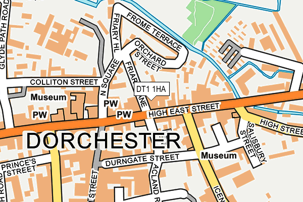
DT1 1HA is located in the Dorchester West electoral ward, within the unitary authority of Dorset and the English Parliamentary constituency of West Dorset. The Sub Integrated Care Board (ICB) Location is NHS Dorset ICB - 11J and the police force is Dorset. This postcode has been in use since January 1980.


GetTheData
Source: OS OpenMap – Local (Ordnance Survey)
Source: OS VectorMap District (Ordnance Survey)
Licence: Open Government Licence (requires attribution)
| Easting | 369358 |
| Northing | 90771 |
| Latitude | 50.715745 |
| Longitude | -2.435388 |
GetTheData
Source: Open Postcode Geo
Licence: Open Government Licence
| Country | England |
| Postcode District | DT1 |
| ➜ DT1 open data dashboard ➜ See where DT1 is on a map ➜ Where is Dorchester? | |
GetTheData
Source: Land Registry Price Paid Data
Licence: Open Government Licence
Elevation or altitude of DT1 1HA as distance above sea level:
| Metres | Feet | |
|---|---|---|
| Elevation | 60m | 197ft |
Elevation is measured from the approximate centre of the postcode, to the nearest point on an OS contour line from OS Terrain 50, which has contour spacing of ten vertical metres.
➜ How high above sea level am I? Find the elevation of your current position using your device's GPS.
GetTheData
Source: Open Postcode Elevation
Licence: Open Government Licence
| Ward | Dorchester West |
| Constituency | West Dorset |
GetTheData
Source: ONS Postcode Database
Licence: Open Government Licence
| January 2024 | Violence and sexual offences | On or near Petrol Station | 356m |
| November 2023 | Other theft | On or near Petrol Station | 356m |
| November 2023 | Shoplifting | On or near Petrol Station | 356m |
| ➜ Get more crime data in our Crime section | |||
GetTheData
Source: data.police.uk
Licence: Open Government Licence
| The Museum (High West Street) | Dorchester | 140m |
| Acland Road | Dorchester | 259m |
| Trinity Street | Dorchester | 309m |
| County Hall Main Entrance (Colliton Park) | Dorchester | 330m |
| Top O Town (High West Street) | Dorchester | 385m |
| Dorchester South Station | 0.7km |
| Dorchester West Station | 0.7km |
GetTheData
Source: NaPTAN
Licence: Open Government Licence
GetTheData
Source: ONS Postcode Database
Licence: Open Government Licence

➜ Get more ratings from the Food Standards Agency
GetTheData
Source: Food Standards Agency
Licence: FSA terms & conditions
| Last Collection | |||
|---|---|---|---|
| Location | Mon-Fri | Sat | Distance |
| Museum | 17:30 | 11:30 | 170m |
| White Hart | 16:00 | 11:30 | 178m |
| Trinity Street | 17:30 | 13:00 | 336m |
GetTheData
Source: Dracos
Licence: Creative Commons Attribution-ShareAlike
| Facility | Distance |
|---|---|
| The Gym Group (Dorchester) Trinity Street, Dorchester Health and Fitness Gym | 359m |
| Dorchester Health Club (Closed) Somerleigh Road, Dorchester Health and Fitness Gym, Studio | 393m |
| Sunninghill Preparatory School South Walks Road, Dorchester Grass Pitches, Swimming Pool, Outdoor Tennis Courts | 433m |
GetTheData
Source: Active Places
Licence: Open Government Licence
| School | Phase of Education | Distance |
|---|---|---|
| Sunninghill Preparatory School South Court, South Walks, Dorchester, DT1 1EB | Not applicable | 439m |
| St Mary's Catholic First School, Dorchester Lucetta Lane, Dorchester, DT1 2DD | Primary | 921m |
| St Osmund's Church of England Middle School Barnes Way, Dorchester, DT1 2DZ | Middle deemed secondary | 1.2km |
GetTheData
Source: Edubase
Licence: Open Government Licence
The below table lists the International Territorial Level (ITL) codes (formerly Nomenclature of Territorial Units for Statistics (NUTS) codes) and Local Administrative Units (LAU) codes for DT1 1HA:
| ITL 1 Code | Name |
|---|---|
| TLK | South West (England) |
| ITL 2 Code | Name |
| TLK2 | Dorset and Somerset |
| ITL 3 Code | Name |
| TLK25 | Dorset |
| LAU 1 Code | Name |
| E06000059 | Dorset |
GetTheData
Source: ONS Postcode Directory
Licence: Open Government Licence
The below table lists the Census Output Area (OA), Lower Layer Super Output Area (LSOA), and Middle Layer Super Output Area (MSOA) for DT1 1HA:
| Code | Name | |
|---|---|---|
| OA | E00104070 | |
| LSOA | E01032644 | West Dorset 009H |
| MSOA | E02004277 | West Dorset 009 |
GetTheData
Source: ONS Postcode Directory
Licence: Open Government Licence
| DT1 1HF | High East Street | 37m |
| DT1 1JN | Church Street | 46m |
| DT1 1HN | High East Street | 52m |
| DT1 1HH | High East Street | 57m |
| DT1 1JR | Church Close | 69m |
| DT1 1JJ | Friary Lane | 73m |
| DT1 1EZ | High East Street | 78m |
| DT1 1NB | Church Street | 86m |
| DT1 1HY | North Square | 91m |
| DT1 1HR | High East Street | 92m |
GetTheData
Source: Open Postcode Geo; Land Registry Price Paid Data
Licence: Open Government Licence