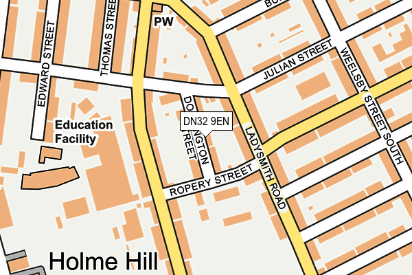
DN32 9EN lies on Donnington Street in Grimsby. DN32 9EN is located in the Heneage electoral ward, within the unitary authority of North East Lincolnshire and the English Parliamentary constituency of Great Grimsby. The Sub Integrated Care Board (ICB) Location is NHS Humber and North Yorkshire ICB - 03H and the police force is Humberside. This postcode has been in use since January 1980.


GetTheData
Source: OS OpenMap – Local (Ordnance Survey)
Source: OS VectorMap District (Ordnance Survey)
Licence: Open Government Licence (requires attribution)
| Easting | 527941 |
| Northing | 409113 |
| Latitude | 53.563042 |
| Longitude | -0.069772 |
GetTheData
Source: Open Postcode Geo
Licence: Open Government Licence
| Street | Donnington Street |
| Town/City | Grimsby |
| Country | England |
| Postcode District | DN32 |
➜ See where DN32 is on a map ➜ Where is Grimsby? | |
GetTheData
Source: Land Registry Price Paid Data
Licence: Open Government Licence
Elevation or altitude of DN32 9EN as distance above sea level:
| Metres | Feet | |
|---|---|---|
| Elevation | 10m | 33ft |
Elevation is measured from the approximate centre of the postcode, to the nearest point on an OS contour line from OS Terrain 50, which has contour spacing of ten vertical metres.
➜ How high above sea level am I? Find the elevation of your current position using your device's GPS.
GetTheData
Source: Open Postcode Elevation
Licence: Open Government Licence
| Ward | Heneage |
| Constituency | Great Grimsby |
GetTheData
Source: ONS Postcode Database
Licence: Open Government Licence
| Julian Street (Ladysmith Road) | Weelsby | 70m |
| Durban Road | Weelsby | 99m |
| Durban Road | Weelsby | 124m |
| Weelsby Street South (Durban Road) | Weelsby | 205m |
| Columbia Road (Ladysmith Road) | Weelsby | 249m |
| Grimsby Town Station | 1.1km |
| Grimsby Docks Station | 1.3km |
| New Clee Station | 1.4km |
GetTheData
Source: NaPTAN
Licence: Open Government Licence
| Percentage of properties with Next Generation Access | 100.0% |
| Percentage of properties with Superfast Broadband | 100.0% |
| Percentage of properties with Ultrafast Broadband | 98.0% |
| Percentage of properties with Full Fibre Broadband | 0.0% |
Superfast Broadband is between 30Mbps and 300Mbps
Ultrafast Broadband is > 300Mbps
| Median download speed | 100.0Mbps |
| Average download speed | 117.2Mbps |
| Maximum download speed | 350.00Mbps |
| Median upload speed | 19.0Mbps |
| Average upload speed | 11.7Mbps |
| Maximum upload speed | 20.00Mbps |
| Percentage of properties unable to receive 2Mbps | 0.0% |
| Percentage of properties unable to receive 5Mbps | 0.0% |
| Percentage of properties unable to receive 10Mbps | 0.0% |
| Percentage of properties unable to receive 30Mbps | 0.0% |
GetTheData
Source: Ofcom
Licence: Ofcom Terms of Use (requires attribution)
Estimated total energy consumption in DN32 9EN by fuel type, 2015.
| Consumption (kWh) | 455,725 |
|---|---|
| Meter count | 57 |
| Mean (kWh/meter) | 7,995 |
| Median (kWh/meter) | 6,931 |
| Consumption (kWh) | 167,299 |
|---|---|
| Meter count | 52 |
| Mean (kWh/meter) | 3,217 |
| Median (kWh/meter) | 3,043 |
GetTheData
Source: Postcode level gas estimates: 2015 (experimental)
Source: Postcode level electricity estimates: 2015 (experimental)
Licence: Open Government Licence
GetTheData
Source: ONS Postcode Database
Licence: Open Government Licence


➜ Get more ratings from the Food Standards Agency
GetTheData
Source: Food Standards Agency
Licence: FSA terms & conditions
| Last Collection | |||
|---|---|---|---|
| Location | Mon-Fri | Sat | Distance |
| Convamore Road | 17:30 | 11:00 | 157m |
| Buller Street | 17:30 | 11:00 | 231m |
| Legsby Avenue | 17:30 | 10:30 | 384m |
GetTheData
Source: Dracos
Licence: Creative Commons Attribution-ShareAlike
| Risk of DN32 9EN flooding from rivers and sea | Low |
| ➜ DN32 9EN flood map | |
GetTheData
Source: Open Flood Risk by Postcode
Licence: Open Government Licence
The below table lists the International Territorial Level (ITL) codes (formerly Nomenclature of Territorial Units for Statistics (NUTS) codes) and Local Administrative Units (LAU) codes for DN32 9EN:
| ITL 1 Code | Name |
|---|---|
| TLE | Yorkshire and The Humber |
| ITL 2 Code | Name |
| TLE1 | East Yorkshire and Northern Lincolnshire |
| ITL 3 Code | Name |
| TLE13 | North and North East Lincolnshire |
| LAU 1 Code | Name |
| E06000012 | North East Lincolnshire |
GetTheData
Source: ONS Postcode Directory
Licence: Open Government Licence
The below table lists the Census Output Area (OA), Lower Layer Super Output Area (LSOA), and Middle Layer Super Output Area (MSOA) for DN32 9EN:
| Code | Name | |
|---|---|---|
| OA | E00066402 | |
| LSOA | E01013159 | North East Lincolnshire 011A |
| MSOA | E02002736 | North East Lincolnshire 011 |
GetTheData
Source: ONS Postcode Directory
Licence: Open Government Licence
| DN32 9EG | Ladysmith Road | 46m |
| DN32 9HU | Convamore Road | 76m |
| DN32 9HT | Sixhills Street | 85m |
| DN32 9EJ | Ropery Street | 88m |
| DN32 9HS | Sixhills Street | 94m |
| DN32 9HX | Convamore Road | 106m |
| DN32 9EF | Ladysmith Road | 122m |
| DN32 8BG | Julian Street | 146m |
| DN32 9HR | Convamore Road | 151m |
| DN32 9EQ | Ladysmith Road | 152m |
GetTheData
Source: Open Postcode Geo; Land Registry Price Paid Data
Licence: Open Government Licence