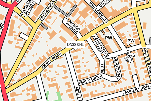
DN32 0HL is located in the Park electoral ward, within the unitary authority of North East Lincolnshire and the English Parliamentary constituency of Great Grimsby. The Sub Integrated Care Board (ICB) Location is NHS Humber and North Yorkshire ICB - 03H and the police force is Humberside. This postcode has been in use since January 1980.


GetTheData
Source: OS OpenMap – Local (Ordnance Survey)
Source: OS VectorMap District (Ordnance Survey)
Licence: Open Government Licence (requires attribution)
| Easting | 526754 |
| Northing | 408820 |
| Latitude | 53.560698 |
| Longitude | -0.087802 |
GetTheData
Source: Open Postcode Geo
Licence: Open Government Licence
| Country | England |
| Postcode District | DN32 |
➜ See where DN32 is on a map ➜ Where is Grimsby? | |
GetTheData
Source: Land Registry Price Paid Data
Licence: Open Government Licence
Elevation or altitude of DN32 0HL as distance above sea level:
| Metres | Feet | |
|---|---|---|
| Elevation | 10m | 33ft |
Elevation is measured from the approximate centre of the postcode, to the nearest point on an OS contour line from OS Terrain 50, which has contour spacing of ten vertical metres.
➜ How high above sea level am I? Find the elevation of your current position using your device's GPS.
GetTheData
Source: Open Postcode Elevation
Licence: Open Government Licence
| Ward | Park |
| Constituency | Great Grimsby |
GetTheData
Source: ONS Postcode Database
Licence: Open Government Licence
| Pelham Road (Bargate) | Bargate | 288m |
| Pelham Road (Bargate) | Bargate | 304m |
| Cartergate (Dudley Street) | West Marsh | 338m |
| Abbey Road (Bargate) | Bargate | 342m |
| Abbey Road (Bargate) | Bargate | 348m |
| Grimsby Town Station | 0.3km |
| Grimsby Docks Station | 1.7km |
| New Clee Station | 2.3km |
GetTheData
Source: NaPTAN
Licence: Open Government Licence
GetTheData
Source: ONS Postcode Database
Licence: Open Government Licence


➜ Get more ratings from the Food Standards Agency
GetTheData
Source: Food Standards Agency
Licence: FSA terms & conditions
| Last Collection | |||
|---|---|---|---|
| Location | Mon-Fri | Sat | Distance |
| Abbey Park Road | 17:30 | 12:15 | 126m |
| Wellowgate | 17:30 | 12:15 | 158m |
| Bargate Avenue | 17:30 | 10:45 | 208m |
GetTheData
Source: Dracos
Licence: Creative Commons Attribution-ShareAlike
| Risk of DN32 0HL flooding from rivers and sea | Very Low |
| ➜ DN32 0HL flood map | |
GetTheData
Source: Open Flood Risk by Postcode
Licence: Open Government Licence
The below table lists the International Territorial Level (ITL) codes (formerly Nomenclature of Territorial Units for Statistics (NUTS) codes) and Local Administrative Units (LAU) codes for DN32 0HL:
| ITL 1 Code | Name |
|---|---|
| TLE | Yorkshire and The Humber |
| ITL 2 Code | Name |
| TLE1 | East Yorkshire and Northern Lincolnshire |
| ITL 3 Code | Name |
| TLE13 | North and North East Lincolnshire |
| LAU 1 Code | Name |
| E06000012 | North East Lincolnshire |
GetTheData
Source: ONS Postcode Directory
Licence: Open Government Licence
The below table lists the Census Output Area (OA), Lower Layer Super Output Area (LSOA), and Middle Layer Super Output Area (MSOA) for DN32 0HL:
| Code | Name | |
|---|---|---|
| OA | E00066515 | |
| LSOA | E01013184 | North East Lincolnshire 016D |
| MSOA | E02002741 | North East Lincolnshire 016 |
GetTheData
Source: ONS Postcode Directory
Licence: Open Government Licence
| DN32 0HJ | Abbey Park Road | 67m |
| DN32 0HQ | Abbey Road | 92m |
| DN32 0HH | Abbey Drive West | 106m |
| DN32 0QR | Manor Avenue | 109m |
| DN32 0HD | Abbey Drive East | 126m |
| DN32 0HR | Abbey Park Road | 131m |
| DN32 0JA | Abbey Park Mews | 142m |
| DN32 0HF | Abbey Road | 145m |
| DN32 0HN | Abbey Road | 151m |
| DN32 0HB | Abbotsway | 176m |
GetTheData
Source: Open Postcode Geo; Land Registry Price Paid Data
Licence: Open Government Licence