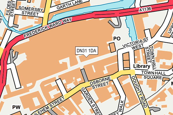
DN31 1DA is located in the West Marsh electoral ward, within the unitary authority of North East Lincolnshire and the English Parliamentary constituency of Great Grimsby. The Sub Integrated Care Board (ICB) Location is NHS Humber and North Yorkshire ICB - 03H and the police force is Humberside. This postcode has been in use since January 1980.


GetTheData
Source: OS OpenMap – Local (Ordnance Survey)
Source: OS VectorMap District (Ordnance Survey)
Licence: Open Government Licence (requires attribution)
| Easting | 526885 |
| Northing | 409370 |
| Latitude | 53.565607 |
| Longitude | -0.085602 |
GetTheData
Source: Open Postcode Geo
Licence: Open Government Licence
| Country | England |
| Postcode District | DN31 |
| ➜ DN31 open data dashboard ➜ See where DN31 is on a map ➜ Where is Grimsby? | |
GetTheData
Source: Land Registry Price Paid Data
Licence: Open Government Licence
Elevation or altitude of DN31 1DA as distance above sea level:
| Metres | Feet | |
|---|---|---|
| Elevation | 10m | 33ft |
Elevation is measured from the approximate centre of the postcode, to the nearest point on an OS contour line from OS Terrain 50, which has contour spacing of ten vertical metres.
➜ How high above sea level am I? Find the elevation of your current position using your device's GPS.
GetTheData
Source: Open Postcode Elevation
Licence: Open Government Licence
| Ward | West Marsh |
| Constituency | Great Grimsby |
GetTheData
Source: ONS Postcode Database
Licence: Open Government Licence
| January 2024 | Public order | On or near Parking Area | 195m |
| January 2024 | Anti-social behaviour | On or near Parking Area | 225m |
| January 2024 | Violence and sexual offences | On or near South Parade | 320m |
| ➜ Get more crime data in our Crime section | |||
GetTheData
Source: data.police.uk
Licence: Open Government Licence
| Yarborough Hotel (Bethlehem Street) | Grimsby | 177m |
| Registry Office (Town Hall Square) | Grimsby | 188m |
| Registry Office (Town Hall Square) | Grimsby | 198m |
| Old Market Place (Bethlehem Street) | Grimsby | 233m |
| St James Church Stop 1 (Bethlehem Street) | Grimsby | 247m |
| Grimsby Town Station | 0.3km |
| Grimsby Docks Station | 1.2km |
| New Clee Station | 1.9km |
GetTheData
Source: NaPTAN
Licence: Open Government Licence
GetTheData
Source: ONS Postcode Database
Licence: Open Government Licence


➜ Get more ratings from the Food Standards Agency
GetTheData
Source: Food Standards Agency
Licence: FSA terms & conditions
| Last Collection | |||
|---|---|---|---|
| Location | Mon-Fri | Sat | Distance |
| Abbey Walk | 18:30 | 13:15 | 139m |
| Railway Station | 18:00 | 10:30 | 233m |
| Earl Street | 16:00 | 11:00 | 439m |
GetTheData
Source: Dracos
Licence: Creative Commons Attribution-ShareAlike
| Facility | Distance |
|---|---|
| Puregym (Grimsby) Riverhead, Grimsby Health and Fitness Gym, Studio | 216m |
| Ormiston South Parade Primary Academy South Parade, Grimsby Grass Pitches | 336m |
| Reshapers Health And Fitness Bowling Green Lane, Grimsby Health and Fitness Gym, Studio | 467m |
GetTheData
Source: Active Places
Licence: Open Government Licence
| School | Phase of Education | Distance |
|---|---|---|
| Ormiston South Parade Academy South Parade, Grimsby, DN31 1TU | Primary | 293m |
| St James' School 22 Bargate, Grimsby, DN34 4SY | Not applicable | 738m |
| Edward Heneage Primary Academy Edward Street, Grimsby, DN32 9HL | Primary | 829m |
GetTheData
Source: Edubase
Licence: Open Government Licence
The below table lists the International Territorial Level (ITL) codes (formerly Nomenclature of Territorial Units for Statistics (NUTS) codes) and Local Administrative Units (LAU) codes for DN31 1DA:
| ITL 1 Code | Name |
|---|---|
| TLE | Yorkshire and The Humber |
| ITL 2 Code | Name |
| TLE1 | East Yorkshire and Northern Lincolnshire |
| ITL 3 Code | Name |
| TLE13 | North and North East Lincolnshire |
| LAU 1 Code | Name |
| E06000012 | North East Lincolnshire |
GetTheData
Source: ONS Postcode Directory
Licence: Open Government Licence
The below table lists the Census Output Area (OA), Lower Layer Super Output Area (LSOA), and Middle Layer Super Output Area (MSOA) for DN31 1DA:
| Code | Name | |
|---|---|---|
| OA | E00066710 | |
| LSOA | E01013221 | North East Lincolnshire 003D |
| MSOA | E02002728 | North East Lincolnshire 003 |
GetTheData
Source: ONS Postcode Directory
Licence: Open Government Licence
| DN31 1BL | Victoria Street | 67m |
| DN31 1LW | South St Marys Gate | 80m |
| DN31 1LQ | South St Marys Gate | 98m |
| DN31 1LB | West St Marys Gate | 123m |
| DN31 1NB | Abbey Walk | 154m |
| DN31 1HH | New Street | 166m |
| DN31 1BA | Victoria Street | 184m |
| DN31 1NA | Garden Street | 186m |
| DN31 1DT | Old Market Place | 190m |
| DN31 1HN | Town Hall Street | 206m |
GetTheData
Source: Open Postcode Geo; Land Registry Price Paid Data
Licence: Open Government Licence