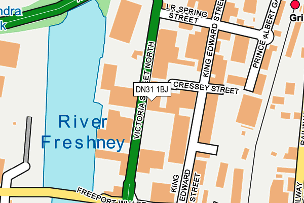
DN31 1BJ is located in the West Marsh electoral ward, within the unitary authority of North East Lincolnshire and the English Parliamentary constituency of Great Grimsby. The Sub Integrated Care Board (ICB) Location is NHS Humber and North Yorkshire ICB - 03H and the police force is Humberside. This postcode has been in use since January 1980.


GetTheData
Source: OS OpenMap – Local (Ordnance Survey)
Source: OS VectorMap District (Ordnance Survey)
Licence: Open Government Licence (requires attribution)
| Easting | 527217 |
| Northing | 410131 |
| Latitude | 53.572363 |
| Longitude | -0.080282 |
GetTheData
Source: Open Postcode Geo
Licence: Open Government Licence
| Country | England |
| Postcode District | DN31 |
➜ See where DN31 is on a map ➜ Where is Grimsby? | |
GetTheData
Source: Land Registry Price Paid Data
Licence: Open Government Licence
Elevation or altitude of DN31 1BJ as distance above sea level:
| Metres | Feet | |
|---|---|---|
| Elevation | 10m | 33ft |
Elevation is measured from the approximate centre of the postcode, to the nearest point on an OS contour line from OS Terrain 50, which has contour spacing of ten vertical metres.
➜ How high above sea level am I? Find the elevation of your current position using your device's GPS.
GetTheData
Source: Open Postcode Elevation
Licence: Open Government Licence
| Ward | West Marsh |
| Constituency | Great Grimsby |
GetTheData
Source: ONS Postcode Database
Licence: Open Government Licence
| Lower Spring Street (Victoria Street North) | Grimsby | 119m |
| Lower Spring Street (Victoria Street North) | Grimsby | 156m |
| Victoria Retail Park (Victoria Street South) | Grimsby | 240m |
| Corporation Bridge (Corporation Road) | Grimsby | 293m |
| Corporation Bridge (Corporation Road) | Grimsby | 305m |
| Grimsby Docks Station | 0.4km |
| Grimsby Town Station | 1.1km |
| New Clee Station | 1.3km |
GetTheData
Source: NaPTAN
Licence: Open Government Licence
GetTheData
Source: ONS Postcode Database
Licence: Open Government Licence
➜ Get more ratings from the Food Standards Agency
GetTheData
Source: Food Standards Agency
Licence: FSA terms & conditions
| Last Collection | |||
|---|---|---|---|
| Location | Mon-Fri | Sat | Distance |
| Albert Street | 18:30 | 11:45 | 446m |
| Dunconbe Street | 18:30 | 11:45 | 495m |
| Freeman Street | 18:30 | 12:30 | 635m |
GetTheData
Source: Dracos
Licence: Creative Commons Attribution-ShareAlike
| Risk of DN31 1BJ flooding from rivers and sea | Very Low |
| ➜ DN31 1BJ flood map | |
GetTheData
Source: Open Flood Risk by Postcode
Licence: Open Government Licence
The below table lists the International Territorial Level (ITL) codes (formerly Nomenclature of Territorial Units for Statistics (NUTS) codes) and Local Administrative Units (LAU) codes for DN31 1BJ:
| ITL 1 Code | Name |
|---|---|
| TLE | Yorkshire and The Humber |
| ITL 2 Code | Name |
| TLE1 | East Yorkshire and Northern Lincolnshire |
| ITL 3 Code | Name |
| TLE13 | North and North East Lincolnshire |
| LAU 1 Code | Name |
| E06000012 | North East Lincolnshire |
GetTheData
Source: ONS Postcode Directory
Licence: Open Government Licence
The below table lists the Census Output Area (OA), Lower Layer Super Output Area (LSOA), and Middle Layer Super Output Area (MSOA) for DN31 1BJ:
| Code | Name | |
|---|---|---|
| OA | E00066689 | |
| LSOA | E01013221 | North East Lincolnshire 003D |
| MSOA | E02002728 | North East Lincolnshire 003 |
GetTheData
Source: ONS Postcode Directory
Licence: Open Government Licence
| DN31 1PQ | Victoria Wharf | 140m |
| DN31 1PT | Victoria Street | 145m |
| DN31 3JP | King Edward Street | 152m |
| DN31 3JS | Lower Spring Street | 190m |
| DN31 3LA | King Edward Street | 200m |
| DN32 7BN | Railway Street | 320m |
| DN31 3AG | Prince Albert Gardens | 323m |
| DN31 3LB | Cleethorpe Road | 326m |
| DN32 7SL | Albert Street West | 332m |
| DN32 7SQ | Duncombe Gardens | 377m |
GetTheData
Source: Open Postcode Geo; Land Registry Price Paid Data
Licence: Open Government Licence