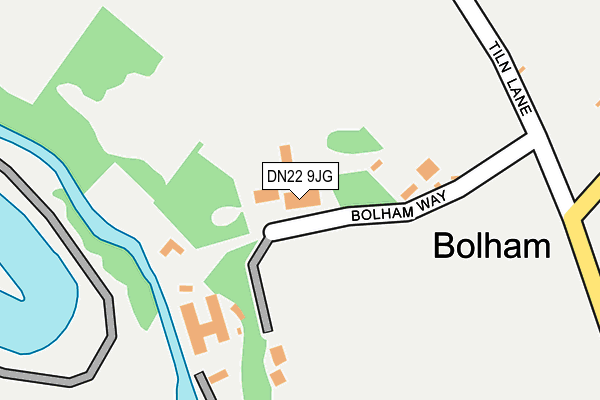
DN22 9JG lies on Bolham Villas in Bolham, Retford. DN22 9JG is located in the East Retford North electoral ward, within the local authority district of Bassetlaw and the English Parliamentary constituency of Bassetlaw. The Sub Integrated Care Board (ICB) Location is NHS Nottingham and Nottinghamshire ICB - 02Q and the police force is Nottinghamshire. This postcode has been in use since January 1980.


GetTheData
Source: OS OpenMap – Local (Ordnance Survey)
Source: OS VectorMap District (Ordnance Survey)
Licence: Open Government Licence (requires attribution)
| Easting | 470573 |
| Northing | 382701 |
| Latitude | 53.336539 |
| Longitude | -0.941621 |
GetTheData
Source: Open Postcode Geo
Licence: Open Government Licence
| Street | Bolham Villas |
| Locality | Bolham |
| Town/City | Retford |
| Country | England |
| Postcode District | DN22 |
| ➜ DN22 open data dashboard ➜ See where DN22 is on a map ➜ Where is Bolham? | |
GetTheData
Source: Land Registry Price Paid Data
Licence: Open Government Licence
Elevation or altitude of DN22 9JG as distance above sea level:
| Metres | Feet | |
|---|---|---|
| Elevation | 20m | 66ft |
Elevation is measured from the approximate centre of the postcode, to the nearest point on an OS contour line from OS Terrain 50, which has contour spacing of ten vertical metres.
➜ How high above sea level am I? Find the elevation of your current position using your device's GPS.
GetTheData
Source: Open Postcode Elevation
Licence: Open Government Licence
| Ward | East Retford North |
| Constituency | Bassetlaw |
GetTheData
Source: ONS Postcode Database
Licence: Open Government Licence
| April 2022 | Other theft | On or near Sports/Recreation Area | 182m |
| March 2022 | Violence and sexual offences | On or near Badgers Chase | 479m |
| February 2022 | Other theft | On or near Sports/Recreation Area | 182m |
| ➜ Get more crime data in our Crime section | |||
GetTheData
Source: data.police.uk
Licence: Open Government Licence
| Willand Court (Camborne Crescent) | Hallcroft | 654m |
| Richmond Road (Tiln Lane) | Retford | 730m |
| Cornwall Road | Retford | 781m |
| Elizabethan School (Bus Park) | Hallcroft | 808m |
| Heathfield Gardens (Woodbeck Rise) | Hallcroft | 845m |
| Retford Station | 2.4km |
| Retford Low Level Station | 2.5km |
GetTheData
Source: NaPTAN
Licence: Open Government Licence
| Percentage of properties with Next Generation Access | 100.0% |
| Percentage of properties with Superfast Broadband | 100.0% |
| Percentage of properties with Ultrafast Broadband | 0.0% |
| Percentage of properties with Full Fibre Broadband | 0.0% |
Superfast Broadband is between 30Mbps and 300Mbps
Ultrafast Broadband is > 300Mbps
| Percentage of properties unable to receive 2Mbps | 0.0% |
| Percentage of properties unable to receive 5Mbps | 0.0% |
| Percentage of properties unable to receive 10Mbps | 0.0% |
| Percentage of properties unable to receive 30Mbps | 0.0% |
GetTheData
Source: Ofcom
Licence: Ofcom Terms of Use (requires attribution)
GetTheData
Source: ONS Postcode Database
Licence: Open Government Licence


➜ Get more ratings from the Food Standards Agency
GetTheData
Source: Food Standards Agency
Licence: FSA terms & conditions
| Last Collection | |||
|---|---|---|---|
| Location | Mon-Fri | Sat | Distance |
| Tiln Lane | 17:30 | 11:45 | 641m |
| Hallcroft Road | 17:15 | 12:00 | 931m |
| Northfield Way | 17:15 | 12:00 | 1,153m |
GetTheData
Source: Dracos
Licence: Creative Commons Attribution-ShareAlike
| Facility | Distance |
|---|---|
| Tiln Lane Sports Ground Bolham Way, Bolham, Retford Grass Pitches | 184m |
| The Elizabethan Academy Hallcroft Road, Retford Sports Hall, Artificial Grass Pitch, Grass Pitches | 662m |
| Retford Cricket Club Cricket Field Lane, Retford Grass Pitches | 1.2km |
GetTheData
Source: Active Places
Licence: Open Government Licence
| School | Phase of Education | Distance |
|---|---|---|
| Carr Hill Primary and Nursery School Tiln Lane, Retford, DN22 6SW | Primary | 675m |
| The Elizabethan Academy Hallcroft Road, Retford, DN22 7PY | Secondary | 887m |
| Hallcroft Infant and Nursery School Whitaker Close, Retford, DN22 7QH | Primary | 1.3km |
GetTheData
Source: Edubase
Licence: Open Government Licence
The below table lists the International Territorial Level (ITL) codes (formerly Nomenclature of Territorial Units for Statistics (NUTS) codes) and Local Administrative Units (LAU) codes for DN22 9JG:
| ITL 1 Code | Name |
|---|---|
| TLF | East Midlands (England) |
| ITL 2 Code | Name |
| TLF1 | Derbyshire and Nottinghamshire |
| ITL 3 Code | Name |
| TLF15 | North Nottinghamshire |
| LAU 1 Code | Name |
| E07000171 | Bassetlaw |
GetTheData
Source: ONS Postcode Directory
Licence: Open Government Licence
The below table lists the Census Output Area (OA), Lower Layer Super Output Area (LSOA), and Middle Layer Super Output Area (MSOA) for DN22 9JG:
| Code | Name | |
|---|---|---|
| OA | E00142740 | |
| LSOA | E01028015 | Bassetlaw 005C |
| MSOA | E02005839 | Bassetlaw 005 |
GetTheData
Source: ONS Postcode Directory
Licence: Open Government Licence
| DN22 9JJ | Smeath Road | 331m |
| DN22 9JQ | 386m | |
| DN22 6SY | Bolham Lane | 471m |
| DN22 6RX | Badgers Chase | 472m |
| DN22 7SP | Fallow Close | 535m |
| DN22 6TA | Carr Hill Way | 539m |
| DN22 6SP | Tiln Lane | 545m |
| DN22 6TF | Idle View | 549m |
| DN22 7FP | Bovington Court | 554m |
| DN22 6TD | Tiln Court | 564m |
GetTheData
Source: Open Postcode Geo; Land Registry Price Paid Data
Licence: Open Government Licence