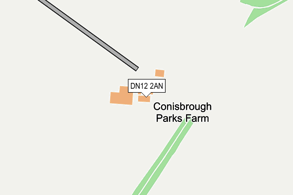
DN12 2AN is located in the Conisbrough electoral ward, within the metropolitan district of Doncaster and the English Parliamentary constituency of Don Valley. The Sub Integrated Care Board (ICB) Location is NHS South Yorkshire ICB - 02X and the police force is South Yorkshire. This postcode has been in use since January 1980.


GetTheData
Source: OS OpenMap – Local (Ordnance Survey)
Source: OS VectorMap District (Ordnance Survey)
Licence: Open Government Licence (requires attribution)
| Easting | 451263 |
| Northing | 396678 |
| Latitude | 53.464378 |
| Longitude | -1.229314 |
GetTheData
Source: Open Postcode Geo
Licence: Open Government Licence
| Country | England |
| Postcode District | DN12 |
| ➜ DN12 open data dashboard ➜ See where DN12 is on a map | |
GetTheData
Source: Land Registry Price Paid Data
Licence: Open Government Licence
Elevation or altitude of DN12 2AN as distance above sea level:
| Metres | Feet | |
|---|---|---|
| Elevation | 80m | 262ft |
Elevation is measured from the approximate centre of the postcode, to the nearest point on an OS contour line from OS Terrain 50, which has contour spacing of ten vertical metres.
➜ How high above sea level am I? Find the elevation of your current position using your device's GPS.
GetTheData
Source: Open Postcode Elevation
Licence: Open Government Licence
| Ward | Conisbrough |
| Constituency | Don Valley |
GetTheData
Source: ONS Postcode Database
Licence: Open Government Licence
| Common Lane (Beacon Lane) | Clifton | 839m |
| Beacon Lane | Clifton | 853m |
| Clifton Hill (Windmill Avenue) | Conisbrough | 1,541m |
| Pine Grove (Micklebring Grove) | Conisbrough | 1,617m |
| Maple Grove (Micklebring Grove) | Conisbrough | 1,642m |
| Conisbrough Station | 2.8km |
| Mexborough Station | 4.9km |
GetTheData
Source: NaPTAN
Licence: Open Government Licence
GetTheData
Source: ONS Postcode Database
Licence: Open Government Licence


➜ Get more ratings from the Food Standards Agency
GetTheData
Source: Food Standards Agency
Licence: FSA terms & conditions
| Last Collection | |||
|---|---|---|---|
| Location | Mon-Fri | Sat | Distance |
| Common Lane | 16:30 | 11:15 | 808m |
| Poplar Grove | 16:00 | 09:00 | 1,408m |
| Chestnut Grove | 16:00 | 09:00 | 1,672m |
GetTheData
Source: Dracos
Licence: Creative Commons Attribution-ShareAlike
| Facility | Distance |
|---|---|
| Crookhill Park Golf Course Carr Lane, Conisbrough, Doncaster Golf | 1.4km |
| Conisborough Cricket Club St Peters Drive, Conisbrough, Doncaster Grass Pitches | 1.5km |
| Conisbrough Ivanhoe Primary Academy Old Road, Old Road, Conisbrough, Doncaster Grass Pitches | 1.9km |
GetTheData
Source: Active Places
Licence: Open Government Licence
| School | Phase of Education | Distance |
|---|---|---|
| Conisbrough Ivanhoe Primary Academy Old Road, Conisbrough, Doncaster, DN12 3LR | Primary | 1.9km |
| Pennine View School Old Road, Conisbrough, Doncaster, DN12 3LR | Not applicable | 1.9km |
| Morley Place Academy Old Road, Conisbrough, Doncaster, DN12 3LZ | Primary | 2km |
GetTheData
Source: Edubase
Licence: Open Government Licence
The below table lists the International Territorial Level (ITL) codes (formerly Nomenclature of Territorial Units for Statistics (NUTS) codes) and Local Administrative Units (LAU) codes for DN12 2AN:
| ITL 1 Code | Name |
|---|---|
| TLE | Yorkshire and The Humber |
| ITL 2 Code | Name |
| TLE3 | South Yorkshire |
| ITL 3 Code | Name |
| TLE31 | Barnsley, Doncaster and Rotherham |
| LAU 1 Code | Name |
| E08000017 | Doncaster |
GetTheData
Source: ONS Postcode Directory
Licence: Open Government Licence
The below table lists the Census Output Area (OA), Lower Layer Super Output Area (LSOA), and Middle Layer Super Output Area (MSOA) for DN12 2AN:
| Code | Name | |
|---|---|---|
| OA | E00038570 | |
| LSOA | E01007613 | Doncaster 033D |
| MSOA | E02001571 | Doncaster 033 |
GetTheData
Source: ONS Postcode Directory
Licence: Open Government Licence
| S66 7RX | Common Lane | 694m |
| S66 7RS | Clifton Byres | 708m |
| S66 7SB | Church Lane | 732m |
| S66 7RY | Post Office Row | 749m |
| S66 7SL | Beech House Croft | 761m |
| S66 7RA | Back Lane | 800m |
| S66 7SF | Back Lane | 810m |
| S66 7RZ | Beacon Square | 855m |
| S66 7SA | Beacon Lane | 858m |
| DN12 2AU | Sheffield Road | 1342m |
GetTheData
Source: Open Postcode Geo; Land Registry Price Paid Data
Licence: Open Government Licence