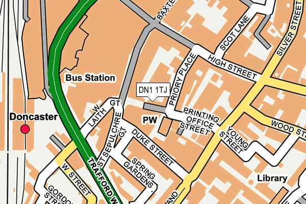
DN1 1TJ is located in the Town electoral ward, within the metropolitan district of Doncaster and the English Parliamentary constituency of Doncaster Central. The Sub Integrated Care Board (ICB) Location is NHS South Yorkshire ICB - 02X and the police force is South Yorkshire. This postcode has been in use since January 1980.


GetTheData
Source: OS OpenMap – Local (Ordnance Survey)
Source: OS VectorMap District (Ordnance Survey)
Licence: Open Government Licence (requires attribution)
| Easting | 457406 |
| Northing | 403201 |
| Latitude | 53.522351 |
| Longitude | -1.135603 |
GetTheData
Source: Open Postcode Geo
Licence: Open Government Licence
| Country | England |
| Postcode District | DN1 |
| ➜ DN1 open data dashboard ➜ See where DN1 is on a map ➜ Where is Doncaster? | |
GetTheData
Source: Land Registry Price Paid Data
Licence: Open Government Licence
Elevation or altitude of DN1 1TJ as distance above sea level:
| Metres | Feet | |
|---|---|---|
| Elevation | 10m | 33ft |
Elevation is measured from the approximate centre of the postcode, to the nearest point on an OS contour line from OS Terrain 50, which has contour spacing of ten vertical metres.
➜ How high above sea level am I? Find the elevation of your current position using your device's GPS.
GetTheData
Source: Open Postcode Elevation
Licence: Open Government Licence
| Ward | Town |
| Constituency | Doncaster Central |
GetTheData
Source: ONS Postcode Database
Licence: Open Government Licence
| January 2024 | Vehicle crime | On or near Parking Area | 409m |
| January 2024 | Violence and sexual offences | On or near Parking Area | 409m |
| December 2023 | Public order | On or near Parking Area | 409m |
| ➜ Get more crime data in our Crime section | |||
GetTheData
Source: data.police.uk
Licence: Open Government Licence
| Ds5 (Duke Street) | Doncaster Town Centre | 74m |
| Mobility Buses Only (St Sepulchre Gate) | Doncaster Town Centre | 77m |
| Ds4 (Duke Street) | Doncaster Town Centre | 81m |
| Duke Street | Doncaster Town Centre | 95m |
| Duke Street | Doncaster Town Centre | 115m |
| Doncaster Station | 0.3km |
| Bentley (S Yorks) Station | 2.6km |
| Kirk Sandall Station | 6.2km |
GetTheData
Source: NaPTAN
Licence: Open Government Licence
GetTheData
Source: ONS Postcode Database
Licence: Open Government Licence


➜ Get more ratings from the Food Standards Agency
GetTheData
Source: Food Standards Agency
Licence: FSA terms & conditions
| Last Collection | |||
|---|---|---|---|
| Location | Mon-Fri | Sat | Distance |
| St Sepulchre Gate | 18:30 | 11:30 | 71m |
| Priory Place | 18:30 | 13:30 | 108m |
| Trafford Court | 18:30 | 11:15 | 193m |
GetTheData
Source: Dracos
Licence: Creative Commons Attribution-ShareAlike
| Facility | Distance |
|---|---|
| The Gym Group (Doncaster) St. Sepulchre Gate, Doncaster Health and Fitness Gym | 80m |
| Oranges (Ladies Only) (Closed) Scot Lane, Doncaster Health and Fitness Gym | 200m |
| Scorpion Taekwondo Centre Scot Lane, Doncaster Sports Hall | 216m |
GetTheData
Source: Active Places
Licence: Open Government Licence
| School | Phase of Education | Distance |
|---|---|---|
| Doncaster UTC College Road, Doncaster, DN1 3BF | Secondary | 439m |
| DN Colleges Group Chappell Drive, Doncaster, DN1 2RF | 16 plus | 645m |
| North Bridge Enterprise College Eco Power Stadium (East Stand), Stadium Way, Doncaster, DN4 5JW | Not applicable | 696m |
GetTheData
Source: Edubase
Licence: Open Government Licence
The below table lists the International Territorial Level (ITL) codes (formerly Nomenclature of Territorial Units for Statistics (NUTS) codes) and Local Administrative Units (LAU) codes for DN1 1TJ:
| ITL 1 Code | Name |
|---|---|
| TLE | Yorkshire and The Humber |
| ITL 2 Code | Name |
| TLE3 | South Yorkshire |
| ITL 3 Code | Name |
| TLE31 | Barnsley, Doncaster and Rotherham |
| LAU 1 Code | Name |
| E08000017 | Doncaster |
GetTheData
Source: ONS Postcode Directory
Licence: Open Government Licence
The below table lists the Census Output Area (OA), Lower Layer Super Output Area (LSOA), and Middle Layer Super Output Area (MSOA) for DN1 1TJ:
| Code | Name | |
|---|---|---|
| OA | E00038726 | |
| LSOA | E01007645 | Doncaster 022E |
| MSOA | E02001560 | Doncaster 022 |
GetTheData
Source: ONS Postcode Directory
Licence: Open Government Licence
| DN1 1BZ | Priory Place | 38m |
| DN1 1BL | Priory Place | 59m |
| DN1 1TS | Priory Walk | 83m |
| DN1 3EA | Duke Street | 120m |
| DN1 1TA | St Sepulchre Gate | 142m |
| DN1 1DE | High Street | 144m |
| DN1 1RU | St Sepulchre Gate | 147m |
| DN1 1ED | High Street | 148m |
| DN1 3DJ | Spring Gardens | 149m |
| DN1 3DY | Cleveland Street | 157m |
GetTheData
Source: Open Postcode Geo; Land Registry Price Paid Data
Licence: Open Government Licence