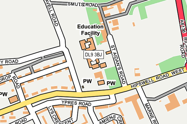
DL9 3BJ is located in the Hipswell & Colburn electoral ward, within the unitary authority of North Yorkshire and the English Parliamentary constituency of Richmond (Yorks). The Sub Integrated Care Board (ICB) Location is NHS Humber and North Yorkshire ICB - 42D and the police force is North Yorkshire. This postcode has been in use since January 1980.


GetTheData
Source: OS OpenMap – Local (Ordnance Survey)
Source: OS VectorMap District (Ordnance Survey)
Licence: Open Government Licence (requires attribution)
| Easting | 417683 |
| Northing | 498248 |
| Latitude | 54.379437 |
| Longitude | -1.729273 |
GetTheData
Source: Open Postcode Geo
Licence: Open Government Licence
| Country | England |
| Postcode District | DL9 |
| ➜ DL9 open data dashboard ➜ See where DL9 is on a map ➜ Where is Catterick Garrison? | |
GetTheData
Source: Land Registry Price Paid Data
Licence: Open Government Licence
Elevation or altitude of DL9 3BJ as distance above sea level:
| Metres | Feet | |
|---|---|---|
| Elevation | 160m | 525ft |
Elevation is measured from the approximate centre of the postcode, to the nearest point on an OS contour line from OS Terrain 50, which has contour spacing of ten vertical metres.
➜ How high above sea level am I? Find the elevation of your current position using your device's GPS.
GetTheData
Source: Open Postcode Elevation
Licence: Open Government Licence
| Ward | Hipswell & Colburn |
| Constituency | Richmond (Yorks) |
GetTheData
Source: ONS Postcode Database
Licence: Open Government Licence
| January 2024 | Vehicle crime | On or near Police Station | 460m |
| November 2023 | Drugs | On or near Police Station | 460m |
| October 2023 | Violence and sexual offences | On or near Police Station | 460m |
| ➜ Get more crime data in our Crime section | |||
GetTheData
Source: data.police.uk
Licence: Open Government Licence
| St Oswalds Crossroads (Hipswell Road West) | Catterick Garrison | 225m |
| St Oswalds Crossroads (Hipswell Road West) | Catterick Garrison | 226m |
| Wardrop Road (Hipswell Road West) | Catterick Garrison | 288m |
| Wardrop Road (Hipswell Road West) | Catterick Garrison | 288m |
| Dane Road (A6136) | Catterick Garrison | 314m |
GetTheData
Source: NaPTAN
Licence: Open Government Licence
GetTheData
Source: ONS Postcode Database
Licence: Open Government Licence


➜ Get more ratings from the Food Standards Agency
GetTheData
Source: Food Standards Agency
Licence: FSA terms & conditions
| Last Collection | |||
|---|---|---|---|
| Location | Mon-Fri | Sat | Distance |
| Hipswell Road West, Catterick G | 16:00 | 11:00 | 1,234m |
| Hilyard Row, Catterick Garrison | 17:00 | 11:00 | 1,451m |
| Holly Hill | 17:15 | 07:30 | 2,098m |
GetTheData
Source: Dracos
Licence: Creative Commons Attribution-ShareAlike
| Facility | Distance |
|---|---|
| Wavell Community Junior School Wavell Road, Catterick Garrison Grass Pitches | 105m |
| Hipswell Road West Playing Fields Hipswell Road East, Catterick Garrison Grass Pitches | 172m |
| Wavell Road Playing Field Wavell Road, Catterick Garrison Grass Pitches, Artificial Grass Pitch | 362m |
GetTheData
Source: Active Places
Licence: Open Government Licence
| School | Phase of Education | Distance |
|---|---|---|
| Catterick Garrison, Wavell Community Infant School Wavell Road, Catterick Garrison, DL9 3BJ | Primary | 77m |
| Wavell Community Junior School Wavell Road, Catterick Garrison, DL9 3BJ | Primary | 77m |
| Carnagill Community Primary School Leadmill Estate, Catterick Garrison, DL9 3HN | Primary | 646m |
GetTheData
Source: Edubase
Licence: Open Government Licence
The below table lists the International Territorial Level (ITL) codes (formerly Nomenclature of Territorial Units for Statistics (NUTS) codes) and Local Administrative Units (LAU) codes for DL9 3BJ:
| ITL 1 Code | Name |
|---|---|
| TLE | Yorkshire and The Humber |
| ITL 2 Code | Name |
| TLE2 | North Yorkshire |
| ITL 3 Code | Name |
| TLE22 | North Yorkshire CC |
| LAU 1 Code | Name |
| E07000166 | Richmondshire |
GetTheData
Source: ONS Postcode Directory
Licence: Open Government Licence
The below table lists the Census Output Area (OA), Lower Layer Super Output Area (LSOA), and Middle Layer Super Output Area (MSOA) for DL9 3BJ:
| Code | Name | |
|---|---|---|
| OA | E00171333 | |
| LSOA | E01033183 | Richmondshire 004G |
| MSOA | E02005785 | Richmondshire 004 |
GetTheData
Source: ONS Postcode Directory
Licence: Open Government Licence
| DL9 3JF | Richmond Road | 421m |
| DL9 3HF | Somerset Close | 434m |
| DL9 3HE | Somerset Close | 474m |
| DL9 3EL | Gough Road | 516m |
| DL9 3HG | Essex Close | 541m |
| DL9 3HQ | Essex Close | 630m |
| DL9 3HN | Derby Close | 647m |
| DL9 4AF | Shute Road | 668m |
| DL9 4AY | Hipswell Road | 762m |
| DL9 3HL | Bedford Close | 783m |
GetTheData
Source: Open Postcode Geo; Land Registry Price Paid Data
Licence: Open Government Licence