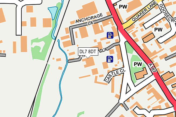
DL7 8DT is located in the Northallerton North & Brompton electoral ward, within the unitary authority of North Yorkshire and the English Parliamentary constituency of Richmond (Yorks). The Sub Integrated Care Board (ICB) Location is NHS Humber and North Yorkshire ICB - 42D and the police force is North Yorkshire. This postcode has been in use since January 1980.


GetTheData
Source: OS OpenMap – Local (Ordnance Survey)
Source: OS VectorMap District (Ordnance Survey)
Licence: Open Government Licence (requires attribution)
| Easting | 436544 |
| Northing | 494254 |
| Latitude | 54.342534 |
| Longitude | -1.439391 |
GetTheData
Source: Open Postcode Geo
Licence: Open Government Licence
| Country | England |
| Postcode District | DL7 |
➜ See where DL7 is on a map ➜ Where is Northallerton? | |
GetTheData
Source: Land Registry Price Paid Data
Licence: Open Government Licence
Elevation or altitude of DL7 8DT as distance above sea level:
| Metres | Feet | |
|---|---|---|
| Elevation | 40m | 131ft |
Elevation is measured from the approximate centre of the postcode, to the nearest point on an OS contour line from OS Terrain 50, which has contour spacing of ten vertical metres.
➜ How high above sea level am I? Find the elevation of your current position using your device's GPS.
GetTheData
Source: Open Postcode Elevation
Licence: Open Government Licence
| Ward | Northallerton North & Brompton |
| Constituency | Richmond (Yorks) |
GetTheData
Source: ONS Postcode Database
Licence: Open Government Licence
| High Street (A167) | Northallerton | 201m |
| High Street (A167) | Northallerton | 227m |
| The Buck Inn (A167) | Northallerton | 252m |
| Friarage Gardens (A684) | Northallerton | 393m |
| Town Hall (High Street) | Northallerton | 414m |
| Northallerton Station | 1.1km |
GetTheData
Source: NaPTAN
Licence: Open Government Licence
GetTheData
Source: ONS Postcode Database
Licence: Open Government Licence


➜ Get more ratings from the Food Standards Agency
GetTheData
Source: Food Standards Agency
Licence: FSA terms & conditions
| Last Collection | |||
|---|---|---|---|
| Location | Mon-Fri | Sat | Distance |
| North End | 17:30 | 11:15 | 157m |
| High Street | 17:30 | 11:15 | 309m |
| Town Hall | 17:30 | 11:15 | 357m |
GetTheData
Source: Dracos
Licence: Creative Commons Attribution-ShareAlike
| Risk of DL7 8DT flooding from rivers and sea | Medium |
| ➜ DL7 8DT flood map | |
GetTheData
Source: Open Flood Risk by Postcode
Licence: Open Government Licence
The below table lists the International Territorial Level (ITL) codes (formerly Nomenclature of Territorial Units for Statistics (NUTS) codes) and Local Administrative Units (LAU) codes for DL7 8DT:
| ITL 1 Code | Name |
|---|---|
| TLE | Yorkshire and The Humber |
| ITL 2 Code | Name |
| TLE2 | North Yorkshire |
| ITL 3 Code | Name |
| TLE22 | North Yorkshire CC |
| LAU 1 Code | Name |
| E07000164 | Hambleton |
GetTheData
Source: ONS Postcode Directory
Licence: Open Government Licence
The below table lists the Census Output Area (OA), Lower Layer Super Output Area (LSOA), and Middle Layer Super Output Area (MSOA) for DL7 8DT:
| Code | Name | |
|---|---|---|
| OA | E00140597 | |
| LSOA | E01027611 | Hambleton 004F |
| MSOA | E02005753 | Hambleton 004 |
GetTheData
Source: ONS Postcode Directory
Licence: Open Government Licence
| DL7 8DS | Tannery Lane | 37m |
| DL7 8DU | Cherry Croft | 99m |
| DL7 8DW | High Street | 115m |
| DL7 8EQ | High Street | 176m |
| DL7 8DJ | High Street | 197m |
| DL7 8EE | High Street | 198m |
| DL6 1EH | Goosecroft Lane | 206m |
| DL6 1FD | Windsor Way | 217m |
| DL7 8EG | High Street | 227m |
| DL6 1EQ | Quaker Lane | 228m |
GetTheData
Source: Open Postcode Geo; Land Registry Price Paid Data
Licence: Open Government Licence