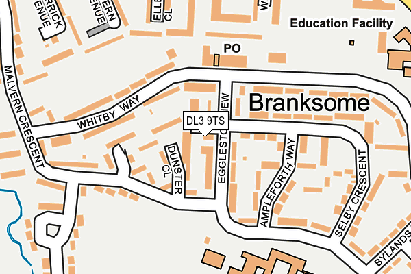
DL3 9TS is located in the Cockerton electoral ward, within the unitary authority of Darlington and the English Parliamentary constituency of Darlington. The Sub Integrated Care Board (ICB) Location is NHS North East and North Cumbria ICB - 16C and the police force is Durham. This postcode has been in use since January 1980.


GetTheData
Source: OS OpenMap – Local (Ordnance Survey)
Source: OS VectorMap District (Ordnance Survey)
Licence: Open Government Licence (requires attribution)
| Easting | 426081 |
| Northing | 516071 |
| Latitude | 54.539249 |
| Longitude | -1.598423 |
GetTheData
Source: Open Postcode Geo
Licence: Open Government Licence
| Country | England |
| Postcode District | DL3 |
| ➜ DL3 open data dashboard ➜ See where DL3 is on a map ➜ Where is Darlington? | |
GetTheData
Source: Land Registry Price Paid Data
Licence: Open Government Licence
Elevation or altitude of DL3 9TS as distance above sea level:
| Metres | Feet | |
|---|---|---|
| Elevation | 60m | 197ft |
Elevation is measured from the approximate centre of the postcode, to the nearest point on an OS contour line from OS Terrain 50, which has contour spacing of ten vertical metres.
➜ How high above sea level am I? Find the elevation of your current position using your device's GPS.
GetTheData
Source: Open Postcode Elevation
Licence: Open Government Licence
| Ward | Cockerton |
| Constituency | Darlington |
GetTheData
Source: ONS Postcode Database
Licence: Open Government Licence
| January 2024 | Criminal damage and arson | On or near Jedburgh Drive | 254m |
| January 2024 | Violence and sexual offences | On or near Jedburgh Drive | 254m |
| January 2024 | Anti-social behaviour | On or near Jedburgh Drive | 254m |
| ➜ Get more crime data in our Crime section | |||
GetTheData
Source: data.police.uk
Licence: Open Government Licence
| Shops (Whitby Way) | Branksome | 98m |
| Ellerton Close (Jedburgh Drive) | Branksome | 253m |
| Woburn Avenue (Malvern Crescent) | Branksome | 272m |
| Wimborne Close (Jedburgh Drive) | Branksome | 301m |
| Branksome Hall Drive (Whitby Way) | Branksome | 317m |
| North Road Station | 2.9km |
| Darlington Station | 3.9km |
GetTheData
Source: NaPTAN
Licence: Open Government Licence
| Percentage of properties with Next Generation Access | 100.0% |
| Percentage of properties with Superfast Broadband | 100.0% |
| Percentage of properties with Ultrafast Broadband | 100.0% |
| Percentage of properties with Full Fibre Broadband | 0.0% |
Superfast Broadband is between 30Mbps and 300Mbps
Ultrafast Broadband is > 300Mbps
| Percentage of properties unable to receive 2Mbps | 0.0% |
| Percentage of properties unable to receive 5Mbps | 0.0% |
| Percentage of properties unable to receive 10Mbps | 0.0% |
| Percentage of properties unable to receive 30Mbps | 0.0% |
GetTheData
Source: Ofcom
Licence: Ofcom Terms of Use (requires attribution)
GetTheData
Source: ONS Postcode Database
Licence: Open Government Licence


➜ Get more ratings from the Food Standards Agency
GetTheData
Source: Food Standards Agency
Licence: FSA terms & conditions
| Last Collection | |||
|---|---|---|---|
| Location | Mon-Fri | Sat | Distance |
| Branksome P.o. | 17:30 | 11:15 | 97m |
| Whitby Way | 17:30 | 10:30 | 515m |
| Edgecombe Drive | 17:30 | 10:15 | 752m |
GetTheData
Source: Dracos
Licence: Creative Commons Attribution-ShareAlike
| Facility | Distance |
|---|---|
| Wyvern Academy Eggleston View, Darlington Swimming Pool, Sports Hall, Grass Pitches, Studio | 203m |
| Mount Pleasant Primary School (Darlington) Newton Lane, Darlington Grass Pitches | 305m |
| Staindrop Road Playing Field Staindrop Road, Darlington Grass Pitches | 445m |
GetTheData
Source: Active Places
Licence: Open Government Licence
| School | Phase of Education | Distance |
|---|---|---|
| Wyvern Academy Eggleston View, Darlington, DL3 9SH | Secondary | 204m |
| Mount Pleasant Primary School Newton Lane, Darlington, DL3 9HE | Primary | 305m |
| Marchbank Free School Mowden Hall, Barnes Road, Darlington, DL3 9BL | Not applicable | 925m |
GetTheData
Source: Edubase
Licence: Open Government Licence
The below table lists the International Territorial Level (ITL) codes (formerly Nomenclature of Territorial Units for Statistics (NUTS) codes) and Local Administrative Units (LAU) codes for DL3 9TS:
| ITL 1 Code | Name |
|---|---|
| TLC | North East (England) |
| ITL 2 Code | Name |
| TLC1 | Tees Valley and Durham |
| ITL 3 Code | Name |
| TLC13 | Darlington |
| LAU 1 Code | Name |
| E06000005 | Darlington |
GetTheData
Source: ONS Postcode Directory
Licence: Open Government Licence
The below table lists the Census Output Area (OA), Lower Layer Super Output Area (LSOA), and Middle Layer Super Output Area (MSOA) for DL3 9TS:
| Code | Name | |
|---|---|---|
| OA | E00062089 | |
| LSOA | E01012314 | Darlington 006F |
| MSOA | E02002564 | Darlington 006 |
GetTheData
Source: ONS Postcode Directory
Licence: Open Government Licence
| DL3 9TR | Dunster Close | 41m |
| DL3 9SL | Eggleston View | 71m |
| DL3 9TU | Atherstone Way | 72m |
| DL3 9SJ | Eggleston View | 74m |
| DL3 9TP | Malvern Crescent | 101m |
| DL3 9UG | Whitby Way | 111m |
| DL3 9SG | Ampleforth Way | 113m |
| DL3 9TX | Sawley Close | 133m |
| DL3 9UQ | Whitby Way | 152m |
| DL3 9UZ | Kelso Walk | 154m |
GetTheData
Source: Open Postcode Geo; Land Registry Price Paid Data
Licence: Open Government Licence