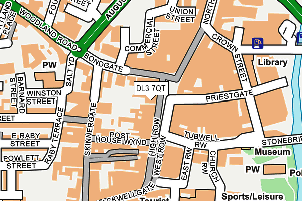
DL3 7QT is located in the Park East electoral ward, within the unitary authority of Darlington and the English Parliamentary constituency of Darlington. The Sub Integrated Care Board (ICB) Location is NHS North East and North Cumbria ICB - 16C and the police force is Durham. This postcode has been in use since January 1980.


GetTheData
Source: OS OpenMap – Local (Ordnance Survey)
Source: OS VectorMap District (Ordnance Survey)
Licence: Open Government Licence (requires attribution)
| Easting | 428861 |
| Northing | 514578 |
| Latitude | 54.525671 |
| Longitude | -1.555594 |
GetTheData
Source: Open Postcode Geo
Licence: Open Government Licence
| Country | England |
| Postcode District | DL3 |
| ➜ DL3 open data dashboard ➜ See where DL3 is on a map ➜ Where is Darlington? | |
GetTheData
Source: Land Registry Price Paid Data
Licence: Open Government Licence
Elevation or altitude of DL3 7QT as distance above sea level:
| Metres | Feet | |
|---|---|---|
| Elevation | 50m | 164ft |
Elevation is measured from the approximate centre of the postcode, to the nearest point on an OS contour line from OS Terrain 50, which has contour spacing of ten vertical metres.
➜ How high above sea level am I? Find the elevation of your current position using your device's GPS.
GetTheData
Source: Open Postcode Elevation
Licence: Open Government Licence
| Ward | Park East |
| Constituency | Darlington |
GetTheData
Source: ONS Postcode Database
Licence: Open Government Licence
| June 2022 | Bicycle theft | On or near Prebend Row | 44m |
| June 2022 | Drugs | On or near Prebend Row | 44m |
| June 2022 | Drugs | On or near Prebend Row | 44m |
| ➜ Get more crime data in our Crime section | |||
GetTheData
Source: data.police.uk
Licence: Open Government Licence
| Prebend Row | Darlington | 47m |
| Prebend Row | Darlington | 60m |
| Tubwell Row | Darlington | 97m |
| Tubwell Row | Darlington | 114m |
| Tubwell Row | Darlington | 128m |
| Darlington Station | 0.8km |
| North Road Station | 1.2km |
GetTheData
Source: NaPTAN
Licence: Open Government Licence
GetTheData
Source: ONS Postcode Database
Licence: Open Government Licence


➜ Get more ratings from the Food Standards Agency
GetTheData
Source: Food Standards Agency
Licence: FSA terms & conditions
| Last Collection | |||
|---|---|---|---|
| Location | Mon-Fri | Sat | Distance |
| High Row A | 18:30 | 11:45 | 118m |
| High Row | 18:30 | 11:45 | 118m |
| Bondgate | 18:00 | 11:30 | 129m |
GetTheData
Source: Dracos
Licence: Creative Commons Attribution-ShareAlike
| Facility | Distance |
|---|---|
| The Fitness Centre (Closed) Bondgate, Darlington Health and Fitness Gym, Studio | 97m |
| Penthouse Fitness Suite Skinnergate, Darlington Health and Fitness Gym | 227m |
| The Dolphin Centre Horse Market, Darlington Sports Hall, Swimming Pool, Health and Fitness Gym, Squash Courts, Studio | 238m |
GetTheData
Source: Active Places
Licence: Open Government Licence
| School | Phase of Education | Distance |
|---|---|---|
| Borough Road Nursery School Borough Road, Darlington, DL1 1SG | Nursery | 504m |
| George Dent Nursery School Elms Road, Elms Road, Darlington, DL3 7PY | Nursery | 592m |
| Queen Elizabeth Sixth Form College Vane Terrace, Darlington, DL3 7AU | 16 plus | 625m |
GetTheData
Source: Edubase
Licence: Open Government Licence
The below table lists the International Territorial Level (ITL) codes (formerly Nomenclature of Territorial Units for Statistics (NUTS) codes) and Local Administrative Units (LAU) codes for DL3 7QT:
| ITL 1 Code | Name |
|---|---|
| TLC | North East (England) |
| ITL 2 Code | Name |
| TLC1 | Tees Valley and Durham |
| ITL 3 Code | Name |
| TLC13 | Darlington |
| LAU 1 Code | Name |
| E06000005 | Darlington |
GetTheData
Source: ONS Postcode Directory
Licence: Open Government Licence
The below table lists the Census Output Area (OA), Lower Layer Super Output Area (LSOA), and Middle Layer Super Output Area (MSOA) for DL3 7QT:
| Code | Name | |
|---|---|---|
| OA | E00062058 | |
| LSOA | E01033484 | Darlington 008F |
| MSOA | E02002566 | Darlington 008 |
GetTheData
Source: ONS Postcode Directory
Licence: Open Government Licence
| DL3 7JA | Bondgate | 47m |
| DL1 1NT | Prebend Row | 53m |
| DL3 7JE | Bondgate | 73m |
| DL1 1NW | Priestgate | 94m |
| DL3 7LP | Post House Wynd | 98m |
| DL1 1NX | Tubwell Row | 100m |
| DL3 7QL | Bucktons Yard | 107m |
| DL3 7LU | Post House Wynd | 108m |
| DL1 1NR | Northgate | 110m |
| DL3 7QQ | High Row | 115m |
GetTheData
Source: Open Postcode Geo; Land Registry Price Paid Data
Licence: Open Government Licence